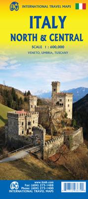
Wegenkaart - landkaart Italy North & Central | ITMB

0
Italy is a very densely populated country, requiring sectional maps to portray its complex road/rail network in sufficient detail to make sense. This is a brand new title for ITMB, covering the central portion of the peninsula from Naples north to Florence on side one, and includes a large inset map of Sardinia. Side two covers the vast expanse of...

Verkopers met dit product

Verkoper
Bezorging
Prijs
DeZwerver.nl logo
DeZwerver.nl
2,95
13,95

Anderen bekeken ook

Wegenkaart - landkaart Italy North & Central | ITMB
Italy is a very densely populated country, requiring sectional maps to portray its complex road/rail network in sufficient detail to make sense. This is a brand new title for ITMB, covering the central portion of the peninsula from Naples north to Florence on side one, and includes a large inset map of Sardinia. Side two covers the vast expanse of the north of the country, from the high alpine valleys of D’Aosta and Trentino to the plains of northern Italy and the coastal provinces of the Mediterranean and Adriatic coastlines. The immediate border areas of France and Switzerland are included, but the extensive plate name index covers most of those countries. Motorways (in blue) tend to be toll highways. Multi-lane highways (in magenta) and principal highways (in green) tend to be non-toll. The red lines are ordinary two-lane roadways, and tend to go through villages every kilometer or so and to follow mountainous contours. We spent a week in January, 2020, in the Rome to Naples to Mon…
13,95
Wegenkaart - landkaart Japan Central | ITMB
Een degelijke kaart met aanduidingen van o.a. nationale parken, vliegveld, benzinepomp, dirt-roads. Als overzichtskaart goed te gebruiken.   This is a brand new title for ITMB, a double-sided map covering the ‘core’ regions of Japan most visited by tourists exploring Japan. Side 1 covers from Tokyo north to Sendai/Nigata and west to Nagoya. Side two covers all of Japan as far as Hiroshima, with insets of the Osaka/Kobe and Kyoto/Nara regions. Naturally, all touristic attractions are noted.   Legend Includes: Roads by classification, Rivers and Lakes, National Park, Airports, Points of Interests, Highways, Main Roads, Zoos, Fishing, and much more...
13,95
Stadsplattegrond - Wegenkaart - landkaart Quito & Ecuador Central | ITMB
Een degelijke wegenkaart van Ecuador met aanduidingen van o.a. nationale parken, vliegveld, benzinepomp, dirt-roads en kleine plattegrond van hoofdstad. Als overzichtskaart goed te gebruiken. Finally, ITMB releases its long-awaited re-worked map of the wonderful South America city of Quito. The city is squeezed in between mountain ranges and, the entire city stretches from north (on the right-hand side of the map) to the south. The "bottom" of the map is, actually the eastern portion. A regional inset map clarifies the situation. The street network is clearly shown, along with the rapid line bus way and the city's Metro. The Old Town is perhaps the most interesting portion of the city for visitors and is on the left-hand portion of the map. The newer downtown is centered on La Carolina Park on the right-hand side of the map. This is where most of the shopping malls and hotels are located. The old airport is shown in part on the far right, but the new international airport is located f…
13,95
Wegenkaart - landkaart Midden Amerika - Central America | ITMB
Een degelijke kaart met aanduidingen van o.a. nationale parken, vliegveld, benzinepomp, dirt-roads. Als overzichtskaart goed te gebruiken. Met Belize, Guatemala, Honduras, El Salvador, Nicaragua, Costa Rica en Panama. Folded color road and travel map. Scale 1:1,100,000. Distinguishes roads ranging from highways (paved/unpaved) to seasonal tracks. Legend includes swamps, glaciers, reefs, active volcanoes, railways, ferry routes, protected areas/national parks, international airports, domestic airports with scheduled services, landing grounds, points of interest, ruins, lighthouses, mines, beaches, gas stations, border crossing points. Includes inset map of Panama Canal Area, Isla del Coco. Extensive index, general information on the listed countries.  
13,95
Wegenkaart - landkaart Western Australia | ITMB
The State of Western Australia occupies the western third of the continental country of Australia. The main city is Perth, in the southwest portion, and this is the part of the State with the best land and the most people. Much of the interior is arid desert-like grassland with shallow lakes that often dry out. The road network in the south is generally paved highways and secondary roads, with one road and one rail line heading east to SZ and the rest of the country. Roads in the north tend to be dirt, with the exception of the highway going towards Darwin in NT. There are no roads through the Great Sandy Desert, but the Canning Stock Route crosses the eastern fringe, going north-south. One needs an expensive permit to drive this hazardous track. Most of the attractions of the State are to be found fairly close to the coastline. Most of the larger urban areas tend to have been named after British places, such as Albany, Exmouth, and Port Hedland, but many names have been adopted from …
13,95
Wegenkaart - landkaart Australia South & Northern Territory | ITMB
Australia was one of the first countries ITMB published, back in the 1980s, albeit a licensed version. Our own original artwork was completed in the mid-1990s, but until recently, we have not focused on sectional maps of the country based on individual states. In 2019, we published Brisbane and Queensland, and Sydney and New South Wales. Now, we are issuing the ‘middle’ states of South Australia and Northern Territory to provide better coverage of these important parts of Australia at a better scale than a country map could provide. South Australia can be thought of as having two parts; the fertile farming economy surrounding Adelaide in the south and the much more arid northern portion. The road network in the south tends to be well developed, with paved roads going more or less east-west to NSW and WA. Northerly roads tend to be gravel or dirt, such as the Birdville Track, and the north-westerly roads tend to pass through land ceded to aboriginals and require permits. Northern Terri…
13,95
Wegenkaart - landkaart Africa central and south - Afrika zuid en centraal | ITMB
This title is in our series of regional titles for Africa at 1:3,400,000 scale. All of Africa is available as a continental sheet at 1:5M scale and as regional titles at 1:3.8M and 1:3.4M, based on GIS data. This is a milestone for ITMB and the realization of a dream that began in 1993. However, the work is still only in its early stages. This map covers that portion of the continent that old Africa hands always referred to as 'central', meaning the Rhodesias and Nyasaland now known as Zambia, Malawi, and Zimbabwe.   By its shape, generous portions of the southern portions of DEM Congo, the eastern third of Angola, the northern half of Mozambique, and Botswana's Okavunga Delta are included on the one side. The second side covers South Africa, Lesotho, Swaziland, the rest of Botswana, and southern Namibia in great detail. This is an excellent map for anyone visiting the larger region of the southern third of Africa. As with our other regional titles, this is a work in progress. The nex…
13,95
Wegenkaart - landkaart Japan North & Hokkaido | ITMB
Een degelijke kaart met aanduidingen van o.a. nationale parken, vliegveld, benzinepomp, dirt-roads en kleine plattegrond van hoofdstad. Als overzichtskaart goed te gebruiken. In one sense, this is a brand new map, in that the artwork is all brand new. In another sense, it is our map of Hokkaid re-worked into a more marketable format. In any case, it is a very much-needed sectional map of that portion of Japan from Tokyo northwards. Hokkaido is actually one of the most interesting parts of Japan to visit. The island was opened to settlement only after the Ameicans forced Japan to allow contacts with foreign countries in 1868, thanks to Admiral Peary and Gunboat Diplomacy. Hokkaido has been relatively untouched by Japan’s rush to economic dominance, so is the country’s skiing capital in winter and the part of Japan most similar to America. An inset map of Sapporo is included. The other side shows the main island of the country from Nagoya and Toyama (which are considerably west of Tokyo…
13,95
Wegenkaart - landkaart - Wegenatlas Pan-Americana North | ITMB
Wegenatlas - A5 formaat - verschillende schalen - voor de het Noord-Amerikaanse gedeelte van de Pan-Americana ( Pan-American Highway ) van Alaska langs the Pacific kust van British Colombia in Canada, de staten Washington, Oregon en Californie, Mexico, Guatemala tot Panama.   The Pan-American Highway was created by the USA to improve road communications within the Western Hemisphere post-WW2. The highway started at the Mexican border and eventually reached somewhere south of Santiago in Chile. It was a vote-buying gimmick by the Americans to fund allies, but it also created an essential 'spine' road through Central America to the Darien Gap and along the west coast of South America to the then-limits of Chile. Driving the Pan-Am has become a travel experience. More recently, the improvement in more northerly highways, such as the Dalton Highway from Fairbanks to Prudhoe Bay in Alaska, the paving of most of the Stewart Highway through British Columbia, and the tremendous improvement in…
16,50
Wegenkaart - landkaart USA Verenigde Staten | ITMB
Een degelijke kaart met aanduidingen van o.a. nationale parken, vliegveld, benzinepomp, dirt-roads en kleine plattegrond van hoofdstad. Als overzichtskaart goed te gebruiken. United States of America (USA) Travel Reference Map has been mapped before, but the USA is a huge country, extremely developed, and almost impossible to show on a map without over-simplification. Most commercial maps use small sheets of paper and print single-sided, making it impossible to show this vast country to advantage. Well, Lan’s been hard at work developing a ‘proper’ traveller’s aid to navigating around the USA, and here it is. We printed it on an exceptionally large sheet of paper, 39” tall by 54” wide (our normal printing size is 27”x39”). To do this, we merged our four existing databases into one, then split them so that the west side is on one side and the east side on the other. What results is a very large sheet, but a map at a VERY good scale. We were able to fit in 6,765 urban areas, all the Int…
13,95

Klanten-reviews van Wegenkaart - landkaart Italy North & Central | ITMB

Er zijn nog geen beoordelingen voor dit productBen jij de eerste die een review plaatst?

Meer over Wegenkaart - landkaart Italy North & Central | ITMB

Productomschrijving

Italy is a very densely populated country, requiring sectional maps to portray its complex road/rail network in sufficient detail to make sense. This is a brand new title for ITMB, covering the central portion of the peninsula from Naples north to Florence on side one, and includes a large inset map of Sardinia. Side two covers the vast expanse of the north of the country, from the high alpine valleys of D’Aosta and Trentino to the plains of northern Italy and the coastal provinces of the Mediterranean and Adriatic coastlines. The immediate border areas of France and Switzerland are included, but the extensive plate name index covers most of those countries. Motorways (in blue) tend to be toll highways. Multi-lane highways (in magenta) and principal highways (in green) tend to be non-toll. The red lines are ordinary two-lane roadways, and tend to go through villages every kilometer or so and to follow mountainous contours. We spent a week in January, 2020, in the Rome to Naples to Montecassino triangle, and found the roads to be in good condition. We are now working on a companion map covering southern Italy, and on a detailed map of Sardinia to join our exiting maps of Sicily, Rome, and Venice.   Legend Includes: Roads by classification, Rivers and Lakes, National Park, Airports, Points of Interests, Mining, Highways, Main Roads, Zoos, Fishing, , and much more...

Productinformatie

    Verken gerelateerde categorieën

    Webshop.nl maakt gebruik van cookies. Ga je verder op onze website, ga dan akkoord met het plaatsen van cookies en de verwerking van deze data door ons en vermelde partners.