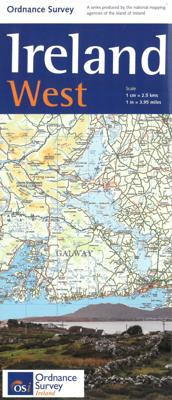
Wegenkaart - landkaart Ireland West ( Ierland ) | Ordnance Survey Ireland

0
Hele duidelijke kaarten van een groot gebied: Ierland is in vieren gedeeld. Met alle noodzakelijke informatie, bijna topografisch van aard. Campings en bezienswaardigheden zijn er o.a. op terug te vinden! Veel wegen staan ingetekend, spoorlijnen, vliegvelden maar ook nationale parken zijn er goed op ingetekend.   Whether you are on a motoring tour...

Verkopers met dit product

Verkoper
Bezorging
Prijs
DeZwerver.nl logo
DeZwerver.nl
2,95
19,50

Anderen bekeken ook

Wegenkaart - landkaart Ireland West ( Ierland ) | Ordnance Survey Ireland
Hele duidelijke kaarten van een groot gebied: Ierland is in vieren gedeeld. Met alle noodzakelijke informatie, bijna topografisch van aard. Campings en bezienswaardigheden zijn er o.a. op terug te vinden! Veel wegen staan ingetekend, spoorlijnen, vliegvelden maar ook nationale parken zijn er goed op ingetekend.   Whether you are on a motoring tour or exploring cross-country, these maps show you how to get there. They contain a clear presentation of the road network. Tourist features such as tourist offices, official caravan parks and picnic areas are also shown. These are clearly marked and easy to follow. Planning your itinerary is therefore made as simple as possible.
19,50
Wegenkaart - landkaart Ireland North ( Ierland ) | Ordnance Survey Ireland
Hele duidelijke kaarten van een groot gebied: Ierland is in vieren gedeeld. Met alle noodzakelijke informatie, bijna topografisch van aard. Campings en bezienswaardigheden zijn er o.a. op terug te vinden! Veel wegen staan ingetekend, spoorlijnen, vliegvelden maar ook nationale parken zijn er goed op ingetekend. Whether you are on a motoring tour or exploring cross-country, these maps show you how to get there. They contain a clear presentation of the road network. Tourist features such as tourist offices, official caravan parks and picnic areas are also shown. These are clearly marked and easy to follow. Planning your itinerary is therefore made as simple as possible.
19,50
Wegenkaart - landkaart Ireland East ( Ierland ) | Ordnance Survey Ireland
Hele duidelijke kaarten van een groot gebied: Ierland is in vieren gedeeld. Met alle noodzakelijke informatie, bijna topografisch van aard. Campings en bezienswaardigheden zijn er o.a. op terug te vinden! Veel wegen staan ingetekend, spoorlijnen, vliegvelden maar ook nationale parken zijn er goed op ingetekend.   Whether you are on a motoring tour or exploring cross-country, these maps show you how to get there. They contain a clear presentation of the road network. Tourist features such as tourist offices, official caravan parks and picnic areas are also shown. These are clearly marked and easy to follow. Planning your itinerary is therefore made as simple as possible.
19,50
Wegenkaart - landkaart Ireland South ( Ierland ) | Ordnance Survey Ireland
Hele duidelijke kaarten van een groot gebied: Ierland is in vieren gedeeld. Met alle noodzakelijke informatie, bijna topografisch van aard. Campings en bezienswaardigheden zijn er o.a. op terug te vinden! Veel wegen staan ingetekend, spoorlijnen, vliegvelden maar ook nationale parken zijn er goed op ingetekend.   Whether you are on a motoring tour or exploring cross-country, these maps show you how to get there. They contain a clear presentation of the road network. Tourist features such as tourist offices, official caravan parks and picnic areas are also shown. These are clearly marked and easy to follow. Planning your itinerary is therefore made as simple as possible.
19,50
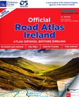
Wegenatlas Official Roadatlas of Ireland - Ierland | Ordnance Survey Ireland
Mooie atlas met bijzonder kleurgebruik. Hoogte wordt hierdoor zeer duidelijk weergegeven. Met alle noodzakelijke en toeristische informatie, afstandentabel, stadsplattegronden en register . In ringband uitgevoerd tussen A4 en A5 qua formaat. This road atlas contains detailed road maps of the whole of Ireland. In addition it also contains City and Town Maps, Touring and Motoring information, a distance chart, full gazetteer and the location of every Golf Union of Ireland golf course.
24,95
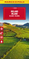
Wegenkaart - landkaart Ierland - Ireland | Marco Polo
Duidelijke wegenkaart van Marco Polo: alle wegen, zowel de verharde als belangrijke onverharde wegen zijn weergegeven.  Mooie toeristisch interessante wegen die de moeite waard zijn, zijn groen gearceerd. Veel toeristische informatie is toegevoegd zoals de nationale parken, campings, kastelen en vliegvelden. Afstanden tussen belangrijke steden en benzinestations staan ook op de kaart.  Discover picturesque towns and dramatic coastlines with this highly durable, detailed touring map of Ireland. It folds away easily and is always on standby to help when you're stuck.   Perfect touring map - the scale is 1 : 350 000 ideal to help you tour the country by car or campervan Easy to use - the superbly clear mapping in strong colours and easy to read text will help you navigate the country like a local Durable, tear-resistant map - designed to withstand the rigors of the road, the map is printed on tear-resistant, water repellent and writeable paper Highlights included - major sights and key p…
14,95
Wegenkaart - landkaart Ireland - Ierland | Borch
Mooie geplasticieerde kaart van Ierland. Deze kaart biedt een goed overzicht van het land met detailkaarten.   Our soft-laminated folded map of Ireland shows: Ireland 1:700 000, Dublin 1:15 000, Cork 1:8 000, Killarney National Park 1:100 000, Wicklow Mountains 1:350 000 and Ireland administrative. Borch maps are easy to fold, durable and water-repellent with a wipeable surface. Borch Maps show hotels, museums, monuments, markets, top sights and points of interest, useful statistics, conversion charts for temperatures, weights and measurements, climate charts showing temperatures, sunshine hours, precipitation and humidity, overview maps, time zones, and much more...   Once one has torn oneself away from the bustling, cosmopolitan atmosphere of Dublin, the "Emerald Isle" more than confirms its reputation: lush green meadows and peat mores dotted with stone walls and the occasional small house; rugged cliffs and windswept hillsides populated only by sheep; long sandy beaches all to you…
11,50
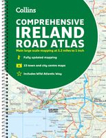
Wegenatlas Ireland Comprehensive Road Atlas - Ierland | Collins
Duidelijke en gedetailleerde atlas voor Ierland in A4-formaat met ringband.   Clear, detailed road atlas of Ireland in a handy A4 spiral-bound format. This comprehensive, general purpose road atlas of the whole of Ireland is ideal for both business and pleasure use. The atlas contains a range of mapping scales: • 9 miles to 1 inch route planning map • Main maps at 3.2 miles to 1 inch, which are ideal for navigation. • A wide selection of detailed town centre street plans.   This edition boasts road mapping packed with detail showing colour classified road network, toll roads, land heights, the location of safety cameras, Blue Flag and Green Coast beaches, tourist information centres and a wide range of tourist attractions. There is also comprehensive guide information for visitors to Belfast, Cork, Dublin and Limerick. The locations of Speed Enforcement Zones, which highlight roads that have a high risk of accidents as identified by the Garda and the National Roads Authority, are incl…
14,95
Wegenkaart - landkaart Ireland - Ierland | AA Publishing
Folded, double-sided sheet map shows the detailed road network with toll motorways and dual carriageways identified. Includes motorway service areas, AA-inspected campsites, viewpoints and picnic sites. Gaeltacht regions are highlighted with place names in English and Irish. Includes 6 city plans of Dublin, Belfast, Cork, Derry Londonderry, Sligo and Waterford and 5 port plans. A separate map of Ireland features relief shading with key physical landmarks. City, town and port plans. Distance in miles and kilometers.
8,95

Klanten-reviews van Wegenkaart - landkaart Ireland West ( Ierland ) | Ordnance Survey Ireland

Er zijn nog geen beoordelingen voor dit productBen jij de eerste die een review plaatst?

Meer over Wegenkaart - landkaart Ireland West ( Ierland ) | Ordnance Survey Ireland

Productomschrijving

Hele duidelijke kaarten van een groot gebied: Ierland is in vieren gedeeld. Met alle noodzakelijke informatie, bijna topografisch van aard. Campings en bezienswaardigheden zijn er o.a. op terug te vinden! Veel wegen staan ingetekend, spoorlijnen, vliegvelden maar ook nationale parken zijn er goed op ingetekend.   Whether you are on a motoring tour or exploring cross-country, these maps show you how to get there. They contain a clear presentation of the road network. Tourist features such as tourist offices, official caravan parks and picnic areas are also shown. These are clearly marked and easy to follow. Planning your itinerary is therefore made as simple as possible.

Productinformatie

    Verken gerelateerde categorieën

    Webshop.nl maakt gebruik van cookies. Ga je verder op onze website, ga dan akkoord met het plaatsen van cookies en de verwerking van deze data door ons en vermelde partners.