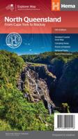
Wegenkaart - landkaart Explorer Map North Queensland | Hema Maps

0
Detailkaart van een deel van Australië. Zeer goed leesbaar, met naast de topografische details veel symbolen waarmee allerhande toeristische zaken worden aangeduid als campsites, nationale parken, attracties, wandelmogelijkheden etc. Covering Australia's beautiful North Queensland. There is alot of town map insets, tourist information, and photogr...

Verkopers met dit product

Webshop
Bezorging
Prijs
DeZwerver.nl logo
DeZwerver.nl
2,95
17,50

Anderen bekeken ook

Wegenkaart - landkaart Costa Blanca Valencia | Marco Polo
Goede wegenkaart van een deel van Spanje,met schaal 1:200.000: meer details dan de Michelin wegenkaarten van Spanje. Deze kaarten hebben een register, een tabel met afstanden tussen steden, enkele centrumkaarten van de meest belangrijke steden, vermelding van o.a. campings aan de hand van symbolen alsmede de bezienswaardigheden. Ook benzinepompen worden bijvoorbeeld vermeld! The map boldly stresses main roads and motorways in strong colours and selected towns in large letters, but also shows minor roads and villages in considerable detail. Road information includes toll roads, traffic restrictions and seasonal closures, gradient marking for steep roads, scenic roads and special tourist routes, etc. Motorway services clearly indicate types of facilities available there. Railway network is shown with stations and includes tourist lines Picturesque towns or villages and sites worth visiting, including areas with interesting landscape, are given star rating, and other tourist information …
14,95
Wegenkaart - landkaart Explorer Map Central Queensland | Hema Maps
Detailkaart van een deel van Australië. Zeer goed leesbaar, met naast de topografische details veel symbolen waarmee allerhande toeristische zaken worden aangeduid als campsites, nationale parken, attracties, wandelmogelijkheden etc. A regional map of central Queensland (1:1,000,000) that stretches inland past Jericho and from Maryborough in the south to Mackay in the north. On the opposite side is tourist information on the region, as well as inset maps of Mackay, the Capricorn Coast, Gladstone, Bundaberg, Rockhampton, and the Gemfields. Accompanying each inset map are photos as well as background and travel information on the region that help for planning and touring.  
17,50
Wegenkaart - landkaart The Cotswolds | Philip's Maps
A new edition of this double-sided map of the Cotswolds clearly featuring places of tourist and historic interest in an easy-to-read style of mapping, alongside six handy town centre plans. This leisure and tourist map of the Cotswolds gives detailed coverage of the area's road network at a scale of approximately 2 miles to 1 inch (1:125,000). The coverage stretches from Abingdon in the east to Gloucester in the west, and from Swindon in the south to Great Malvern in the north. The map shows places of tourist and historic interest, including castles, camping and caravanning sites, country parks, galleries, gardens, golf courses, museums, nature trails, historic sites, sports venues, theatres and wildlife parks. An index to principal places of interest is also featured. With some of the most enchanting towns and cities in England in the area - all with extraordinary history and notable natural beauty - use the Philip's Leisure Map to explore and delight in the Cotswold magic. Includ…
11,50
Wegenkaart - landkaart Okavango Delta - Tourist Map of the Okavango Delta and Linyanti Botswana - Veronica Roodt | Shell
Zeer bijzondere landkaart van de Okavango Delta en Linyanti. Uitermate handig zijn de GPS coördinaten van de meest belangrijke punten als campings of uitzichtpunten. De kaart is gebaseerd op een luchtfoto, waarbij alle details zijn ingetekend. The map: The map of the Okavango and Linyanti was compiled by using LANDSAT satellite images. The main reason for a tourist map of the area is to indicate the localities of the lodges as well as the wildlife management areas in which they occur. Tourists to the Okavango often visit more than one lodge and this will give them a good idea of where they have been. On the back of the map are enlargements of the different tourist areas, which shows more detail of the landscape. There are no GPS co-ordinates on the Okavango map as all the Wildlife areas consist of private concessions, which are not open to the general public. The roads in the private concessions have also not been indicated as this may mislead the self-driving public, making them thin…
17,50
Wandelkaart Suva Planina - Servië | Geokarta
One side topographic marked with footpaths, ski trails, ski lifts, camp sites, picnic sites, mountain huts, also notable features in the landscape. Other side further information, additional words and pics of notable features, mountain huts etc. Suva Mountains with the Gorges of the Jelašnicka River on a detailed contoured map at 1:55,000, plus extensive information on the tourist facilities in the area with colour photos of mountain shelters, notes on fauna and flora, etc. The map has contours at 20m intervals with relief shading and colouring for woodlands. Different levels of protection zones are marked and areas where hunting is allowed are indicated. An overprint highlights waymarked hiking trails including the 130km long-distance trail across the Niš range. Also marked are different types of tourist accommodation including campsites and hunting lodges, paragliding sites, skiing areas, etc. The map has latitude and longitude lines at intervals of 5’. Map legend includes English. …
13,95
Wegenkaart - landkaart Great Desert Tracks Simpson Desert - Simpson woestijn | Hema Maps
Detailkaart van een deel van Australië. Zeer goed leesbaar, met naast de topografische details veel symbolen waarmee allerhande toeristische zaken worden aangeduid als campsites, nationale parken, attracties, wandelmogelijkheden etc. Hema's Great Desert Tracks maps are essential for anyone travelling in the Australian outback. The mapping features roads and 4WD tracks field-checked by the Hema Map Patrol, Points of Interest for remote area travellers and touring information for learning more about the region and planning your journey.   Discover the Simpson Desert with detailed mapping, relevant points of interest and essential touring information for the journey. One side of the map covers the desert at a scale of 1:500,000, while the other is at 1:1,000,000 for planning purposes. Marked on the mapping are roads and 4WD tracks checked by the Hema Map Patrol, distance markers, topographical relief and touring points of interest including 24-hour fuel, camping areas and caravan park…
17,50
Wegenkaart - landkaart Kgalagadi - Tourist Map of Kgalagadi Transfrontier Park Botswana | Shell
Zeer bijzondere landkaart van het grensgebied van Botswana en Zuid Afrika. Uitermate handig zijn de GPS coordinaten van de meest belangrijke punten als campings of uitzichtpunten. De kaart is gebaseerd op een luchtfoto, waarbij alle details zijn ingetekend. The map: The map consists of a large map of the entire Park on the front of the map. On the back is enlargements of six maps - the South African side, Mabuasehube, Swart Pan area, Gemsbok Wilderness Trail, Mabuasehube Wilderness Trail and of the Kaa Kalahari Concession. Satellite images were used and the roads were tracked by GPS. There are 168 GPS coordinates on this map. Establishment of a Transfrontier Park: On the 7 th of April 1999 Botswana and South Africa signed a bilateral agreement in which they agreed to manage their adjacent national parks, Gemsbok National Park in Botswana and Kalahari Gemsbok National Park in South Africa, as a single ecological unit – the Kgalagadi Transfrontier Park. It is the first formally declared…
17,50
Wandelkaart The Broads | Heron Maps
A full colour map of the Broads suitable for both waterways and leisure users.   This map gives detailed coverage of the Broads with emphasis on the waterways and information useful and relevant to users of the waterways without neglecting other leisure users. The map detail is complimented by information panels and photographs.   Our cruising and tourist map of the Broads is at 1:50000 with detailed town plans at 1:12500 for Wroxham and Hoveton, Stalham, Horning, Potter Heigham, Norwich, Brundall, Beccles, Loddon, Great Yarmouth, Reedham and Oulton Broad.   A double side map with the map on one side and boating and vistor information of the other. The map shows navigation information, visitor moorings, boatyards, boat hire centres, facilities for the boat user and shops. Tourist information includes places of interest, pubs, nature reserves, windmills, churches, long distance paths, public toilets and caravan and camp sites. The reverse side has detailed boating information including…
9,95
Ik ben 18+
Wegenkaart - landkaart Whisky map of Scotland | Collins
Wegenkaart met meer dan 100 distilleerderijen en whisky gerelateerde locaties.   Discover where Scotland’s national drink is produced. All of Scotland’s operational whisky distilleries and whisky-related places of interest located on one map. Also includes an easy-to-use index listing visitor facilities, contact details and websites. The map includes:   • Over 100 distilleries and whisky-related places of interest • Insert map of malt whisky areas • A photographic guide to how whisky is made • Selection of labels of blended Scotch whisky brands • Did you know? Section with interesting facts • World maps of main export markets • Index lists visitor facilities, telephone numbers and websites   Scotch whisky is unique among national drinks – synonymous with Scotland, it cannot be produced elsewhere in the world.   Other titles in the series: Castles Map of Scotland, Tartans Map of Scotland, Scotland of Old Clans Map  
9,95
Wandelkaart NS504 Upper and Lower Dolpa - Dolpo | Himalayan Maphouse
Goede duidelijk leesbare  map voor trekkings in Dolpo. Van Juphal en Jejargaon in het westen tot Kagbeni in Mustang aan de oostkant van de kaart. De trekkingroutes staat goed ingetekend. Shey Phoksundo National Park staat er ook geheel op.  Large area centred on Dho Tarap, lying between the Upper and Lower Dolpa regions, in the Nepa Maps series which provides extensive coverage of trekking areas of Nepal on detailed contoured maps with trekking routes and hiking trails, huts and camp sites, local places of interest and other tourist information.   Cartography is based on the country’s topographic survey, with contours usually at 40m or 50m intervals, enhanced by relief shading, colouring and graphics to show various features of the terrain, including glaciers, forested or cultivated areas, etc. Numerous peaks, with additional spot heights, plus names of glaciers and mountain ranges are prominently shown. The network of rivers, streams and lakes is shown in great detail, with many smal…
12,95

Klanten-reviews van Wegenkaart - landkaart Explorer Map North Queensland | Hema Maps

Er zijn nog geen beoordelingen voor dit productBen jij de eerste die een review plaatst?

Meer over Wegenkaart - landkaart Explorer Map North Queensland | Hema Maps

Productomschrijving

Detailkaart van een deel van Australië. Zeer goed leesbaar, met naast de topografische details veel symbolen waarmee allerhande toeristische zaken worden aangeduid als campsites, nationale parken, attracties, wandelmogelijkheden etc.

Covering Australia's beautiful North Queensland. There is alot of town map insets, tourist information, and photographs on the reverse side

Touring map of the northern half of Queensland, with enlargements of popular areas, street plans, lists of facilities, etc. The main map extends south to well beyond the Flinders Highway between Townsville and Mount Isa, including Mackay on the coast. The map shows the road network, including minor roads and unsurfaced tracks, plus railways and local airfields/aerodromes. Designated Tourist Routes are highlighted and symbols mark places of interest (many annotated with brief description), historical sites, tourist resorts, youth hostels, etc. Topography is indicated by names of mountain ranges and peaks, as well as by numerous rivers and creeks. National parks and aboriginal lands are highlighted. Along the eastern coast the map shows numerous coral reefs and islands of the Great Barrier Reef. Latitude/longitude grid is drawn at intervals of 1º.

On the reverse there are two enlargements: the area around Mackays with the Whitsunday Islands and the coastline of the Tropical North Queensland with the Atherton Tableland, plus plans showing main streets in Cairns, Mt Isa, Mackay and Townsville. The map also contains numerous travel tips and contact addresses, lists of facilities in popular national parks, wildlife areas, state forests and dam recreational areas, and a diagram of the 4WD track/developmental road from Lakeland across the interior of the peninsula to Cape York.


Verken gerelateerde categorieën

Webshop.nl maakt gebruik van cookies. Ga je verder op onze website, ga dan akkoord met het plaatsen van cookies en de verwerking van deze data door ons en vermelde partners.