Wegenkaart - landkaart Europe - Europa | National Geographic

0
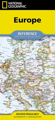
• Waterproof • Tear-Resistant • Reference Map   Expertly researched and designed, National Geographic's Europe Flags & Facts Map is the authoritative map of Europe by which other reference maps are measured. The map side includeds a political map showing countries, cities and other landmarks and a physical map shows the landforms such as mountain ...

Verkopers met dit product

Webshop
Bezorging
Prijs
DeZwerver.nl logo
DeZwerver.nl
niet bekend
17,50

Anderen bekeken ook

Wegenkaart - landkaart Asia - Azië | National Geographic
• Waterproof • Tear-Resistant • Reference Map   Expertly researched and designed, National Geographic's Asia Flags & Facts Map is the authoritative map of Asia by which other reference maps are measured. The map side includeds a political map showing countries, cities and other landmarks and a physical map shows the landforms such as mountain ranges and rivers.   Clearly defined boundaries, major cities, and physical features Hundreds of place names carefully placed to maintain legibility in heavily populated areas Includes Asia including Russia and adjacent regions within Europe and Africa Detailed physical map of Asia with mountain ranges, plains, lakes, and rivers Flags and facts with detailed information about cultural and physcial attributes Printed in the U.S.A. on extremely durable, waterproof, and tear-resistant material This Reference Map is printed on durable synthetic paper, making it waterproof, tear-resistant and tough — capable of withstanding the rigors of any kind of u…
17,50
Wegenkaart - landkaart Africa - Afrika | National Geographic
  • Waterproof • Tear-Resistant • Reference Map   Expertly researched and designed, National Geographic's Africa Flags & Facts Map is the authoritative map of Africa by which other reference maps are measured. The map side includeds a political map showing countries, cities and other landmarks and a physical map shows the landforms such as mountain ranges and rivers.   Clearly defined boundaries, major cities, and physical features Hundreds of place names carefully placed to maintain legibility in heavily populated areas Includes Africa and adjacent regions within Europe and Asia Detailed physical map of Africa with mountain ranges, plains, lakes, and rivers Flags and facts with detailed information about cultural and physcial attributes Printed in the U.S.A. on extremely durable, waterproof, and tear-resistant material This Reference Map is printed on durable synthetic paper, making it waterproof, tear-resistant and tough — capable of withstanding the rigors of any kind of use in the…
17,50
Wegenkaart - landkaart Australia and Oceania | National Geographic
• Waterproof • Tear-Resistant • Reference Map   Expertly researched and designed, National Geographic's Australia and Oceania Flags & Facts Map is the authoritative map of Australia by which other reference maps are measured. The map side includeds a political map showing countries, cities and other landmarks and a physical map shows the landforms such as mountain ranges and rivers. The Flags & Facts side includes an overview map of Oceania, the section of the Pacific Ocean stretching from New Zealand to the Galapagos Islands.   Clearly defined boundaries, major cities, and physical features Hundreds of place names carefully placed to maintain legibility in heavily populated areas Includes Australia and Oceania and adjacent regions of Asia Detailed physical map of Australia with mountain ranges, plains, lakes, and rivers Flags and facts with detailed information about cultural and physcial attributes Printed in the U.S.A. on extremely durable, waterproof, and tear-resistant material T…
17,50
Wegenkaart - landkaart South America and Antarctica | National Geographic
• Waterproof • Tear-Resistant • Reference Map   Expertly researched and designed, National Geographic's South America and Antarctica Flags & Facts Map is the authoritative map of South America by which other reference maps are measured. The map side includeds a political map showing countries, cities and other landmarks and a physical map shows the landforms such as mountain ranges and rivers. The Flags & Facts side includes a combined political and physical map of Antarctica.   Clearly defined boundaries, major cities, and physical features Hundreds of place names carefully placed to maintain legibility in heavily populated areas Includes South America and Antarctica and adjacent regions within North America Detailed physical map of South America with mountain ranges, plains, lakes, and rivers Flags and facts with detailed information about cultural and physcial attributes Printed in the U.S.A. on extremely durable, waterproof, and tear-resistant material This Reference Map is printe…
17,50
Wegenkaart - landkaart North America - Noord Amerika | National Geographic
• Waterproof • Tear-Resistant • Reference Map   Expertly researched and designed, National Geographic's North America Flags & Facts Map is the authoritative map of North America by which other reference maps are measured. The map side includeds a political map showing countries, cities and other landmarks and a physical map shows the landforms such as mountain ranges and rivers.   Clearly defined boundaries, major cities, and physical features Hundreds of place names carefully placed to maintain legibility in heavily populated areas Includes North America and adjacent regions within Asia and South America Detailed physical map of North America with mountain ranges, plains, lakes, and rivers Flags and facts with detailed information about cultural and physcial attributes Printed in the U.S.A. on extremely durable, waterproof, and tear-resistant material This Reference Map is printed on durable synthetic paper, making it waterproof, tear-resistant and tough — capable of withstanding the…
17,50
Wegenkaart - landkaart Jasper National Park (Alberta) | Gem Trek Maps
Waterproof and tear-resistant map for Jasper National Park in the Canadian Rockies.   Whether you are a first-time visitor or a long-time local, you’ll find Gem Trek’s Jasper National Park Map to be an invaluable tool. Researched and designed by locals, and printed in Canada, this map features accurate cartography and subtly colored relief that puts the mountainous region in perspective. The map is printed on high-quality synthetic waterproof paper that can be folded and refolded hundreds of times.   The 1:250,000 scale is ideal for discovering the very best of Jasper National Park. Highlights and our recommended hiking trails are marked by numbered stars, then cross-referenced on the reverse side with descriptions. Also included are all mountains and their elevations, along with natural features such as waterfalls, hot springs, and glaciers.   In addition to descriptions for the top highlights and most popular hiking trails, the reverse side has inset maps for the town of Jasp…
16,95
Nieuw
Wegenkaart - landkaart 3119 California - Nevada | National Geographic
Mooie kaart van de bekende kaartenmaker National Geographic. Veel details door kleurgebruik. De wegen zijn met kleuren verdeeld in drukke en minder drukke, de wegnummers zijn goed terug te vinden. De kaart onderscheidt zich van andere series door de hoeveelheid topografische details als counties, plaatsnamen en waterwegen en het bevat een register waarin het eenvoudig zoeken is. Daarnaast is de kaart gedrukt op scheur- en watervast papier. The United States California and Nevada Adventure Map will guide you through two of the most spectacular and diverse states in the country. California and Nevada contain Yosemite and Sequoia & Kings Canyon National Parks, Death Valley and the Mohave Desert, the Sierra Nevada Mountains, Lake Tahoe, and dozens of magnificent National Monuments, Forests, and Wilderness Areas. The map includes the cities of Los Angeles, San Francisco, San Diego, and Las Vegas as well as the breathtaking Pacific coast of California. It covers western Utah and Arizona, in…
17,50
Wegenkaart - landkaart Motomap Motorkaart Sardinië - Sardinie | Hallwag
Die schönsten Strecken mit Sehenswürdigkeiten und Herbergen. GPS-Daten: Gratis Download der Motorradtouren. Einzeln herausnehmbare Karten mit 16 Roadbooks Sardinia Motorbike Map Set from Hallwag with individual waterproof and tear-resistant maps for 16 day tours, plus an overview road map of the whole island. The tours are from 120 km to 260 km long, and each is prominently highlighted on a separate handy size, 24.5 x 23 cm map extract at 1:275,000, printed on waterproof and tear-resistant synthetic paper. Accompanying information indicates the degree of difficulty, distance and approximate timing, etc, and recommended accommodation. Also provided is a link to the website for downloading GPS coordinates. All the text is in German only.   The accompanying overview map shows all the tours together and covers not just Sardinia but also Corsica and mainland Italy from Turin and Piacenza in the north to Rome in the south, extending eastwards to Ravenna and Perugia. Road network is clearly …
19,50
Wereldkaart Politiek & antiek, pacific centered, 117 x 78 cm | National Geographic
National Geographic's World map is the standard by which all other reference maps are measured. The World map is meticulously researched and adheres to National Geographic's convention of making independent, apolitical decisions based on extensive research using multiple authoritative source.   The Executive style World map uses an antique-style color palette and stunning shaded relief that provide a richness perfect for any decor. The Pacific Centered World map employs a unique view to accentuate the Pacific Rim, and focuses on Oceania and Asia and while showing the entire breadth of the Pacific Ocean. Drawn in a special Winkel Tripel projection, distortions are minimized and unlike many other World maps, Greenland is show the same size as Argentina and not as the size of all of South America.   Thousands of place names are carefully and artistically placed on the map to maintain legibility even in the heavily populated ares of Europe, Asia and the Middle East. Details include clearl…
36,95
Wandkaart Zuidoost Azië, politiek, 96 x 81 cm | National Geographic
The Southeast Asia Political Map is a detailed reference map containing National Geographic’s clear visual presentation in a bright and appealing color palette. The map contains thousand of place names, accurate political boundaries, and infrastructure, making it the perfect reference for student, home, or business.   This detailed wall map of Southeast Asia by National Geographic includes Indonesia, New Guinea, the Phillipines, Malaysia, Thailand, Myanmar, Cambodia and Vietnam. Coverage includes the whole of Indonesia and the Philippines, and extends north to cover China as far as Hangzhou and, in the north-western corner, Bhutan.   Details featured on this Southeast Asia Wall Map include:   • Political Boundaries • Major Cities and Capitals • Physical Terrain Shading • Mountain Ranges, Highest Point • Lakes, Rivers and Waterways • Latitude and Longitude Lines • Basic Bathymetry (Ocean Depths) • Major Airports • National Parks
34,95

Klanten-reviews van Wegenkaart - landkaart Europe - Europa | National Geographic

Er zijn nog geen beoordelingen voor dit productBen jij de eerste die een review plaatst?

Meer over Wegenkaart - landkaart Europe - Europa | National Geographic

Productomschrijving

• Waterproof • Tear-Resistant • Reference Map   Expertly researched and designed, National Geographic's Europe Flags & Facts Map is the authoritative map of Europe by which other reference maps are measured. The map side includeds a political map showing countries, cities and other landmarks and a physical map shows the landforms such as mountain ranges and rivers.   Clearly defined boundaries, major cities, and physical features Hundreds of place names carefully placed to maintain legibility in heavily populated areas Includes Europe including Russia and adjacent regions within Asia and Africa Detailed physical map of Europe with mountain ranges, plains, lakes, and rivers Flags and facts with detailed information about cultural and physcial attributes Printed in the U.S.A. on extremely durable, waterproof, and tear-resistant material This Reference Map is printed on durable synthetic paper, making it waterproof, tear-resistant and tough — capable of withstanding the rigors of any kind of use in the home or classroom.

Verken gerelateerde categorieën

Webshop.nl maakt gebruik van cookies. Ga je verder op onze website, ga dan akkoord met het plaatsen van cookies en de verwerking van deze data door ons en vermelde partners.