webshop.nl
Categorieën
  Sluiten

Meer ITMB

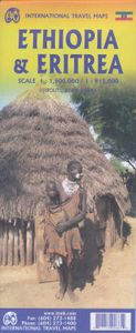
Wegenkaart - landkaart Ethiopia Ethiopië - Eritrea | ITMB

Een degelijke kaart met aanduidingen van o.a. nationale parken, vliegveld, benzinepomp, dirt-roads en kleine plattegrond van hoofdstad. Als overzichtskaart goed te gebruiken. This is the latest updating of one of the most interesting countries in Africa. There isn’t anything brilliantly innovative to report. We have tidied up the different layers o...
13,95

Webshops met dit product

Webshop
Bezorging
Prijs

Anderen bekeken ook

Wegenkaart - landkaart Ethiopia Ethiopië - Eritrea | ITMB
Een degelijke kaart met aanduidingen van o.a. nationale parken, vliegveld, benzinepomp, dirt-roads en kleine plattegrond van hoofdstad. Als overzichtskaart goed te gebruiken. This is the latest updating of one of the most interesting countries in Africa. There isn’t anything brilliantly innovative to report. We have tidied up the different layers of the artwork, have updated the road system, and have added more tourist information. We have also modernized the cover design and changed the ISBN – printed on paper, single-sided, inset map of Addis Ababa. Legend Includes: roads by classification, Airports, Ports, Gasolines, Polices, Post Offices, Bus Stations, Hospitals, Schools, Universities, Buildings, Point of Interests, Bridges, Lodgings, Campsites or Huts, Museums, and many more   Double-sided map from ITMB presenting on one side a road map of Ethiopia at 1:2,000,000 accompanied by a street plan of Addis Ababa, with on the reverse Eritrea at 1:900,000 with a plan of Asmara. Both road…
13,95
Reisgids Ethiopia, Djibouti - Ethiopië | Lonely Planet
De perfecte reisgids voor zowel de georganiseerde als de zelfstandige reiziger. Naast een algemene inleiding van het land / streek vol met praktische informatie over hoe je er het beste kunt reizen: slapen, eten, vervoer, excursies ... alles kun je er in vinden. Engelstalig. Lonely Planet Lonely Planet Ethiopia & Djibouti is your passport to the most relevant, up-to-date advice on what to see and skip, and what hidden discoveries await you. Explore underground churches in Lalibela, spot rare and beautiful animals in the Bale Mountains, or get to know Ethiopian cuisine in Addis Ababa; all with your trusted travel companion. Get to the heart of Ethiopia and Djibouti and begin your journey now!   Inside Lonely Planet Ethiopia & Djibouti Travel Guide:   Colour maps and images throughout Highlights and itineraries help you tailor your trip to your personal needs and interests Insider tips to save time and money and get around like a local, avoiding crowds and trouble spots Essential…
23,95
Wegenkaart - landkaart Gambia & Senegal | ITMB
Een degelijke kaart met aanduidingen van o.a. nationale parken, vliegveld, benzinepomp, dirt-roads en kleine plattegrond van hoofdstad. Als overzichtskaart goed te gebruiken. Gambia schaal 1:340.000 Senegal schaal 1:740.000 We combined Senegal with Gambia in this edition, but as two completely separate maps - Senegal on one side, and Gambia on the other. During our recent research trip to the two countries, it became obvious to us that the two countries are so inter-linked that it doesn't make sense to show one without the other. This new map has two covers, so the map can be displated Gambia side outwards, or Senegal side outwards. Both maps benefit from improved availability of information, thanks to our visit. Frankly, neither country appears to have progressed significantly over the past 40 years since my first visit, but I'm a cynic. The main east-west highways in both countries are being paved (again) by European countries providing foreign aid (again). No road mainenance camps a…
13,95
Wandkaart Africa - Afrika Zuid | 98 x 130 | Tracks4Africa
Our AFRICA WALL MAP is printed at a scale of 1:4 million and laminated on both sides. The size of the final map is 1300 X 980 mm.   The map includes countries from South Africa in the south to Ethiopia in the north.   Perfect for macro planning of self-drive trips through Southern and Eastern Africa and even to West Africa up to Gabon.   Printed in full colour, all major and secondary roads are shown with national parks and country borders clearly visible.   The Tracks4Africa Wall Map is printed to a scale of 1:4million and provides a surprising amount of detail to the self-drive traveller.  The map is perfect for macro planning of extended road trips across the African continent up to Ethiopia in the east and Gabon in west.  The map indicates major and secondary roads, parks, towns and a good number of tracks in remote areas.  Major tourist attractions are indicated  where space allows for it. International airports and country borders suitable for vehicle crossings are indicated.  …
89,95
Wegenkaart - landkaart Mauritania & Mali | ITMB
Een degelijke kaart met aanduidingen van o.a. nationale parken, vliegveld, benzinepomp, dirt-roads en kleine plattegrond van hoofdstad. Als overzichtskaart goed te gebruiken. Mali 1:1.900.000 Mauretanië 1:2.200.000 In this edition, we have combined Mauritania with Mali. Although both are interesting countries, the two fit naturally together as a unit, albeit at slightly differing scales. Technically, this should be a 1st edition map, as it is the first time we have combined these two desert countries on to one sheet, but I ll let Robert at the Library of Congress worry about the niceties of bibliographic accuracy as soon as Trump allows him to do the work he loves for a salary. Mauritania was one of the most unusual countries I visited as a young traveller. Of course, I had an advantage, in that I was too young to know that what I was doing was supposed to be impossible. I entered from what was then the Spanish Sahara via a piste (a sandy track with multiple pathways, only some of whic…
13,95
Wandkaart Africa - Afrika Zuid | 98 x 130 | Tracks4Africa
Our AFRICA WALL MAP is printed at a scale of 1:4 million and laminated on both sides. The size of the final map is 1300 X 980 mm.   The map includes countries from South Africa in the south to Ethiopia in the north.   Perfect for macro planning of self-drive trips through Southern and Eastern Africa and even to West Africa up to Gabon.   Printed in full colour, all major and secondary roads are shown with national parks and country borders clearly visible.   The Tracks4Africa Wall Map is printed to a scale of 1:4million and provides a surprising amount of detail to the self-drive traveller.  The map is perfect for macro planning of extended road trips across the African continent up to Ethiopia in the east and Gabon in west.  The map indicates major and secondary roads, parks, towns and a good number of tracks in remote areas.  Major tourist attractions are indicated  where space allows for it. International airports and country borders suitable for vehicle crossings are indicated.  …
89,95
Wegenkaart - landkaart Kyrgyzstan and Tajikistan | ITMB
This is a new title for ITMB. The two Central Asian countries of Kyrgyzstan and Tajikistan are rapidly developing a touristic market and we feel that the world needs a good map to reflect their growing importance. The two ‘stans were part of the Soviet empire that fell apart in 1990, creating a dozen new countries. This double-sided map covers Kyrgyzstan on one side, with an inset map of its capital, Bishkek. The main attractions are Osh and Suyab, both ancient market centres on the Silk Road, and Lake Issyk-Kul, the world’s second largest alpine lake. The reverse side concentrates on Tajikistan mountainous country just west of the Himalayas, with an inset of its capital, Dushanbe. Both of these countries should be considered ‘adventure’ destinations.
13,95
Wegenkaart - landkaart Paraguay & Bolivia South | ITMB
Een degelijke kaart met aanduidingen van o.a. nationale parken, vliegveld, benzinepomp, dirt-roads en kleine plattegrond van hoofdstad. Als overzichtskaart goed te gebruiken. Technically, this is a new title for ITMB, in that it is not merely an updating of a previous edition, but it is still a map of Paraguay, basically, so we count it as an updated edition with part of Bolivia included. Expanding the area of coverage benefits visitors combining Paraguay and Bolivia into one trip. The first side covers Bolivia from La Paz south to the Paraguayan border, with inset maps of Potosi and Santa Cruz. The second side concentrates on Paraguay itself, with inset maps of Asuncion, the Asuncion region, and northern Paraguay. Small bits of bordering countries also are included. Road connections within Paraguay have been shown to good advantage. Both countries, being land-locked, are somewhat isolated, making travel to them something more adventuresome than visits to neighbouring countries. Howeve…
13,95
Wegenkaart - landkaart Rwanda & Burundi | ITMB
Een degelijke landkaart van Rwanda & Burundi met aanduidingen van o.a. nationale parken, vliegveld, benzinepomp, dirt-roads en kleine plattegrond van hoofdstad. Als overzichtskaart goed te gebruiken. The two central African countries of Rwanda and Burundi are gradually returning to prosperity. They are both very interesting countries, scenically attractive, and relatively untouched by modernism. Both have suffered serious unrest in the past, but have moved on and are determined to have a bright and happy future. The people are marvelous; one can’t express in a brief paragraph the warmth and friendliness of the ordinary people of both countries. This is really a part of Africa everyone should visit. It’s a very special place, and I’m pleased to introduce the latest edition of an excellent map for two of my favourite places. As with past editions, this is actually two completely separate maps, with Rwanda on one side and Burundi on the other. There are two different covers, so the map ca…
13,95

Klanten-reviews van Wegenkaart - landkaart Ethiopia Ethiopië - Eritrea | ITMB

Er zijn nog geen beoordelingen voor dit productBen jij de eerste die een review plaatst?

Meer over Wegenkaart - landkaart Ethiopia Ethiopië - Eritrea | ITMB

Productomschrijving

Een degelijke kaart met aanduidingen van o.a. nationale parken, vliegveld, benzinepomp, dirt-roads en kleine plattegrond van hoofdstad. Als overzichtskaart goed te gebruiken. This is the latest updating of one of the most interesting countries in Africa. There isn’t anything brilliantly innovative to report. We have tidied up the different layers of the artwork, have updated the road system, and have added more tourist information. We have also modernized the cover design and changed the ISBN – printed on paper, single-sided, inset map of Addis Ababa. Legend Includes: roads by classification, Airports, Ports, Gasolines, Polices, Post Offices, Bus Stations, Hospitals, Schools, Universities, Buildings, Point of Interests, Bridges, Lodgings, Campsites or Huts, Museums, and many more   Double-sided map from ITMB presenting on one side a road map of Ethiopia at 1:2,000,000 accompanied by a street plan of Addis Ababa, with on the reverse Eritrea at 1:900,000 with a plan of Asmara. Both road maps are indexed and show the topography by altitude colouring: in Ethiopia with bands in metres and peak heights given in both metres and feet, and in Eritrea with bands in feet and peak heights either in feet and metres or in feet only.   Road network indicates unpaved roads and seasonal tracks, with driving distances shown on main routes. Also marked in both countries are locations of petrol stations and border crossings. The map indicates local airports and landing grounds and in Ethiopia railway lines are shown. Symbols highlight various places of interest. Latitude and longitude lines are drawn at 1º intervals. Each country has a separate index.   Street plans of Addis Ababa and Asmara highlight various places of interest including selected hotels and other tourist facilities. The map also includes notes on the history, geography, etc, of both countries.

Productspecificaties

Artikelnummer(s)
Brand
ITMB
Webshop.nl maakt gebruik van cookies. Ga je verder op onze website, ga dan akkoord met het plaatsen van cookies en de verwerking van deze data door ons en vermelde partners.