Wegenkaart - landkaart Ecuador | ITMB

0
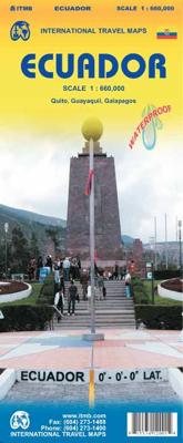
Duidelijke wegenkaart van Ecuador, aan 2 zijden bedrukt. Met stadsplattegronden van Quito, Guayaquil. Aanduidingen van benzinestations, Nationale parken en bezienswaardigheden. Very detailed, double sided travel map of Ecuador shows road network and physical features. Distances between communities are shown, as well as gas stations outside of majo...

Verkopers met dit product

Verkoper
Bezorging
Prijs
DeZwerver.nl logo
DeZwerver.nl
2,95
13,95

Anderen bekeken ook

Stadsplattegrond - Wegenkaart - landkaart Quito & Ecuador Central | ITMB
Een degelijke wegenkaart van Ecuador met aanduidingen van o.a. nationale parken, vliegveld, benzinepomp, dirt-roads en kleine plattegrond van hoofdstad. Als overzichtskaart goed te gebruiken. Finally, ITMB releases its long-awaited re-worked map of the wonderful South America city of Quito. The city is squeezed in between mountain ranges and, the entire city stretches from north (on the right-hand side of the map) to the south. The "bottom" of the map is, actually the eastern portion. A regional inset map clarifies the situation. The street network is clearly shown, along with the rapid line bus way and the city's Metro. The Old Town is perhaps the most interesting portion of the city for visitors and is on the left-hand portion of the map. The newer downtown is centered on La Carolina Park on the right-hand side of the map. This is where most of the shopping malls and hotels are located. The old airport is shown in part on the far right, but the new international airport is located f…
13,95
Wegenkaart - landkaart Ecuador | Borch
Mooie geplasticieerde kaart van Ecuador. Deze kaart biedt een goed overzicht van het land met detailkaarten.   Our soft-laminated folded map of Ecuador shows: Ecuador West 1:1 000 000, Ecuador Est 1:2 000 000, Galapagos Islands1:1 300 000, Gran Quito 1:100 000, Quito 1:20 000, Cuenca 1:17 000, Guayaquil 1:18 000, Ecuador administrative and times zones. Borch maps are easy to fold, durable and water-repellent with a wipeable surface. Borch Maps show hotels, museums, monuments, markets, public transport, top sights and points of interest, useful statistics, conversion charts for temperatures, weights and measurements, climate charts showing temperatures, sunshine hours, precipitation and humidity, overview maps, time zones, and much more...   Dominated by the towering Andean range, Ecuador is a country of magnificent highlands, dramatic slopes, dense rainforests, fertile lowlands and tranquil sandy beaches. Its immense variety of landscapes and habitats support a unique flora and fauna …
11,50
Wegenkaart - landkaart The Andes | ITMB
Een degelijke wegenkaart van de hele Andes met aanduidingen van o.a. nationale parken, vliegveld, Als overzichtskaart goed te gebruiken. We are pleased to be able to re-introduce this important title into our publishing range after a lapse caused by Covid. The Andes mountain chain is the southern extension of the Sierra Nevada chain through Mexico and Central America, which is, in turn the southern extension of the Rocky Mountain chain from Alaska to the Mexican border. The Andes is a magnificent series of high mountains that enters Colombia and spreads southwards through Ecuador and Peru all the way to southern Patagonia. The map is double-sided, with the Northern Andes on one side and the other side divided into two side-by-side maps portraying the Central Andes and the Southern Andes. Thus, the map coverage focuses on the Andes themselves, rather than on all of South America. All of Colombia and Peru are shown, most of Bolivia, all of Chile, and the Patagonian portion of Argentina …
13,95
Wegenkaart - landkaart 3403 Adventure Map Ecuador & Galapagos | National Geographic
Wegenkaart van Galapagos en Ecuador met vermelding van veel bezienswaardigheden, nationale parken en attrakties. Watervast en scheurvast. Juist door deze vermeldingen onderscheidt de kaart zich van andere wegenkaarten. National Geographic's Ecuador and Galapagos Adventure Map is designed to meet the unique needs of adventure travelers—detailed, durable, and accurate. Ecuador and Galapagos includes the locations of thousands of towns and villages, plus a clearly marked road network complete with distances and designations for highways, roads and more.   What sets National Geographic Adventure Maps apart from traditional road maps are the hundreds of points of interest that highlight the diverse, unique, and exotic destinations within Ecuador and the Galapagos islands including national parks and reserves, World Heritage sites, archeological sites, churches, spas, and more.   The front side of the map shows the southern half of Ecuador including the provinces of Zamora, Chinchipe, Loja,…
17,50
Wegenkaart - landkaart Yemen - Jemen | Gizi Map
Yemen, including the Gulf of Aden, at 1:1,250,000 on an excellent and informative map from Gizi Maps, with a street plan of central Sana’a and enlargements of the environs of the capital and Aden, plus the Aden Peninsula.   The map has the publisher’s characteristic bold altitude colouring and plenty of names of various mountain chains, peaks, deserts, etc. Graphics indicate swamps, salt flats, wadis, deserts, lava flows, water wells, oasis, etc, to provide a vivid picture of the country’s topography. Names of the larger towns, provinces and many geographical features are given in both Latin and Arabic alphabets; all other place names are shown only transliterated.   Coverage extends southward to the northern coastline of the Horn of Africa, including the whole of Djibouti and most of Eritrea. Within the Gulf of Aden the Internationally Recommended Transit Corridor (IRTC) is marked, as well as other ferry and shipping routes including those leading to the Socotra Archipelago and in th…
15,95
Wegenkaart - landkaart China | ITMB
Een degelijke kaart met aanduidingen van o.a. nationale parken, vliegveld, benzinepomp, dirt-roads en kleine plattegrond van hoofdstad. Als overzichtskaart goed te gebruiken. Tweezijdig, op de ene kant West China en op de andere zijde Oost China. This edition is printed on waterproof, tear-resistant paper, and has a new cover picture showing a portion of the Great Wall. A cursory glance at the map will show an incredible number of motorways. We still show some as being under construction, but updating the road network is now essentially completed. The amazing rapid rail network is now also essentially complete and all such train lines are noted on the map in a red-dashed format. Inset maps of Beijing and Shanghai are shown on side 2, as well as a list of Top Attractions. We continue to show contentious political disputed territories based on practical administrative control, so India's northeast is shown as being under India's control, whereas parts of the northwest are shown under Ch…
13,95
Wegenkaart - landkaart Mekong Delta & Southern Vietnam | ITMB
Een degelijke kaart met aanduidingen van o.a. nationale parken, vliegveld, benzinepomp en dirt-roads. Als overzichtskaart goed te gebruiken. Double-sided indexed map with street plans of central Ho Chi Min City, Da Lat and Can Tho. The main map at 1:800,000 shows the area’s road and rail networks and local airports. The Ho Chi Minh Trail is highlighted, as are national parks, nature reserves, beaches, numerous places of interest, fuel supplies, etc. Provincial boundaries are marked and names of administrative regions prominently shown. Topography is indicated by altitude colouring. Latitude and longitude lines are drawn at 30’ intervals. On the reverse, the Mekong Delta is shown in greater detail at 1:500,000 with many small waterways. The map also includes street plans of central Ho Chi Minh City, Can Tho and Da Lat, annotated with symbols showing accommodation, various facilities and places of interest. Further insets show Phu Quoc Island at 1:200,000 and, for travelers venturing fu…
13,95
Wegenkaart - landkaart Maui, Kauai, & Molokai | ITMB
At long last, we have finally found time to complete our detailed mapping of the American state of Hawaii. The island of Maui may not be at well-known as Oahu, which is extremely popular with Japanese honeymooners, but it is as attractive touristically. Our coverage covers most of Side 1 and includes a detailed inset map of Wailuku, the principal urban area, as well as insets of Lahaina on the west coast and Wailea resort area. This side also includes a map of the island of Lanai, with its main urban area of Lanai City as an inset. Side 2 concentrates on the islands of Molokai, Kauai, and the lightly populated island of Ni’ihau, and includes detailed inset maps of Lihue, Kaunakakai, and Po’ipu, all of which are major resort destinations. The islands are loaded with beaches and places to stay, but also with attractions, which are shown on the map. This is a beautiful map, one of the best we have ever produced, and is a fitting companion to our maps of Big Island, and Oahu/Honolulu, as …
13,95
Reisgids Ecuador and Galapagos islands | Rough Guides
Zeer goede reisgids voor zowel de georganiseerde maar vooral voor de zelfstandige reiziger. Boordevol informatie over reizen, slapen, eten, maar ook musea en cultuur. Uitputtende bron van informatie, veelal nog completer dan de Lonely Planet. Inleidende informatie over land en cultuur is zeer goed. Discover Ecuador and the Galápagos Islands with this comprehensive, entertaining, ‘tell it like it is’ Rough Guide, packed with comprehensive practical information and our experts’ honest and independent recommendations.   Whether you plan to take in the colonial architecture of Cuenca or stroll along Guayaquil’s Malecón 2000, relax in the spa town of Baños or climb a volcano, The Rough Guide to Ecuador and the Galápagos Islands will help you discover the best places to explore, sleep, eat, drink and shop along the way.   Features of The Rough Guide to Ecuador and the Galápagos Islands: – Detailed regional coverage: provides in-depth practical information for each step of all kinds of…
25,95
Wegenkaart - landkaart Peru | ITMB
Een degelijke kaart met aanduidingen van o.a. nationale parken, vliegveld, dirt-roads en kleine plattegrond van hoofdstad. Als overzichtskaart goed te gebruiken. Peru at 1:1,500,000 on a double-sided, waterproof and tear-resistant, indexed map from ITMB, with large, clear street plans of central Lima and Cusco, highlighting accommodation, places of interest and various facilities. The map divides the country north/south, approximately along the line between the Cordillera Blanca and Cordillera Huyahuash, with very little overlap between the two sides. Topography is very effectively presented by altitude colouring, with spot heights and additional graphics for swamps and marshland, glaciers and volcanos. The map shows the country’s road network distinguishing between all-weather and seasonable roads and indicates driving distances on main routes. Railway lines, including the popular routes linking Cusco with Puno and Arequipa, are very clearly shown. The map also shows local airports a…
13,95

Klanten-reviews van Wegenkaart - landkaart Ecuador | ITMB

Er zijn nog geen beoordelingen voor dit productBen jij de eerste die een review plaatst?

Meer over Wegenkaart - landkaart Ecuador | ITMB

Productomschrijving

Duidelijke wegenkaart van Ecuador, aan 2 zijden bedrukt. Met stadsplattegronden van Quito, Guayaquil. Aanduidingen van benzinestations, Nationale parken en bezienswaardigheden.

Very detailed, double sided travel map of Ecuador shows road network and physical features. Distances between communities are shown, as well as gas stations outside of major towns. National parks and points of interest are also shown. Includes an inset map of Quito and Environs of Guayaquil as well as a comprehensive place name index. Printed on waterproof synthetic paper suitable for tropical conditions.

Productinformatie

    Verken gerelateerde categorieën

    Webshop.nl maakt gebruik van cookies. Ga je verder op onze website, ga dan akkoord met het plaatsen van cookies en de verwerking van deze data door ons en vermelde partners.