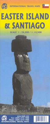

Wegenkaart - landkaart Easter Island - Paaseiland en Santiago | ITMB

0
Easter Island is so isolated that it is not certain whether it is part of Polynesia or an off-shoot of South America. Geologically, it is neither; just a volcanic lump in the vast expanse of the Pacific Ocean. Its original inhabitants probably came from Polynesia; since supplanted by migrants from Chile, which is the political authority governing ...

Alle aanbiedingen van dit product

Verkoper
Bezorging
Prijs
DeZwerver.nl logo
DeZwerver.nl
2,95
14,95

Anderen bekeken ook

Wegenkaart - landkaart Easter Island - Paaseiland en Santiago | ITMB
Easter Island is so isolated that it is not certain whether it is part of Polynesia or an off-shoot of South America. Geologically, it is neither; just a volcanic lump in the vast expanse of the Pacific Ocean. Its original inhabitants probably came from Polynesia; since supplanted by migrants from Chile, which is the political authority governing the island. Regardless, it is an intriguing place, famous for the Maoi - giant heads originally raised to protect family holdings. These huge, mysterious heads rest in various locations on the island and are one of the wonders of the world. This map also includes a detailed map of Santiago de Chile, the capital of Chile, for the simple reason that all flights to Easter Island originate in that city, so everyone going to Easter Island needs a map of Santiago as well. This usage is merely for the convenience of visitors going to Easter Island. ITMB publishes a separate map of Santiago and Central Chile and we intend to continue to do so.   Lege…
14,95
Reisgids Chile & Easter Island - Chili en Paaseiland | Insight Guides
Een rijk geillustreerde reisgids  voor Chili en Paaseiland, met diepgaande teksten: één van de beste reisgidsen die er bestaan. Eerste deel bestaat uit een beschrijving van de unieke aspecten van de regio, daarna een deel echte reisgids en als afsluiting een deel met praktische informatie. De uitstekende informatie wordt vergezeld van prachtige foto's en heldere kaarten. Niet alleen om mee te nemen, maar ook om vooraf en zelfs achteraf weer in de stemming te komen. This Chile & Rapa Nui (Easter Island) guidebook is ideal for travellers seeking inspirational guides and planning a more extended trip. It provides interesting facts about Chile & Rapa Nui (Easter Island)'s people, history and culture and detailed coverage of the best places to see. This Chile & Rapa Nui (Easter Island) travel book has the style of an illustrated magazine to inspire you and give a taste of Chile & Rapa Nui (Easter Island).   The book is printed on paper from responsible sources, and verified to meet FSC…
24,95
Reisgids Chile & Easter Island - Chili en Paaseiland | Lonely Planet
De perfecte reisgids voor zowel de georganiseerde als de zelfstandige reiziger. Naast een algemene inleiding van het land / streek vol met praktische informatie over hoe je er het beste kunt reizen: slapen, eten, vervoer, excursies ... alles kun je er in vinden. Engelstalig. Lonely Planet Lonely Planet's local travel experts reveal all you need to know to plan the trip of a lifetime in this latest edition of our guide to Chile & Rapa Nui (Easter Island).   Discover Chile & Rapa Nui (Easter Island)'s most popular experiences and best kept secrets from surfing one of the most famous waves in the Americas, the perfect left break at Punta de Lobos; to catching a mind-melting sand dune sunset of surreal purples, pinks and yellows at Valle de la Luna; and visiting the most opulent wineries in Chile's Colchagua Valley.   Build a trip to remember with Lonely Planet's Chile & Rapa Nui (Easter Island) travel guide:   Our classic guidebook format contains the most comprehensive level of…
26,50
Wegenkaart - landkaart Patagonië en Zuid Chili - Patagonia - Chile south | ITMB
Een degelijke wegenkaart met aanduidingen van o.a. nationale parken, vliegveld, benzinepomp, dirt-roads. Als overzichtskaart goed te gebruiken.   Zuid Chili schaal 1:1.770.000 Patagonië schaal 1:2.200.000   This is a brand new map for ITMB and concentrates on the fast-changing southern portion of Chile (known as the Austral) and Patagonia, which technically only exists in southern Argentina, but in reality can't be shown easily on a map without including the same area in Chile. Thus, one side concentrates on Chile south of Los Angeles (yes, there's one there too!) in two long strip maps that go all the way to Cape Horn (or Hoorn, in Dutch) south of Tierra del Fuego. Although it has nothing to do with this part of Chile, we have also included the main portion of touristic Easter Island, an inset of what is popularly referred to as Robinson Crusoe Island (Alexander Selkirk was marooned here for a number of years, and is the real-life model of the fictional Crusoe) and an inset map of Us…
14,95
Wegenkaart - landkaart Indonesië - Indonesia | ITMB
Een degelijke landkaart van Indonesië met aanduidingen van o.a. nationale parken, vliegvelden en grote wegen. Als overzichtskaart goed te gebruiken. De nadruk ligt echter vooral op de natuurkundige aspecten. Scheur- en watervast! Met een kleine kaart van Jakarta. The hundreds of islands making up the island nation of Indonesia make a double-sided map inevitable in order to show any significant amount of detail. Side 1 shows the western half, starting with Sumatra in the upper left and including Java and most of the island of Borneo (Kalimantan Province to the Indonesians). This side also includes a large inset map of central Jakarta (for better detail see our separate map of the city); ditto for Sumatra, Java, and Borneo. Bali, Lombok, and Sumbawa islands are in the lower right portion of the map, and most of Malaysia and all of Singapore are included, simply because they are there. The infamous volcanic island of Krakatoa is located just to the west of Java. The other side of the map…
14,95
Wegenkaart - landkaart Chile - Chili | Borch
Mooie geplasticieerde kaart van Chili. Deze kaart biedt een goed overzicht van het land met detailkaarten. Our soft-laminated folded map of Chile shows: Northern Chile, Central Chile, Southern Chile & Patagonia 1:2 000 000, Torres del Paine National Park 1:240 000, Robinson Crusoe Island 1:200 000, Easter Island (Rapa Nui) 1:160 000, Punta Arenas, Antofagasta, Iquique 1:15 000, Valparaiso 1:10 000, Arica 1:16 000, La Serena 1:13 000, Vina del Mar 1:22 000, Santiago 1:20 000 and Chile administrative & time zones. Borch Maps are easy to fold, durable and water-repellent with a wipeable surface. Borch Maps show hotels, museums, monuments, markets, public transport, top sights and points of interest, useful statistics, conversion charts for temperatures, weights and measurements, climate charts showing temperatures, sunshine hours, precipitation and humidity, overview maps, time zones, and much more...   The Republic of Chile is a long and narrow coastal strip on the western side of the S…
11,95
Wegenkaart - landkaart Madagascar | ITMB
Een degelijke kaart met aanduidingen van o.a. nationale parken, vliegveld, benzinepomp, dirt-roads en kleine plattegrond van hoofdstad. Als overzichtskaart goed te gebruiken. Tweezijdig! IThe large island off the east coast of Africa is Madagascar. The actual name of the country is the Malagasy Republic, but the public is much more likely to know the country by its island name, so we call our map by the island’s name, rather than using the country name. Makes sense to us! Regardless, this is a major touristic destination. The double-sided map covers the island in great detail, with an inset map of the capital city, Antananarivo. As with other ITMB maps, this one includes a listing of ‘must see’ attractions, such as Tsingy National Park and the famous Lemur’s Park. The island also has a regular surface route to the Comoro Islands, which are also included on this map. Legend Includes: Railroads, Forest, Mational Park, International Airport, Domestic Airport, Fort, holtel, Cave, Museum, …
14,95
Wegenkaart - landkaart Auckland & North Island - Nieuw Zeeland | ITMB
Scale 1:12,500/1:950,000, This new ITMB map should really be called Auckland, Wellington, Christchurch and the North Island of New Zealand, but that’s too long a title. However, in addition to Auckland, the cities of Wellington and Christchurch are included on one side of the map (NZ urban areas don’t tend to be huge). The other side is a very detailed map of North Island, the main island of the country. This map will be perfect for both finding one’s way around Auckland’s waterfront and for exploring the highways and byways, communing with woolies; printed double-sided on paper
14,95
Wegenkaart - landkaart Bermuda | ITMB
Een degelijke kaart met aanduidingen van o.a. nationale parken, vliegveld, benzinepomp, dirt-roads. Als overzichtskaart goed te gebruiken. Bermuda is a lovely mid-Atlantic island far off the coast of South Carolina. It is full of colonial architecture and an ‘island’ way of life. Tourism is a key ingredient of the colony’s lifeblood and the island is very popular with cruise ships. There is ample accommodation for longer-term visitors, good roads, and much history. The airport was built by the US Navy during WW2 and is still a US Naval Air Station, but shares the runway with civil aviation. The map includes an excellent inset of St. George’s, which still has its stocks close to the town hall, and another of Hamilton, the capital. This is where most cruise ships dock. For those with the time, the map shows the Railway Trail along the former route of the island’s now-defunct rail line. Lots to see; lots to do!   Map size: 27*39"   Legend Includes: Roads by classification, Rivers and Lak…
14,95

Klanten-reviews van Wegenkaart - landkaart Easter Island - Paaseiland en Santiago | ITMB

Er zijn nog geen beoordelingen voor dit productBen jij de eerste die een review plaatst?

Meer over Wegenkaart - landkaart Easter Island - Paaseiland en Santiago | ITMB

Productomschrijving

Easter Island is so isolated that it is not certain whether it is part of Polynesia or an off-shoot of South America. Geologically, it is neither; just a volcanic lump in the vast expanse of the Pacific Ocean. Its original inhabitants probably came from Polynesia; since supplanted by migrants from Chile, which is the political authority governing the island. Regardless, it is an intriguing place, famous for the Maoi - giant heads originally raised to protect family holdings. These huge, mysterious heads rest in various locations on the island and are one of the wonders of the world. This map also includes a detailed map of Santiago de Chile, the capital of Chile, for the simple reason that all flights to Easter Island originate in that city, so everyone going to Easter Island needs a map of Santiago as well. This usage is merely for the convenience of visitors going to Easter Island. ITMB publishes a separate map of Santiago and Central Chile and we intend to continue to do so.   Legend Includes: Roads by classification, Rivers and Lakes, National Park, Airports, Points of Interests, Mining, Highways, Main Roads, Zoos, Fishing, , and much more...

Productinformatie

    Verken gerelateerde categorieën

    Webshop.nl maakt gebruik van cookies. Ga je verder op onze website, ga dan akkoord met het plaatsen van cookies en de verwerking van deze data door ons en vermelde partners.