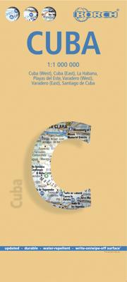
Wegenkaart - landkaart Cuba | Borch

0
Mooie geplasticieerde kaart van Cuba. Deze kaart biedt een goed overzicht van het land met detailkaarten. Our soft-laminated map of Cuba includes: Cuba West 1:1 000 000, Cuba East 1:1000 000, La Habana 1:16 000, Varadero 1:25 000, Playas del Este 1:22 000, Santiago de Cuba 1:16 000, Cuba administrative & time zones. Borch Maps are easy to fold, du...

Verkopers met dit product

Verkoper
Bezorging
Prijs
DeZwerver.nl logo
DeZwerver.nl
2,95
11,50

Anderen bekeken ook

Nieuw
Wegenkaart - landkaart India Noord | Borch
Mooie geplasticieerde kaart van het noorden van India. Deze kaart biedt een goed overzicht van het land met detailkaarten.   Our soft-laminated folded map of India North shows: India North 1:3 000 000, Delhi 1:30 000, Mumbai 1:30 000, Kolkata 1:30 000, Jaipur 1:30 000, Agra 1:30 000, Varanasi 1:30 000, Amritsar 1:30 000, Jodhpur 1:30 000, Udaipur 1:30 000, Bodhgaya 1:15 000 and India administrative and time zones. Borch maps are easy to fold, durable and water-repellent with a wipeable surface. Borch Maps show hotels, museums, monuments, markets, public transport, top sights and points of interest, useful statistics, conversion charts for temperatures, weights and measurements, climate charts showing temperatures, sunshine hours, precipitation and humidity, overview maps, time zones, and much more...   Northern India is bordered by Pakistan to the west, China, Nepal and Bhutan to the north, and Bangladesh and Myanmar to the east. Hindi and English are the two official languages. After…
11,50
Nieuw
Wegenkaart - landkaart India Zuid | Borch
Mooie geplasticieerde kaart van het zuiden van india. Deze kaart biedt een goed overzicht van het land met detailkaarten. Our soft-laminated folded map of India South shows: India South 1:3 000 000, Mumbai 1:30 000, Kolkata 1:30 000, Chennai 1:30 000, Hyderabad 1:30 000, Bengaluru 1:30 000, Old Goa 1:15 000, Madurai 1:30 000, Trivandrum 1:30 000, Hampi 1:30 000, Kochi 1:30 000 and India administrative and time zones. Borch maps are easy to fold, durable and water-repellent with a wipeable surface. Borch Maps show hotels, museums, monuments, markets, public transport, top sights and points of interest, useful statistics, conversion charts for temperatures, weights and measurements, climate charts showing temperatures, sunshine hours, precipitation and humidity, overview maps, time zones, and much more...   Southern India, bordered by the Arabian Sea, the Indian Ocean, and the Bay of Bengal, is a culturally diverse region evoking images of colourful, chaotic cities, Ayurveda retreats, d…
11,50
Nieuw
Wegenkaart - landkaart Hawaiian Islands - Hawaiï | Borch
Mooie geplasticieerde kaart van Hawaiï. Deze kaart biedt een goed overzicht van deze eilanden met detailkaarten.   Our soft-laminated folded map of Hawaii shows: Hawaii (Big Island) 1:400 000, Kilauea Caldera 1:150 000, Hilo 1:70 000, Maui, Molokai / Lanai / Kahoolawe 1:200 000, Wailuku & Kahului 1:35 000, Hawaiian Islands 1:4 000 000, Niihau 1:400 000, Kauai / Oahu 1:200 000, Honolulu & Pearl Harbour 1:26 000, Honolulu Downtown 1:15 500, USA administrative & time zones. Borch Maps are easy to fold, durable and water-repellent with a wipeable surface. Borch Maps show hotels, museums, monuments, markets, public transport, top sights and points of interest, useful statistics, conversion charts for temperatures, weights and measurements, climate charts showing temperatures, sunshine hours, precipitation and humidity, overview maps, time zones, and much more...   Borne of fire and water barely 300 million years ago, the eight islands of the Hawaiian Archipelago together form the 50th US s…
11,50
Nieuw
Wegenkaart - landkaart Chile - Chili | Borch
Mooie geplasticieerde kaart van Chili. Deze kaart biedt een goed overzicht van het land met detailkaarten. Our soft-laminated folded map of Chile shows: Northern Chile, Central Chile, Southern Chile & Patagonia 1:2 000 000, Torres del Paine National Park 1:240 000, Robinson Crusoe Island 1:200 000, Easter Island (Rapa Nui) 1:160 000, Punta Arenas, Antofagasta, Iquique 1:15 000, Valparaiso 1:10 000, Arica 1:16 000, La Serena 1:13 000, Vina del Mar 1:22 000, Santiago 1:20 000 and Chile administrative & time zones. Borch Maps are easy to fold, durable and water-repellent with a wipeable surface. Borch Maps show hotels, museums, monuments, markets, public transport, top sights and points of interest, useful statistics, conversion charts for temperatures, weights and measurements, climate charts showing temperatures, sunshine hours, precipitation and humidity, overview maps, time zones, and much more...   The Republic of Chile is a long and narrow coastal strip on the western side of the S…
11,50
Nieuw
Wegenkaart - landkaart Ireland - Ierland | Borch
Mooie geplasticieerde kaart van Ierland. Deze kaart biedt een goed overzicht van het land met detailkaarten.   Our soft-laminated folded map of Ireland shows: Ireland 1:700 000, Dublin 1:15 000, Cork 1:8 000, Killarney National Park 1:100 000, Wicklow Mountains 1:350 000 and Ireland administrative. Borch maps are easy to fold, durable and water-repellent with a wipeable surface. Borch Maps show hotels, museums, monuments, markets, top sights and points of interest, useful statistics, conversion charts for temperatures, weights and measurements, climate charts showing temperatures, sunshine hours, precipitation and humidity, overview maps, time zones, and much more...   Once one has torn oneself away from the bustling, cosmopolitan atmosphere of Dublin, the "Emerald Isle" more than confirms its reputation: lush green meadows and peat mores dotted with stone walls and the occasional small house; rugged cliffs and windswept hillsides populated only by sheep; long sandy beaches all to you…
11,50
Nieuw
Wegenkaart - landkaart 5 Noordoost USA - Northeast USA | Borch
Mooie geplasticieerde kaart van het Noordoosten van de USA. Deze kaart biedt een goed overzicht van het land met detailkaarten.   Our soft-laminated folded map of Northeast-USA - New York & Great Lakes shows: Northeast USA 1:3 000 000, Greater Boston 1:1 000 000, Central East Coast 1:1 000 000, Boston 1: 14 000, New York City 1:20 000, Washington DC 1:15 000, USA administrative & time zones. Borch maps are easy to fold, durable and water-repellent with a wipeable surface. Borch Maps show hotels, museums, monuments, markets, public transport, top sights and points of interest, useful statistics, conversion charts for temperatures, weights and measurements, climate charts showing temperatures, sunshine hours, precipitation and humidity, overview maps, time zones, and much more...   From Philadelphia's Independence Park to Boston's Freedom Trail, New York's Federal Hall to Washington's Capitol Hill, from the Potomac to the "honeymooners' paradise" of Niagara Falls, New England and the mi…
11,50
Nieuw
Wegenkaart - landkaart 2 Southwest-USA - Zuidwest USA | Borch
Mooie geplasticieerde kaart van het Zuidwesten van de USA. Deze kaart biedt een goed overzicht van het land met detailkaarten.   Our soft-laminated folded map of the American Southwest shows: American Southwest 1:3 000 000, Phoenix 1:20 000, San Francisco Bay Area 1:400 000, San Francisco 1:15 000, Greater Los Angeles 1:250 000, San Diego 1:125 000, San Diego Downtown 1:25 000, Las Vegas - The Strip 1:22 000, Grand Canyon National Park 1:250 000, USA administrative & time zones. Borch Maps show hotels, museums, monuments, markets, public transport, top sights and points of interest, useful statistics, conversion charts for temperatures, weights and measurements, climate charts showing temperatures, sunshine hours, precipitation and humidity, overview maps, time zones, and much more...   From the panoramas of San Francisco and the buzz of megametropolis Los Angeles to the charm of San Diego on the Mexican border - the Californian coast boasts sun, beautiful beaches, stunning scenery an…
11,50
Nieuw
Stadsplattegrond Dublin | Borch
Borch Dublin is een duidelijke, geplastificeerde plattegrond van het centrum met informatie over openbaar vervoer en bezienswaardigheden. Inclusief straatnamenregister. Our soft-laminated folded map of Dublin shows: Central Dublin 1:12 000, Phoenix Park 1:25 000, Temple Bar & Grafton Street 1:10 000, Dublin & Environs 1:125 000, East Coast 1:700 000, Public Transport Dublin, Ireland administrative & time zones, Top 30 Sights. Borch Maps are easy to fold, durable and water-repellent with a wipeable surface. Borch Maps show hotels, museums, moanuments, markets, public transport, top sights and points of interest, useful statistics, conversion charts for temperatures, weights and measurements, climate charts showing temperatures, sunshine hours, precipitation and humidity, overview maps, time zones, and much more...   The bustling Irish capital has much to offer the visitor, especially with regard to literary history. Once home to Oscar Wilde, James Joyce, W.B. Yeats, G.B. Shaw, Samuel B…
9,95
Nieuw
Stadsplattegrond Las Vegas | Borch
Borch Las Vegas is een duidelijke, geplastificeerde plattegrond van het centrum met informatie over openbaar vervoer en bezienswaardigheden. Inclusief straatnamenregister.   Our soft-laminated folded map of Las Vegas shows: Las Vegas 1:20 000, Las Vegas & Region 1:150 000, Las Vegas & National Parks 1:3 000 000, Grand Canyon National Park 1:225 000, Grand Canyon Village 1:40 000, USA administrative & time zones, Top 30 Sights. Borch Maps are easy to fold, durable and water-repellent with a wipeable surface. Borch Maps show hotels, museums, monuments, markets, public transport, top sights and points of interest, useful statistics, conversion charts for temperatures, weights and measurements, climate charts showing temperatures, sunshine hours, precipitation and humidity, overview maps, time zones, and much more...   Las Vegas, literally translated as "The Meadows", is also known as "Sin City" and is the most populous city in the state of Nevada, with the largest number of hotel rooms i…
9,95
Nieuw
Stadsplattegrond Jerusalem - Jeruzalem | Borch
Borch Jerusalem is een duidelijke, geplastificeerde plattegrond van het centrum met informatie over openbaar vervoer en bezienswaardigheden. Inclusief straatnamenregister.   Jerusalem 1:8 000, Bethlehem 1:11 000, Greater Jerusalem 1:30 000, Central Israel 1:400 000, Dome of the Rock, Holy Sepulchre, The Middle East administrative & Time Zones   Our soft-laminated folded map of Jerusalem shows: Jerusalem 1:8 000, Bethlehem 1:11 000, Greater Jerusalem 1:30 000, Central Israel 1:400 000, Dome of the Rock, Holy Sepulchre, The Middle East administrative & time zones and Top 30 Sights. Borch maps are easy to fold, durable and water-repellent with a wipeable surface. Borch Maps show hotels, museums, monuments, markets, public transport, top sights and points of interest, useful statistics, conversion charts for temperatures, weights and measurements, climate charts showing temperatures, sunshine hours, precipitation and humidity, overview maps, time zones, and much more...   One of the most …
9,95

Klanten-reviews van Wegenkaart - landkaart Cuba | Borch

Er zijn nog geen beoordelingen voor dit productBen jij de eerste die een review plaatst?

Meer over Wegenkaart - landkaart Cuba | Borch

Productomschrijving

Mooie geplasticieerde kaart van Cuba. Deze kaart biedt een goed overzicht van het land met detailkaarten.

Our soft-laminated map of Cuba includes: Cuba West 1:1 000 000, Cuba East 1:1000 000, La Habana 1:16 000, Varadero 1:25 000, Playas del Este 1:22 000, Santiago de Cuba 1:16 000, Cuba administrative & time zones. Borch Maps are easy to fold, durable and water-repellent with a wipeable surface. Borch Maps show hotels, museums, monuments, markets, public transport, top sights and points of interest, useful statistics, conversion charts for temperatures, weights and measurements, climate charts showing temperatures, sunshine hours, precipitation and humidity, overview maps, time zones, and much more...   The largest island in the Caribbean evokes images of blue, crystal-clear waters lapping against immaculate white beaches or revealing the colourful underwater life of the stunning reefs, cool courtyards enclosed by colonial buildings, stylish barmen mixing exotic, potent cocktails, and a weatherbeaten farmer puffing away on an aromatic longfiller corona. Despite Cuba's battered economy since the break-up of the Soviet Union there are many charming towns and villages that teem with life, as well as secluded resorts on typically Caribbean beaches. But the visitor may find Cuba too enchanting to spend the entire holiday just lying in the sun. The vibrant capital Havana (home to 2.1 million), the stunning, tobacco-infused scenery of Viñales Valley, the exquisite colonial town of Trinidad, as well as the soaring mountains in the east, provide the perfect backdrop to an unforgettable Caribbean holiday
Webshop.nl maakt gebruik van cookies. Ga je verder op onze website, ga dan akkoord met het plaatsen van cookies en de verwerking van deze data door ons en vermelde partners.