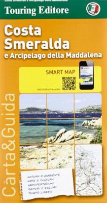
Wegenkaart - landkaart Costa Smeralda en Maddalena | Touring Club Italiano

0
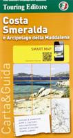
Gedetailleerde toeristische overzichtskaart, gedrukt op scheur- en watervast materiaal. Met stadsplattegrondjes van de belangrijkste plaatsen en veel toeristische informatie op de achterkant (Italiaanstalig). Costa Smeralda and the Maddalena Archipelago Smart Map at 1:175,000 from the Touring Club Italiano, printed on light waterproof and tear-res...

Verkopers met dit product

Verkoper
Bezorging
Prijs
DeZwerver.nl logo
DeZwerver.nl
2,95
10,95

Anderen bekeken ook

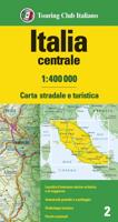
Wegenkaart - landkaart 2 Italië Centraal | Touring Club Italiano
Central Italy at 1:400,000 from the Touring Club Italiano, printed on light, waterproof and tear-resistant plastic paper; one of the titles in a series of three touring maps conveniently grouping together several popular holiday areas. The maps very effectively present the country’s topography with attractive altitude colouring, supplemented by names of numerous hill and mountain ranges, valleys, etc, plus spot heights for selected peaks. National parks and scenic routes are highlighted. National parks and scenic routes are highlighted. Grading according to the degree of importance and interest is given not only to towns, villages and historical or architectural sites, but also to holiday resorts and natural curiosities. Symbols highlight churches, monasteries, castles, palaces, ruins and archaeological sites, caves and waterfalls, etc. The maps also provide some information on accommodation, indicating selected isolated hotels, refuges, tourist villages and campsites, Road network st…
13,95
Stadsplattegrond Centrocittà Pocket Venetië | Touring Club Italiano
Venice street pocket map with Touring Club Italiano’s excellent, clear cartography; indexed, with a diagram of the vaporetto network, information about main sights, useful addresses, etc. The plan, printed on light, waterproof and tear resistant plastic paper, has clear, elegant cartography. Coverage does not include the area east of the Arsenale (i.e. no Biennale grounds), Giudecca or the islands of the Lagoon beyond the San Michele cemetery. The city’s numerous palaces, churches and other places of interest are clearly named. Vaporetto piers are marked and named, but the lines themselves are shown only on a separate diagram of the whole network accompanied by a list of lines and terminals. Street index is on the reverse includes churches, palaces, canals, museums, etc. The plan is accompanied by a diagram of the vaporetto network, a small map of the city’s environs including Treviso, plus lists of main sights with opening hours, etc., and contact details of other useful institutions…
7,95
Wegenkaart - landkaart Turkey - Turkije | Marco Polo
Duidelijke wegenkaart van Marco Polo: alle wegen, zowel de verharde als belangrijke onverharde wegen zijn weergegeven.  Mooie toeristisch interessante wegen die de moeite waard zijn, zijn groen gearceerd. Veel toeristische informatie is toegevoegd zoals de nationale parken, campings, kastelen en vliegvelden. Afstanden tussen belangrijke steden en benzinestations staan ook op de kaart. Een plaatsnamenregister ontbreekt niet.   Let the Marco Polo Türkiye / Turkey Road Map guide you around this stunning country.   From the Turquoise Riviera to the Fairy Chimneys of Cappadocia this highly durable, detailed touring map of Turkey will ensure you don’t miss a thing. It folds away easily and is always on standby to help when you're stuck.   Perfect touring map - the scale is 1 : 800 000 ideal to help you tour the country by car or campervan Easy to use - the superbly clear mapping in strong colours and easy to read text will help you navigate the country like a local Durable, tear-resi…
14,95
Wegenkaart - landkaart Ierland - Ireland | Marco Polo
Duidelijke wegenkaart van Marco Polo: alle wegen, zowel de verharde als belangrijke onverharde wegen zijn weergegeven.  Mooie toeristisch interessante wegen die de moeite waard zijn, zijn groen gearceerd. Veel toeristische informatie is toegevoegd zoals de nationale parken, campings, kastelen en vliegvelden. Afstanden tussen belangrijke steden en benzinestations staan ook op de kaart.  Discover picturesque towns and dramatic coastlines with this highly durable, detailed touring map of Ireland. It folds away easily and is always on standby to help when you're stuck.   Perfect touring map - the scale is 1 : 350 000 ideal to help you tour the country by car or campervan Easy to use - the superbly clear mapping in strong colours and easy to read text will help you navigate the country like a local Durable, tear-resistant map - designed to withstand the rigors of the road, the map is printed on tear-resistant, water repellent and writeable paper Highlights included - major sights and key p…
14,95
Wegenkaart - landkaart Corsica - Korsika | Freytag & Berndt
Deze bijzonder gedetailleerde Freytag & Berndt Wegenkaart van Corsica is aan één kant geprint en heeft een schaal van 1:150.000. Op deze kaart staan o.a. fietsroutes, lange afstandswandelpaden, toeristische wegen en bezienwaardigheden aangegeven. In de omslag van de kaart is een apart boekje geniet met een korte beschrijving van de TOP 10 van bezienswaardigheden, een uitgebreide index en plattegrondjes van enkele toeristische plaatsen. Explore the Mediterranean island of Corsica with this Freytag & Berndt single-sided road and leisure map. The best way to plan your trip, prepare your itinerary, and to travel independently on this region. As with all Freytag & Berndt maps, the cartography is clear and detailed with the topography shown with relief shading with plenty of spot heights.   This map features a full map of the island. Using Freytag & Berndt's icon system, important tourist information is shown. You will see icons for tourist information such as:   Picturesque towns and panor…
14,95
Wegenkaart - landkaart Switzerland - Zwitserland | Marco Polo
Marco Polo Switzerland Map: the ideal map for your trip   Let the Marco Polo Switzerland Road Map guide you around the Switzerland. Discover quaint mountain villages, shimmering lakes, high peaks, stunning waterfalls and exquisite cities with this highly durable, detailed, touring map of Switzerland. It folds away easily and is always on standby to help when you're stuck. Perfect touring map - the scale is 1 : 275 000 ideal to help you tour the region by car or RV Easy to use - the superbly clear mapping in strong colors and easy to read text will help you navigate the country like a local   Durable, tear-resistant map - designed to withstand the rigors of the road, the map is printed on tear-resistant, water repellent and writeable paper Highlights included - major sights and key points of interest are marked on the map by numbered stars. Further information about these key sights can be downloaded via a QR code where you’ll find a brief description to help you pick the best places t…
14,95
Wegenkaart - landkaart Kanada - Canada | Marco Polo
Marco Polo Canada Map: the ideal map for your trip   Let the Marco Polo Canada Map guide you around this incredible country. Plan your great Canadian road trip with this highly durable, overview map of Canada. It folds away easily and is always on standby to help when you're stuck.   Perfect touring map - the scale is 1 : 4 000 000* ideal to help you tour the main highways by car, RV or campervan Easy to use - the super clear mapping in strong colours and clear text will help you navigate easily Includes 6 city maps - detailed street maps of Calgary, Montreal, Ottawa, Quebec, Toronto, Vancouver as well as maps of key National Parks including Jasper, Banff, Yoho, Kootenay and Waterton Lakes Canada highlights - major sights and key points of interest are marked on the map by numbered stars and these are listed in the index booklet with a brief description to help you pick the best places to see en route Extensive index - the thorough index is fully cross-referenced to the map to help yo…
14,95
Fietskaart 02 Cycling guides Cotswolds cycling | Goldeneye
Fietskaart van Cotswold met ondermeer 28 ingetekende rondritten en veel toeristische informatie. Explore the Cotswolds by bike with this laminated, waterproof Cotswolds map. With 28 circular, clearly-marked routes this easy-to-use map will help you discover the best of the Cotswolds along the quietest country lanes. The Cotswolds are ideal for the touring cyclist and day-tripper.   They represent England at her very best. Long, winding lanes connect beautiful villages with excellent pubs and friendly tearooms. The landscape you cycle through is rich in imagery; rolling hills, dry-stone walls, lazy trickling trout streams and quaint, undisturbed hamlets.   Our Cotswold Cycling Country Lanes map includes:* Traffic-free family cycling trails - including the Stroud Valley Cycle Trail, The Oxford Waterway and the Forest of Dean Family Trail with recommendations on where to park. * National Cycle Network routes - the linked series of traffic-free paths and traffic-calmed roads being de…
15,95
Wegenkaart - landkaart Iconic Map Fraser Island - Australië | Hema Maps
Detailkaart van een deel van Australië. Zeer goed leesbaar, met naast de topografische details veel symbolen waarmee allerhande toeristische zaken worden aangeduid als campsites, nationale parken, attracties, wandelmogelijkheden etc. This map is the only complete map of Fraser Island that gives full topographic contours. In addition, all the tracks on the island have been graded accurately and located using Hema's GPS mapping system. The reverse side includes large colour photos, comprehensive text on the history, environment and attractions, and a telephone directory for accommodation, permits, tours and more. Detailed map of the island with contours at 20m intervals plus colouring and graphics to indicate various types of terrain and protected areas, including national and marine parks. Four scenic drives are highlighted and given brief descriptions. The map also shows vehicle entry restrictions, tracks, and footpaths, including the Fraser Island Great Walk. A wide range of symbols …
17,50
Wegenkaart - landkaart Liechtenstein & Oostenrijk West | ITMB
Europe is dotted with mini-states that exist solely for historic reasons but are fiercely independent. Liechtenstein, surrounded by Switzerland on its west and south and Austria on its other borders, is such a state. It is larger and more diverse than many imagine and is quite a popular ski resort region. Side 1 is a detailed map of the principality, framed on the west by the Rhine River and a bit of Switzerland and on the east by Austria. Most development occurs in the Rhine Valley in a north-south direction, dominated by the capital city of Vaduz. There are five access points from Switzerland across the Rhine, one from the south, and two from Austria in the north. The ski haven of Malbun is prominently shown, and the scale of the map is detailed enough to name every major street. This also enabled us the opportunity to include schools, shopping areas, post offices, and churches, as well as a wide range of eating establishments. Walking/hiking trails have also been included. This is …
14,95

Klanten-reviews van Wegenkaart - landkaart Costa Smeralda en Maddalena | Touring Club Italiano

Er zijn nog geen beoordelingen voor dit productBen jij de eerste die een review plaatst?

Meer over Wegenkaart - landkaart Costa Smeralda en Maddalena | Touring Club Italiano

Productomschrijving

Gedetailleerde toeristische overzichtskaart, gedrukt op scheur- en watervast materiaal. Met stadsplattegrondjes van de belangrijkste plaatsen en veel toeristische informatie op de achterkant (Italiaanstalig).

Costa Smeralda and the Maddalena Archipelago Smart Map at 1:175,000 from the Touring Club Italiano, printed on light waterproof and tear-resistant synthetic paper, with a street plan of central Olbia annotated with main sights, plus 11 more recommendations of places worth visiting. Coverage extends from the Straights of Bonifacio between Sardinia and Corsica southwards to Ozieri and Pattada.   Cartography is an enlargement of TCI’s excellent regional series at 1:200,000. Additional overprint highlights the publishers’ recommendations. On the reverse are notes, based on Touring Editore’s vast experience of presenting the country’s heritage and culture, about various aspects of the region: nature, art, local festivals, etc, or, since all the text is in Italian only: natura e ambiente, arte e cultura, manifestazioni, sapori e colori and tempo libero.   Map legend and all the text are in Italian only.

Verken gerelateerde categorieën

Webshop.nl maakt gebruik van cookies. Ga je verder op onze website, ga dan akkoord met het plaatsen van cookies en de verwerking van deze data door ons en vermelde partners.