webshop.nl
Categorieën
  Sluiten

Meer Goldeneye
Meer Goldeneye in Literatuur boeken

Wegenkaart - landkaart Cornwall | Goldeneye

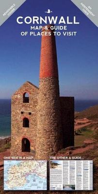
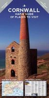
Cornwall Map and Guide of Places to Visit is the ideal guide to the very best of Cornwall. Cornwall remains Britain's Number 1 holiday destination for a week or a fortnight's break. Our Goldeneye Cornwall Leisure Map & Travel Guide has been researched, compiled and published in Cornwall by Cornish locals.   Our team knows Cornwall like no other org...
16,50

Webshops met dit product

Webshop
Bezorging
Prijs

Anderen bekeken ook

Wegenkaart - landkaart Cornwall | Goldeneye
Cornwall Map and Guide of Places to Visit is the ideal guide to the very best of Cornwall. Cornwall remains Britain's Number 1 holiday destination for a week or a fortnight's break. Our Goldeneye Cornwall Leisure Map & Travel Guide has been researched, compiled and published in Cornwall by Cornish locals.   Our team knows Cornwall like no other organisation! Our Cornwall Map & Guide presents Cornwall's multiple attractions in an accessible, easy-to-read and follow, format. In fact, we've been producing this publication for over 30 years and it is firmly part of our DNA. The Cornwall Map and Guide is in the format of a fold-out map and has a detailed visitor map on one side and visitor information on the other: Cornwall Visitor MapAn unbelievably detailed map on one side with lots of additional visitor informationThe ideal scale for touring at 1:126,720 (2 miles to 1 inch)Tourist attractions like beaches & surfing, gardens, harbours & National Trust properties are clearly highlightedCle…
16,50
Fietskaart 01 Cycling guides Cornwall | Goldeneye
Our maps are double-sided, printed on an A2 sheet with a concertina fold. This allows for easy folding and folding, and an ease of access to the mapping. The material is rain and tear-resistant. Our early maps were designed at the scale of 2 miles to 1 inch/1:126,720. The later designs along with digitalisation are 1: 100,000. We were encouraged by the Cycle Touring Club to convert our cartography toward the cycle market (to replace the out-of-print Bartholomew series). As time and the series progressed we have added more data: The National Cycle Network routes, Regional Routes, and Traffic-Free Family Routes, as and when they are developed. These routes are in addition to the Circular Routes Goldeneye Commissioned at the outset of our publishing schedule. We are also adding to new editions; bike shops, cycle hire, and tea rooms, along with the tourist attractions already featured. Our plan is to make available digital versions for cell phones and tablets and to update, on an annual ba…
15,95
Wegenkaart - landkaart Icefields Parkway | Gem Trek Maps
Whether you have a day or a week to spend exploring the sights along the spectacular Icefields Parkway highway, Gem Trek's ICEFIELDS PAKRWAY MAP, a combination map and guide, will help you make the most of your time. Like our much-loved hiking maps, our Icefields Parkway map features detailed cartography and is printed on waterproof and tear-resistant paper.   The Icefields Parkway Map shows all viewpoints, picnic areas, trailheads, campgrounds, hostels, lodges and other services along the Icefields Parkway, while the descriptions in the guide point you to the best of these - the best viewpoints of mountains and lakes, the most interesting points of interest and exhibits, and the best bets for spotting wildlife such as moose, bighorn sheep and mountain goats.   Also included are short descriptions of the ten best walks and day hikes along the Icefields Parkway—from the short stroll to Peyto Lake Viewpoint to the rewarding hike through alpine meadows to Helen Lake.   To make it easier t…
13,50
Reisgids Cornwall | Time Out
Escape to Cornwall with the Time Out Cornwall guide and uncover the best this wonderful county has to offer. We've used our local knowledge to reveal the best of the county and while we've included all the big attractions, we've gone beneath the surface to uncover plenty of small or hidden treasures too. With miles of magnificent coastline, hidden coves, walks and cycle trails galore, wonderful wildlife, exquisite towns and villages and a vibrant food scene, historic houses and gardens aplenty, Time Out Cornwall will help you uncover the best of this beautiful region.   About the Time Out Cornwall guide:Grouped by region - all the information for each region is grouped together so you can easily plan your day, weekend or short breakDetailed overview map of each region - each region is illustrated with a super-clear map so you can start to plan your routeBeautiful photographs - be inspired by all the amazing sights with these gorgeous photos that bring the region to life before you've e…
19,95
Wegenkaart - landkaart 02 Canadian Rockies Banff & Jasper | Gem Trek M
Goede wegenkaart van Banff & Jasper met bezienswaardigheden, Overnachtingsmogelijkheden, Campings en hete bronnen. This is our most popular driving (touring) map and the map most recommended as an overview for anyone planning a trip to the Canadian Rocky Mountain Parks - Banff, Jasper, Yoho and Kootenay. It also covers Mount Revelstoke and Glacier national parks, the Bugaboos and the Purcell Mountains further west.  29 of the best points of interest in the Rocky Mountain Parks are numbered and described. Mountain lodges, campgrounds, hostels, hot springs, golf courses, ski areas, picnic sites, visitor centres and highway viewpoints are labelled. The mountains are also labelled with their name and elevation, if available, and glaciers are easy to pick out because they are shown in a different colour.  On the back, you will find a map of Western Canada showing all the major highways, as well as maps showing the major arteries in the cities of Edmonton and Calgary. There are also town map…
13,95
Wegenkaart - landkaart Cotswolds map and guide | Goldeneye
Detailkaart op schaal 1:126.000 van de Cotswolds. Veel detail, met veel symbolen worden ook de toeristische hoogtepunten weergegeven.  This was the first publication I produced. A Map-Guide close to my heart, and one that I believe improves with age. It was the acorn that set off my oak tree and remains to this day, my favourite publication. It is the simple combination of the Map and the Guide that makes exploring the Cotswolds such a pleasure.   • Where to Go, What to See, What to Do... and Where to Eat & Drink... • The ideal publication for a short break, a long weekend, or your first-ever visit to the Cotswolds... • Save time and money by choosing this practical combination of a Leisure Map, backed up by a Travel Guide with 5 Scenic Drives (car tours) described and highlighted on the Map   The Leisure Map • The ideal scale for touring @ 1:126,720 (2 miles to 1 inch) • Tourist Attractions/Inns With Rooms/Hotels are illustrated • Altitude Layering indicates the topography …
15,95

Klanten-reviews van Wegenkaart - landkaart Cornwall | Goldeneye

Er zijn nog geen beoordelingen voor dit productBen jij de eerste die een review plaatst?

Meer over Wegenkaart - landkaart Cornwall | Goldeneye

Productomschrijving

Cornwall Map and Guide of Places to Visit is the ideal guide to the very best of Cornwall. Cornwall remains Britain's Number 1 holiday destination for a week or a fortnight's break. Our Goldeneye Cornwall Leisure Map & Travel Guide has been researched, compiled and published in Cornwall by Cornish locals.   Our team knows Cornwall like no other organisation! Our Cornwall Map & Guide presents Cornwall's multiple attractions in an accessible, easy-to-read and follow, format. In fact, we've been producing this publication for over 30 years and it is firmly part of our DNA. The Cornwall Map and Guide is in the format of a fold-out map and has a detailed visitor map on one side and visitor information on the other: Cornwall Visitor MapAn unbelievably detailed map on one side with lots of additional visitor informationThe ideal scale for touring at 1:126,720 (2 miles to 1 inch)Tourist attractions like beaches & surfing, gardens, harbours & National Trust properties are clearly highlightedClear and easy-to-follow cartography, also easy to fold and unfold Cornwall Travel GuideAll the information you need is shown on the reverse side of the map ensuring you will see the very best of CornwallThe best things to see and do are grouped into the following sections: Main Centres; Villages of interest; Little harbours & ports of interest; Foodie Pubs; Cafes, Diners & Tea Rooms; Industrial interest; Mine shafts & engine houses; Gardens; Historic buildings; Museums; Ancient monuments, stone circles & hill forts; Great Cornwall churches; Galleries & workshops; Railway & canal interest; Country parks & places of natural interest; Farm & countryside interests; Birds & wildlife; Theatres; Family fun & adventure; Film & TV locationsA guide to the coastal footpaths including the distance and what to see and expect en routeIllustrated with full-colour photographs, our renowned map and guide to Cornwall will make it easy to plan your trip.   It really is the 'go-to' guide and map for the very best of Cornwall.

Productspecificaties

Artikelnummer(s)
Brand
Goldeneye

Verken gerelateerde categorieën

Webshop.nl maakt gebruik van cookies. Ga je verder op onze website, ga dan akkoord met het plaatsen van cookies en de verwerking van deze data door ons en vermelde partners.