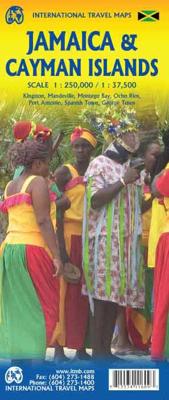
Wegenkaart - landkaart Cayman Islands (Kaaiman Eilanden) & Jamaica | ITMB

0
Een degelijke kaart met aanduidingen van o.a. nationale parken, vliegveld, benzinepomp, dirt-roads en kleine plattegrond van verschillende steden. Als overzichtskaart goed te gebruiken. De kaart is aan twee zijden bedrukt, de ene zijde omvat de Cayman Islands (schaal 1:37.500 en 1:70.000). Op de andere zijde staat de kaart van Jamaica (schaal 1:25...

Verkopers met dit product

Verkoper
Bezorging
Prijs
DeZwerver.nl logo
DeZwerver.nl
2,95
13,95

Anderen bekeken ook

Nieuw
Wegenkaart - landkaart Virgin Islands - Maagden eilanden | Borch
The soft-laminated map of the Virgin Islands includes: US Virgin Islands 1:80 000, St. Croix 1:80 000, Charlotte Amalie 1:15 000, Charlotte Amalie Historic District 1:7 500, Cruz Bay 1:15 000, Christiansted, Frederiksted 1:15 000, British Virgin Islands 1:80 000, Anegada 1:80 000, Road Town, The Valley (Spanish Town) 1:15 000, Lesser Antilles 1:7 000 000, Virgin Islands administrative / time zones; interesting statistics British / US Virgin Islands: conversion chart for temperatures, weights and measures; climate chart with temperatures, sunshine hours, precipitation and humidity; hotels, museums, markets and much more.   Virgin Islands is the name of two groups of small islands east of Puerto Rico which form the Virgin Islands archipelago. They lie between the Caribbean Sea and the Atlantic Ocean. One of the groups which consists of St. Croix, St. John and St. Thomas islands, together with many nearby islets, is called the U.S. Virgin Islands. The other group including Anegada, Jost …
11,50
Reisgids InFocus Cayman Islands - Kaaiman eilanden | Fodor's Travel
Whether you want to hit the surf on Seven Mile Beach, go snorkeling in turquoise waters, or dine on fresh seafood at waterfront restaurants, the local Fodor's travel experts in the Cayman Islands are here to help! Fodor's InFocus Cayman Islands guidebook is packed with maps, carefully curated recommendations, and everything else you need to simplify your trip-planning process and make the most of your time. This new edition has been fully-redesigned with an easy-to-read layout, fresh information, and beautiful color photos. Fodor's InFocus Cayman Islands travel guide includes: AN ILLUSTRATED ULTIMATE EXPERIENCES GUIDE to the top things to see and do MULTIPLE ITINERARIES to effectively organize your days and maximize your time MORE THAN 10 DETAILED MAPS to help you navigate confidently COLOR PHOTOS throughout to spark your wanderlust! HONEST RECOMMENDATIONS FROM LOCALS on the best sights, restaurants, hotels, beaches, scuba diving sites, outdoor activities, nightlife, shopping, an…
15,50
Nieuw
Wegenkaart - landkaart USA Pacific Coast Travel Reference Map | ITMB
Coverage is from Vancouver to Tijuana to Las Vegas, and information includes rest areas, parks, touristic attractions and the like, as well as detailed road information. There are no inset maps on this title, which also makes a very nice wall map of the west coast!   Legend Includes: International Boundary, State Boundary, County Boundary, Interstate Hwy, Freeway / UC, Toll Hwy / UC, Multilane Hwy / UC, US Divided Hwy, Two lane road / State Highway, Other Road / Track, Pacific Crest Trail, Ferry Route, Time Zone, Mountain peak (feet) State Park, National Forest, National Park, Exit Number and approx. distance between two exists (dist. in miles), Approx. Road Distance (in miles), Interstate Highway, United States Highway, State Highway, Historic Route 66, Large Urban area, State Capital, More than 250,000, 85,000 - 250,000, < 85,000, Town, River / Lake, Salt Lake, Indian reserve, Military property area, Rest Area, Lodge, Point of Interest, Natural Point of Interest, International Airpo…
13,95
Wegenkaart - landkaart SC3-SC4 Swellendam to Mossel Bay | Tracks4Africa
The Cape to Addo map series covers the southern parts of the Western Cape of South Africa in a series of eight highly detailed maps, printed on four sheets of A1 durable paper.   We start in Cape Town in the west and move along the southern coast through the Overberg, Winelands, Garden Route, Klein Karoo R62, Baviaanskloof to eventually arrive in the Addo National Park up to Gqeberha (Port Elizabeth) in the east.   The maps are highly detailed and well researched. Our map scale is 1:200 000 which allows us to show a lot of detail including minor gravel roads, hiking trails, farm boundaries and points of interest which are relevant to self-drive tourists.   The size of the paper is kept small enough to allow this to be the perfect road tripping map. We use Duraflex paper and print two maps per sheet of A1 paper, making this a four-sheet series. Each map sheet is individually packed in a plastic protective sleeve.   The maps are perfect for day drives, overlanding or just doing road tri…
29,95
Waterkaart Caribbean Cruising | ITMB
The Caribbean Sea is one of the most popular cruising destinations in the world. This colourful double-sided map starts just north of Orlando/Tampa in order to show the northernmost Bahamian islands and south as far as the Panama Canal at Colon and the coast of Venezuela. The map shows good detail for each island and the legal boundaries of each island nation. Side 1 concentrates on the western Caribbean, essentially the Bahamas, Cuba, Jamaica, and the Cayman Islands. Here’s a fun fact most of you won’t know: tiny Navassa Island between Haiti and Jamaica is claimed by both the USA and Haiti! Side 2 concentrates on the eastern islands of the Caribbean, such as Hispaniola (Haiti and the Dominican Republic), Puerto Rico and the US and British Virgin Islands, Turks & Caicos, and the Lesser Antilles chain of island countries, such as Antigua, Guadeloupe, Barbados, and Trinidad/Tobago, among others. Coverage then extends westward along the Venezuelan coastline to include the Dutch possessio…
14,95
Nieuw
Wegenatlas Travel Atlas Caribbean Island West Half | ITMB
  Wegenatlas voor de westelijke Caraïbische eilanden - verschillende schalen : Bahamas, Turks- en Caicoseilanden, Cuba, Kaaimaneilanden, Jamaica, Dominikaanse Republiek, Puerto Rico. Met inzetjes van Freeport, Nassau, Havana, Varadero, Georgetown, Kingston, Port-au-Prince, Santo Domingo, San Juan   The Caribbean is a particularly difficult part of the world to map effectively. It is a combination of larger islands in the west and a string of small islands in the east. Some can be shown as separate maps, but others are too small (or too lacking in market appeal) to be mapped adequately as folded paper maps. This atlas covers the Bahamas and the Turks and Caicos Islands in the north with Cuba, the Cayman Islands, Jamaica, the Dominican Republic, and Puerto Rico in scales ranging from 1:18,000 for Puerto Rico to 1:600,000 for Cuba The atlas is the same size as all ITM atlases (8''x5'' or 21x13.5cm) and has a straight spine edge with title for displaying spine outwards on store shelves, i…
16,50
Nieuw
Wegenkaart - landkaart US Virgin Islands & Puerto Rico | ITMB
Puerto Rico: schaal 1:190.000 US Virgin Islands: schaal 1:50.000   We are really pleased with this new edition of Puerto Rico. We spent part of August, 2020, touring the island and geo-referencing its many highways. The island is bigger and more densely road-networked than we thought, so we'll have to complete the job on our next visit, but the roads are now much more precisely shown accurately than was possible before satellite imagery. The map looks great on an Ipad screen as well. The map also shows updated inset maps of San Juan, Ponce, Mayaguez, Aguadilla, and Arecibo. Puerto Rico is part of the United States, so has all the benefits, but is internally self-governing. With this edition we are including a map of the other US colonial territory, the US Virgin Islands. The Danish West Indies was purchased from Denmark in 1917 and is an integral part of the USA, with all its benefits, but is, like Puerto Rico, neither fish nor fowl. It is internally self-governing and a great retirem…
13,95
Nieuw
Wegenkaart - landkaart Tasmania & Victoria | ITMB
Een degelijke wegenkaart van Tasmanie & Victoria, schaal 1:1.800.000, en Tasmanië, schaal 1:800.000 met aanduidingen van o.a. nationale parken, vliegveld, benzinepomp, dirt-roads. Als overzichtskaart goed te gebruiken. The island of Tasmania is Australia’s smallest state, but is packed with touristic delights. Hobart is the capital and a charming Victorian city in the south of the island. Much of the west coast is a large nature preserve with limited access and most development is close to the northern shore, centred on Devonport and its ferry connections with Melbourne, in Victoria State. Tasmania also administers several offshore islands, such as King, Flinders, and Bruny. We have included a Top Attractions listing for the reader to enjoy. The other side of the sheet is the Australian mainland state of Victoria, best known as the home of Melbourne and the beautiful coastal highway to Adelaide. A basic inset map of Melbourne is included, but the focus of the map is on the recreationa…
13,95
Wegenkaart - landkaart Tahiti - French Polynesia | ITMB
Anyone who has visited Tahiti retains fond memories of a wonderful Polynesian paradise. This map shows the major islands of French Polynesia as a series of large insets on Side 1. An overall inset map showing the many islands is also shown, but for showing detail, one must expand the individual islands. The largest one is the volcanic Tahiti Nui, with the capital city of Pape’ete (or Papeete in English), for which a detailed inset map is included. Most visitors stay in the vicinity of Papeete, along the coast. We show several popular resorts. There is a good circular road around the island’s shoreline, but no roads in the interior. The island is joined to another, called Tahiti Iti, or Little Tahiti, and roads extend partway around this less-developed part of the combined island. Most of the other islands are rarely visited, although they have resorts, beaches, and a lifestyle of their own. Names like Huahine, Riatea, Tahaa, and Maiao may not be as familiar as they should be, but all …
14,95
Nieuw
Wegenkaart - landkaart Spitsbergen Svalbard | ITMB
North of Norway exists one of the northernmost communities in the world, an archipelago of islands called Svalbard in Norwegian, and better known as Spitsbergen in English. Until now, it has only been available in map format from the Norwegian Arctic Institute, and then only with difficulty. Side one shows the various islands as an entity. There is only one town of any size in the islands, called Longyearbyen, although there is a more northerly town called Pyramiden and an isolated community on the west coast called Alesund. This is true high Arctic adventure travel; one does not come here unprepared! Most of the islands are uninhabited and largely ice-covered. Edge Island, for example, is a large nature reserve, and Prins Karl Forland is a national park. We have translated land area names into English and placed the Norwegian names in brackets, but have tried leaving the Norwegian names in place wherever possible to assist with local usage. This is one of those ‘off the beaten path’ …
13,95

Klanten-reviews van Wegenkaart - landkaart Cayman Islands (Kaaiman Eilanden) & Jamaica | ITMB

Er zijn nog geen beoordelingen voor dit productBen jij de eerste die een review plaatst?

Meer over Wegenkaart - landkaart Cayman Islands (Kaaiman Eilanden) & Jamaica | ITMB

Productomschrijving

Een degelijke kaart met aanduidingen van o.a. nationale parken, vliegveld, benzinepomp, dirt-roads en kleine plattegrond van verschillende steden. Als overzichtskaart goed te gebruiken. De kaart is aan twee zijden bedrukt, de ene zijde omvat de Cayman Islands (schaal 1:37.500 en 1:70.000). Op de andere zijde staat de kaart van Jamaica (schaal 1:250.000) en plattegronden van onder andere Kingston.

We are pleased to announce the latest new Caribbean map to our growing series. The Caymans, for there are three major islands and numerous little shoals, remains a British colony, like the British Virgin Islands, the Turks and Caicos, and Bermuda. Tourism is the number one industry of the Cayman Islands, with dozens of hotels dotting the beachfronts, especially north of George Town. There are numerous dive sites for viewing tropical fish and we have shown about a hundred on the map, as well as every side street and gas station. One interesting place to visit is Hell, which is a frozen lava eruption at the north end of Grand Island that looks like, well, hell. The reverse side of the map includes a map of Jamaica and Kingston. This is included for marketing purposes only, for those planning on visiting both islands.    Legend Includes: Roads by classification, County Boundary, Parish Boundary, Highway, Main Road, Secondary and other Road, Track, Railway, National Highway Number, Capital, City, Parish Capital Town, Town and Small Town, Village, River and Seasonal River, Swamp, Park, International Airport, Landing Ground, Bus Station, Gas Station, Lighthouse, Harbour, Fort, Hotel, Restaurant, Museum, Monument, University and College, Point of Interest, Beach, Tourist Information Centre, Cove, Golf Course, Pass, Surfing, National Park, Waterfall, Sugar Estate, Viewpoint, Mountain Peak, Marina and Sea-Port, Diving, Hiking Trail, Hospital and much more

Verken gerelateerde categorieën

Webshop.nl maakt gebruik van cookies. Ga je verder op onze website, ga dan akkoord met het plaatsen van cookies en de verwerking van deze data door ons en vermelde partners.