Wegenkaart - landkaart Californië - California | Borch

0
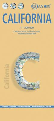
Mooie geplasticieerde kaart van Californië. Deze kaart biedt een goed overzicht van dit deel van de Verenigde Staten met detailkaarten.   Our soft-laminated folded map of California shows: California North 1:1 200 000, California South 1:1 200 000, Yosemite National Park 1:675 000, USA administrative and time zones. Borch Maps are easy to fold, du...

Verkopers met dit product

Verkoper
Bezorging
Prijs
DeZwerver.nl logo
DeZwerver.nl
2,95
11,50

Anderen bekeken ook

Stadsplattegrond San Francisco | Borch
Borch San Francisco is een duidelijke, geplastificeerde plattegrond van het centrum met informatie over openbaar vervoer en bezienswaardigheden. Inclusief straatnamenregister.   Our soft-laminated folded map of San Francisco shows: San Francisco Downtown 1:13 000, Alcatraz Island 1: 15 000, Golden Gate Park 1:13 000, San Francisco and Region 1:150 000, San Francisco Bay Area 1:400 000, Public Transport San Francisco, Top 30 Sights and USA administrative and time zones. Borch maps are easy to fold, durable and water-repellent with a wipeable surface. Borch Maps show hotels, museums, monuments, markets, top sights and points of interest, useful statistics, conversion charts for temperatures, weights and measurements, climate charts showing temperatures, sunshine hours, precipitation and humidity, overview maps, time zones, and much more...   The 14th most populous city in the U.S. and the 4th most populous in California is best known for its Golden Gate bridge, cable cars, steep hills l…
9,95
Nieuw
Wegenkaart - landkaart Belize | Borch
Mooie, geplastificeerde kaart van Belize. Deze kaart biedt een goed overzicht van het land met detailkaarten.   Our soft-laminated folded map of Belize in the 5th edition shows: Belize 1:500 000, Belize City 1:13 000, San Ignacio & Santa Elena 1:25 000, Yucatan Peninsula 1: 2 750 000, Ambergris Caye & Caye Caulker 1:250 000, the Maya sites Altun Ha 1:3 000, Cahal Pech 1:2 500, Caracol 1:7 000, Cerros 1:4 000, El Pilar 1:8 000, Lamanai 1:9 000, Lubaantun 1:5 000, Nim Li Punit 1: 7 000, Xunantunich 1:7 000 and Belize administrative. Borch Maps are easy to fold, durable and water-repellent with a wipeable surface. Borch Maps show hotels, museums, monuments, markets, public transport, top sights and points of interest, useful statistics, conversion charts for temperatures, weights and measurements, climate charts showing temperatures, sunshine hours, precipitation and humidity, overview maps, and much more...   Known as British Honduras until about 1973, Belize is today no longer a Bri…
11,50
Nieuw
Wegenkaart - landkaart Aruba | Borch
Mooie, geplastificeerde kaart van Aruba. Deze kaart biedt een goed overzicht van het land met detailkaarten.   Our soft-laminated folded map of Aruba shows: Aruba 1:50 000, Beaches 1:25 000, Oranjestad 1:10 000, San Nicolas 1:20 000, ABC Islands 1:1 000 000, Lesser Antilles 1:7 000 000, Lesser Antilles time zones. Borch maps are easy to fold, durable and water-repellent with a wipeable surface. Borch Maps show hotels, museums, monuments, markets, public transport, top sights and points of interest, useful statistics, conversion charts for temperatures, weights and measurements, climate charts showing temperatures, sunshine hours, precipitation and sea temperatures, overview maps, time zones, and much more...   Aruba is the westernmost of the "ABC" islands (Aruba, Bonaire, Curaçao) and approximately 30 km off the coast of Venezuela. Sun-aficionados know these islands are home to probably the most beautiful sand beaches of the Caribbean. Wind and water conditions are ideal for the inte…
11,50
Nieuw
Wegenkaart - landkaart Costa Rica | Borch
Mooie geplasticieerde kaart van Costa Rica. Deze kaart biedt een goed overzicht van het land met detailkaarten.   Our soft-laminated folded map of Costa Rica shows: Costa Rica 1:650 000, Cocos Island 1:150 000, San Jose 1:20 000, Meseta Central 1:300 000, Costa Rica administrative and time zones. Borch maps are easy to fold, durable and water-repellent with a wipeable surface. Borch Maps show hotels, museums, monuments, markets, public transport, top sights and points of interest, useful statistics, conversion charts for temperatures, weights and measurements, climate charts showing temperatures, sunshine hours, precipitation and humidity, overview maps, time zones, and much more...   The Republic of Costa Rica ("rich coast") is bordered by Nicaragua, Panama, the Pacific Ocean and the Caribbean Sea. Costa Rica abolished its army in 1949 and is an oasis of peace and tranquility in Central America. Democracy, a policy of neutrality and exemplary environmental standards (approx. 25% of t…
11,50
Nieuw
Wegenkaart - landkaart Toscane | Borch
Mooie geplasticieerde kaart van Toscane. Deze kaart biedt een goed overzicht van dit deel van Italië met detailkaarten.   Our soft-laminated folded map of Tuscany in the 8th edition shows: Tuscany 1:400 000, Florence 1:9000, Siena 1:8 000, Pisa 1:7 000, Lucca 1: 12 000, Italy administrative and time zones. Borch Maps are easy to fold, durable and water-repellent with a wipeable surface. Borch Maps show hotels, museums, monuments, markets, public transport, top sights and points of interest, useful statistics, conversion charts for temperatures, weights and measurements, climate charts showing temperatures, sunshine hours, precipitation and humidity, overview maps, time zones, and much more...   In the midday sun the cypress trees, vineyards and olive groves appear as though behind a thin veil. The picture clears only when the sun has passed its zenith, and if there were no cars on these roads you would believe yourself to be in the middle of a Renaissance painting. Indeed, Michelangel…
11,50
Nieuw
Wegenkaart - landkaart Buenos Aires | Borch
Borch Buenos Aires is een duidelijke, geplastificeerde plattegrond van het centrum met informatie over openbaar vervoer en bezienswaardigheden. Inclusief straatnamenregister.   Our soft-laminated folded map of Buenos Aires in the 7th edition shows: Buenos Aires Centre 1:15 000, Isla Martín Garcia 1:18 000, Núnez 1:15 000, Boca 1:15 000, Buenos Aires 1:75 000, Greater Buenos Aires 1:530 000, Argentina Central 1:3 000 000, Public Transport Buenos Aires, Argentina administrative and time zones, Top 30 Sights. Borch Maps are easy to fold, durable and water-repellent with a wipeable surface. Borch Maps show hotels, museums, monuments, markets, public transport, top sights and points of interest, useful statistics, conversion charts for temperatures, weights and measurements, climate charts showing temperatures, sunshine hours, precipitation and humidity, overview maps, time zones, and much more...   Buenos Aires, located on the Rio de la Plata inlet on the southeastern side of the South Am…
9,95
Nieuw
Wegenkaart - landkaart Peru | Borch
Mooie geplasticieerde kaart van Peru. Deze kaart biedt een goed overzicht van het land met detailkaarten.   Our soft-laminated folded map of Peru shows: Peru North 1:1 750 000, Peru South 1:1 750 000, Amazonian Peru 1:2 500 000, Central Lima 1:18 000, Greater Lima 1:150 000, Central Cuzco 1:12 000, Greater Cuzco 1:50 000, Ayacucho 1:20 000, Arequipa 1:17 000, Chan Chan 1:40 000, Trujillo 1:20 000, Sacsayhuaman 1:10 000, Machu Picchu 1:44 000, Peru administrative & time zones. Borch Maps are easy to fold, durable and water-repellent with a wipeable surface. Borch Maps show hotels, museums, monuments, markets, public transport, top sights and points of interest, useful statistics, conversion charts for temperatures, weights and measurements, climate charts showing temperatures, sunshine hours, precipitation and humidity, overview maps, time zones, and much more...   Bordering Brazil, Bolivia, Chile, Colombia, Ecuador and the Pacific Ocean, the Republic of Peru is the cradle of the Inca …
11,50
Nieuw
Wegenkaart - landkaart Kreta - Crete | Borch
Mooie geplasticieerde kaart van Kreta. Deze kaart biedt een goed overzicht van dit eiland met detailkaarten.   Our soft-laminated folded map of Crete shows: Crete (West) 1:200 000, Crete (East) 1:200 000, Iraklio 1:7 000, Agios Nikolaos 1:6 000, Chania 1:10 000, Ierapetra 1:10 000, Rethimno 1:9 000, Samaria Gorge 1:90 000, Sitia 1:7 000 and Gavdos 1:200 000. Borch maps are easy to fold, durable and water-repellent with a wipeable surface. Borch Maps show hotels, museums, monuments, markets, top sights and points of interest, useful statistics, conversion charts for temperatures, weights and measurements, climate charts showing temperatures, sunshine hours, precipitation and humidity, overview maps, time zones, and much more...   Crete is more than just another Greek island, it is the fifth largest island in the Mediterranean Sea and the cradle of ancient Mediterranean civilization. By 2000 B.C. the Minoans had set up a base here for their international trade with the East, North Afric…
11,50
Nieuw
Wegenkaart - landkaart Argentinië - Argentina | Borch
Mooie, geplastificeerde kaart van het Argentinië. Deze kaart biedt een goed overzicht van het land met detailkaarten.   Our soft-laminated folded map of Argentina shows: Argentina 1:3 800 000, Isla Grande de Tierra del Fuego 1:1 900 000, Los Glaciares National Park 1:750 000, Mount Fitz Roy 1: 250 000, Greater Buenos Aires 1:650 000, Buenos Aires 1:18 000, Cordoba 1:14 000, Salta 1:16 000, Argentina administrative and time zones. Borch Maps are easy to fold, durable and water-repellent with a wipeable surface. Borch Maps show hotels, museums, monuments, markets, public transport, top sights and points of interest, useful statistics, conversion charts for temperatures, weights and measurements, climate charts showing temperatures, sunshine hours, precipitation and humidity, overview maps, time zones, and much more...   Enchanted by the sophisticated European flair of Buenos Aires, watching the world go by from a sidewalk café whilst taking a break from the buzzing nightlife, one could …
11,50
Wegenkaart - landkaart 2 Southwest-USA - Zuidwest USA | Borch
Mooie geplasticieerde kaart van het Zuidwesten van de USA. Deze kaart biedt een goed overzicht van het land met detailkaarten.   Our soft-laminated folded map of the American Southwest shows: American Southwest 1:3 000 000, Phoenix 1:20 000, San Francisco Bay Area 1:400 000, San Francisco 1:15 000, Greater Los Angeles 1:250 000, San Diego 1:125 000, San Diego Downtown 1:25 000, Las Vegas - The Strip 1:22 000, Grand Canyon National Park 1:250 000, USA administrative & time zones. Borch Maps show hotels, museums, monuments, markets, public transport, top sights and points of interest, useful statistics, conversion charts for temperatures, weights and measurements, climate charts showing temperatures, sunshine hours, precipitation and humidity, overview maps, time zones, and much more...   From the panoramas of San Francisco and the buzz of megametropolis Los Angeles to the charm of San Diego on the Mexican border - the Californian coast boasts sun, beautiful beaches, stunning scenery an…
11,50

Klanten-reviews van Wegenkaart - landkaart Californië - California | Borch

Er zijn nog geen beoordelingen voor dit productBen jij de eerste die een review plaatst?

Meer over Wegenkaart - landkaart Californië - California | Borch

Productomschrijving

Mooie geplasticieerde kaart van Californië. Deze kaart biedt een goed overzicht van dit deel van de Verenigde Staten met detailkaarten.   Our soft-laminated folded map of California shows: California North 1:1 200 000, California South 1:1 200 000, Yosemite National Park 1:675 000, USA administrative and time zones. Borch Maps are easy to fold, durable and water-repellent with a wipeable surface. Borch Maps show hotels, museums, monuments, markets, public transport, top sights and points of interest, useful statistics, conversion charts for temperatures, weights and measurements, climate charts showing temperatures, sunshine hours, precipitation and humidity, overview maps, time zones, and much more...   Mountains, ocean, forest, desert - California has everything to offer the visitor. And in Los Angeles, anything is possible: lying on Venice Beach in the morning, skiing in the nearby San Gabriel Mountains in the afternoon, a visit to Disneyland, an exciting tour through Universal Studios, a glimpse of the homes of the rich and famous in Beverly Hills, reminiscing the golden days of Hollywood on the Walk of Fame. But there is still so much more to see and experience, such as San Francisco, Palm Springs, and San Diego with its 112 km of beachfront almost within arm's reach of the Mexican border. Death Valley is the greatest natural attraction and the hottest area in the U.S., boasting spectacular canyons and rock formations. Those who prefer a more moderate climate will enjoy the laid back atmosphere of California's beautiful coastal towns, such as Monterey and Santa Barbara.  

Verken gerelateerde categorieën

Webshop.nl maakt gebruik van cookies. Ga je verder op onze website, ga dan akkoord met het plaatsen van cookies en de verwerking van deze data door ons en vermelde partners.