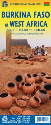
Wegenkaart - landkaart Burkina Faso & West Africa | ITMB

0
Een degelijke kaart met aanduidingen van o.a. nationale parken, vliegveld, benzinepomp, dirt-roads en kleine plattegrond van hoofdstad. Als overzichtskaart goed te gebruiken.   Burkina Faso, formerly the French territory of Haute Volta, is one of those quiet countries of Africa that never seem to hit the headlines. It is typical of several of the ...

Verkopers met dit product

Verkoper
Bezorging
Prijs
DeZwerver.nl logo
DeZwerver.nl
2,95
13,95

Anderen bekeken ook

Wegenkaart - landkaart Afrika noordwest - Africa northwest | ITMB
Een degelijke kaart met aanduidingen van o.a. nationale parken, vliegveld, benzinepomp, dirt-roads en kleine plattegrond van hoofdstad. Als overzichtskaart goed te gebruiken. This is the detailed map of Africa emanating from our continental data base and, at an scale better than Michelin's famous regional map, we feel that this version is a winner. First, it is printed double-sided with the western coastal segment on one side and the eastern half on the other. Second, we have been able to improve the accuracy of the road information enormously at the better scale, and third we are making progress in developing a new series of travel maps for Africa by publishing the first of what we hope will become a new regional map covering Africa from top to bottom, or from Cape to Cairo, as Uncle Cecil used to say. The coverage of this map is from Morocco in the west to the Libyan/Egyptian border and from Senegal and Liberia in the southwest to the Chad/Sudan border in the southeast. This is also…
13,95
Wegenkaart - landkaart Africa east & central - Afrika oost en centraal | ITMB
This is the latest map from our growing digital data base on Africa. One side of this map concentrates on the five countries of what is generally known as East Africa - Kenya, Uganda, Tanzania, Rwanda, Burundi, with bits of neighboring countries thrown in. The second side covers what has always been called Central Africa, probably because it was once British Central Africa. This is Zambia,Zimbabwe, and Malawi, with the northern half of Mozambique and the Okavango delta included, as well as a bit of DEM Congo. The map covers a vast portion of the African continent and includes a diverse ethnic and geographic reality. We have tried to categorize roads by condition, but the reality of Africa is that some main roads are in pretty poor condition. Some secondary roads are not shown as being as good as they probably are, but verifying data for Africa is difficult. This is our first map of this part of the world based on GIS Data. As such, it is much more precisely accurate than anything done…
13,95
Wegenkaart - landkaart Africa North - Noord Afrika | ITMB
Een degelijke wegenkaart met aanduidingen van o.a. nationale parken, vliegveld, benzinepomp, dirt-roads. Als overzichtskaart goed te gebruiken. ITMB continues to refine its data base for Africa and introduce new titles that we hope meet market expectations. This map is one of the first of our enhanced scale maps that will gradually become the norm for regional maps of parts of the African continent. This map is also unique in that it does what I do not believe has been attempted before by any publisher - portraying the entire Mediterranean coastline from Morocco to the eastern edge of Egypt in one double-sided map. I admit, current political realities make this map somewhat challenging. One cannot cross, for example, between Morocco and Algeria, and Libya is in such a state of disarray at the moment that it is not practical to visit the country. However, the strength of this title is that it breaks new ground and looks at the countries north of Sahara as a comprehensive entity in grea…
13,95
Wegenkaart - landkaart Sudan - south Sudan, Soedan | ITMB
Een degelijke kaart met aanduidingen van o.a. nationale parken, vliegveld, benzinepomp, dirt-roads en kleine plattegrond van hoofdstad. Als overzichtskaart goed te gebruiken. This latest edition comes out at a time when a good map of the largest country in Africa needs a good map the most. Sudan is not a country with an improving infrastructure, nor is it one of the safest countries for travellers. However, its position in Africa makes it pivotal to the politics and ethnicity of much of northeastern Africa, and its importance can be gauged by the fact that this ITMB title is already into its third edition. It is one of the most difficult countries in the world to map, simply because so much of it is difficult to enter. We wish to dedicate this map to those brave souls who continue to provide food and medical support for all the peoples of Sudan – the humanitarians, whose contributions have made this map possible. Legend Includes: Roads by classification, international and national air…
13,95
Wegenkaart - landkaart Afrika Africa | ITMB
Een degelijke kaart met aanduidingen van o.a. nationale parken, vliegveld, benzinepomp, dirt-roads en kleine plattegrond van hoofdstad. Als overzichtskaart goed te gebruiken. Finally! This is the most innovative map we've published in years! This is the first proper digital data base map of Africa ever published that covers the entire continent from top to bottom and east to west.   The continent of Africa is fascinating. Whether on wishes to visit the continent or just learn more about it, a detailed map is vital, and a good map is hard to find! The first edition of our ITM Africa map sold out in less than two years. We have added a considerable amount of data to this edition of the map, particularly in the northwest portion. One has to be careful not to overload a continental map with too much information, or to show roads so prominently as to obscure too much the map, but one also has to have enough information to make the map useful, readable and attractive. We feel that this edit…
13,95
Wegenkaart - landkaart Canada | ITMB
Een degelijke kaart met aanduidingen van o.a. nationale parken, vliegveld, benzinepomp, dirt-roads en kleine plattegrond van hoofdstad. Well, it’s about time, eh?!? ITMB, after only thirty years on the go, finally gets around to publishing a map of Canada. When we first started mapping, there was a pressing need for good maps of Central and South America, then of Africa, then etc etc and we never found time to concentrate on our own country until fairly recently. This map was prepared by Natural Resources Canada and is, as a result, as accurate a map as one could hope to have. We are very proud of it, and very pleased to be able to use such top-rate cartography. The map covers all of the land mass of Canada, from its southernmost point to the top of Ellesmere Island and from the Atlantic coast to the Pacific. It’s an excellent map, but I’m going to give one proviso. Canada is the second-largest country on the face of the planet and there is no way that a single-sided sheet can portray…
13,95
Wegenatlas Travel Atlas Africa West Route: from Tangier to Cape Town | ITMB
Handzame wegenatlas, formaat A5, van de hele route van Tanger naar Kaapstad langs de westelijke kant van Afrika. Naast de wegenkaarten bevat deze atlas ook een aantal centrumkaarten van de belangrijkste steden die je onderweg tegenkomt.  There are three routes one can follow on an overland expedition from Europe to Cape Town (or the reverse). Last year, ITMB published the eastern route, via Cairo and Sudan to Ethiopia and Kenya. This year, we are pleased to announce the publication of a more practical route to follow, via Tangier, Morocco, Mauritania, Senegal, Mali and Ghana, through the Congo to Uganda, and then south over a variety of options to Namibia and South Africa. The advantage of this route is that it avoids the conflict-ridden countries closest to infection from the extremist Islam movement. It also avoids the current difficulties of the central route through Algeria (the Hoggar route) and Niger. We do have to caution that all routes through Africa contain risks. Routes are…
16,50
Wegenkaart - landkaart Malawi - Mozambique | ITMB
Een degelijke kaart met aanduidingen van o.a. nationale parken, vliegveld, benzinepomp, dirt-roads en kleine plattegrond van de belangrijkste steden. Er was zelfs nog plek voor interessante informatie over beide landen. Als overzichtskaart goed te gebruiken. Eén zijde van de kaart omvat Mozambique in zijn geheel, met ten dele de omringende landen (schaal 1:1.900.000) De andere zijde omvat Malawi, schaal 1:900.000.   Both of these countries are unique ITMB titles. Malawi sells quite well, and always has. Mozambique is an interesting country that I explored several times while living in then-Rhodesia. Its infrastructure has suffered since independence, but Beira and the parks east of Malawi are quite good. The northern part of the country is largely undeveloped, unlike Malawi, where one of the treats of the country is Livingstonia, on a plateau overlooking Lake Malawi, where David Livingstone founded his mission and built a town of Scottish stone buildings. It has to be seen to be belie…
13,95
Wegenkaart - landkaart Western Africa - Afrika westen | ITMB
Een degelijke kaart met aanduidingen van o.a. nationale parken, vliegveld, benzinepomp, dirt-roads en kleine plattegrond van hoofdstad. Als overzichtskaart goed te gebruiken.   This map, at 1:3,400,000 scale is ideal for travellers crossing Africa from Europe to central and southern parts of Africa by land. It covers from the southern tip of Spain through Morocco and western Algeria on one side to Mauritania and the Bight of Benin states of West Africa, as far east as western Nigeria. As a regional map, the detail provided is unsurpassed by any other map of this part of the world. It is the most detailed map to date of the West African states of Guinea, Guinea-Bissau, Liberia, and Sierra Leone. As is always the case with Africa, road information is presented in practical terms of road quality, not road designation. This is a practical map for travellers, so information has been provided with the greatest degree of accuracy possible, given that reliable information can be extremely dif…
13,95
Wegenkaart - landkaart Mauritania & Mali | ITMB
Een degelijke kaart met aanduidingen van o.a. nationale parken, vliegveld, benzinepomp, dirt-roads en kleine plattegrond van hoofdstad. Als overzichtskaart goed te gebruiken. Mali 1:1.900.000 Mauretanië 1:2.200.000 In this edition, we have combined Mauritania with Mali. Although both are interesting countries, the two fit naturally together as a unit, albeit at slightly differing scales. Technically, this should be a 1st edition map, as it is the first time we have combined these two desert countries on to one sheet, but I ll let Robert at the Library of Congress worry about the niceties of bibliographic accuracy as soon as Trump allows him to do the work he loves for a salary. Mauritania was one of the most unusual countries I visited as a young traveller. Of course, I had an advantage, in that I was too young to know that what I was doing was supposed to be impossible. I entered from what was then the Spanish Sahara via a piste (a sandy track with multiple pathways, only some of whi…
13,95

Klanten-reviews van Wegenkaart - landkaart Burkina Faso & West Africa | ITMB

Er zijn nog geen beoordelingen voor dit productBen jij de eerste die een review plaatst?

Meer over Wegenkaart - landkaart Burkina Faso & West Africa | ITMB

Productomschrijving

Een degelijke kaart met aanduidingen van o.a. nationale parken, vliegveld, benzinepomp, dirt-roads en kleine plattegrond van hoofdstad. Als overzichtskaart goed te gebruiken.   Burkina Faso, formerly the French territory of Haute Volta, is one of those quiet countries of Africa that never seem to hit the headlines. It is typical of several of the countries of Africa that we have mapped - it sells steadily, but not spectacularly.  We have been able to re-draw and improve inset maps of the capital Ouagadougoa and of Bobo-Dioulasso, the main trading city on the border with Mali.   Legend Includes: Roads by classification, Points of Interest, Airports, Gas Stations, Post Offices, Hospitals, Hotels, Lodgings, Resthouse/hostels, Campsites/Huts, Border Crossings, Museums, Archeologic Sites, Mosques, Churches/Missions, Wells, Mine, Mountain Peaks, World Heritage Sites, Parks, Lakes, and much more.

Verken gerelateerde categorieën

Webshop.nl maakt gebruik van cookies. Ga je verder op onze website, ga dan akkoord met het plaatsen van cookies en de verwerking van deze data door ons en vermelde partners.