Wegenkaart - landkaart Botswana | Tracks4Africa

0
Tracks4Africa Wegenkaart Botswana – 5e editie (schaal 1:1.000.000) De nieuwste wegenkaart van Botswana van Tracks4Africa, nu in de 5e editie, is een onmisbare metgezel voor iedereen die met een 4x4, camper of expeditievoertuig op pad gaat. Deze grote en gedetailleerde kaart is ontworpen als aanvulling op de T4A GPS-kaart van Botswana, maar werkt o...

Alle aanbiedingen van dit product

Verkoper
Bezorging
Prijs
DeZwerver.nl logo
DeZwerver.nl
2,95
29,95

Anderen bekeken ook

Wegenkaart - landkaart Botswana | Tracks4Africa
Tracks4Africa Wegenkaart Botswana – 5e editie (schaal 1:1.000.000) De nieuwste wegenkaart van Botswana van Tracks4Africa, nu in de 5e editie, is een onmisbare metgezel voor iedereen die met een 4x4, camper of expeditievoertuig op pad gaat. Deze grote en gedetailleerde kaart is ontworpen als aanvulling op de T4A GPS-kaart van Botswana, maar werkt ook uitstekend zelfstandig. Met een schaal van 1:1.000.000 (1 cm = 10 km) is dit de meest uitgebreide papieren kaart van Botswana die beschikbaar is. Alle wegen, van geasfalteerde routes tot zandsporen, zijn daadwerkelijk bereden en opgenomen met GPS door de Tracks4Africa-community – en dat al meer dan 10 jaar lang. Belangrijkste kenmerken: Schaal 1:1.000.000 – ideaal voor routeplanning en oriëntatie Groot formaat: 1000 x 1265 mm wanneer uitgevouwen Gedrukt op Polyart – scheurvast en waterbestendig, perfect voor outdoor gebruik Afstanden én reistijden tussen plaatsen duidelijk aangegeven Kaartlegenda en plaatsnamenregister inbegr…
29,95
Wegenkaart - landkaart Namibia - Namibië | Tracks4Africa
Uitstekende dubbelzijdige wegenkaart van Namibië, gemaakt door gerenommeerde kaartenmaker Track4Africa in Afrika. Met afstanden en reistijden tussen steden en op alle wegen vermeld. GPS via hun website te downloaden. De kaart wordt door vrijwel elke reisorganisatie geadviseerd als je met een eigen auto in Namibië rond gaat rijden. The Tracks4Africa Namibia paper map is designed to be used in conjunction with the T4A GPS Map of Namibia. It is the largest available Namibia map at 1:1,000,000 scale, offering you the perfect trip planning tool for your next Namibian holiday.  This T4A paper map series are probably the first comprehensive country maps in the world, offering travel time information for the entire road network, be it on tar, gravel or sand!    Key features:    Large 1:1,000,000 scale  Travel times and distances included on the map  What you see on the paper map is exactly what you get on T4A GPS Maps  Comprehensive set of roads and tracks in nature reserves  Detailed in…
29,95
Wegenkaart - landkaart Botswana - Zimbabwe | ITMB
Een degelijke kaart met aanduidingen van o.a. nationale parken, vliegveld, benzinepomp, dirt-roads en kleine plattegrond van hoofdstad. Als overzichtskaart goed te gebruiken. 7th Edition 1:1,600,000/11:1,000,000 on waterproof stone paper Both Botswana and its neighbour, Zimbabwe, form a common entity and a British heritage in Central Southern Africa, but there the resemblance ends. The Bechuana formed an alliance of sorts with the Pritish to protect them from the Boers in the then-nearby Transvaal. Upon a peaceful transition to independence as Botswana, it has evolved into a democratic and peaceful country. Zimbabwe, formerly Rhodeisa, is a failed state, although potentially, Zimbabwe could dominate tourism if governmental affairs were orderly. This map focuses on Botswana simply because that country is a beacon of orderly pleasantness in the continent; well run, routistacally well developed, with good infrastructure, and close to the game preserves of both South Africa and Zimbabwe. …
14,95
Wegenkaart - landkaart Botswana | Reise Know-How Verlag
Uitstekende kaart van Botswana. Tweetalige kaart (Engels en Duits). Door ingetekende lengte- en breedtegraden is het gebruik van GPS mogelijk. Met hoogtelijnen en uitgebreid wegennetwerk: daarnaast worden ook de afstanden tussen belangrijke plaatsen duidelijk leesbaar weergegeven. Het kleurgebruik is zodanig dat je een goede indruk krijgt van hoogteverschillen en soorten landschap. Natuurlijk staan de toeristische bezienswaardigheden duidelijk vermeld. Met centrumkaart van Gabarone. Gedrukt op water- en scheurvast papier! Polyart is een synthetisch product vrij van giftige stoffen dus duurzaam. Het papier gaat echt lang mee. Topography is indicated by altitude colouring with numerous spot heights and names of mountain ranges and passes. Salt lakes, swamps, seasonal rivers and glacier are also shown. Detailed presentation of the road network includes minor roads and tracks and railways are also shown.   Internal administrative units are presented with their boundaries and names. Nation…
15,95
Wegenkaart - landkaart Chobe National Park | Botswana | Shell
Zeer bijzondere goede landkaart van Chobe National Park in Botswana. Uitermate handig zijn de GPS coordinaten van de meest belangrijke punten als campings of uitzichtpunten. De kaart is gebaseerd op een luchtfoto, waarbij alle details zijn ingetekend. The Chobe river front is one of Botswana's top wildlife destinations. It has the advantage that it is accessible by tar road. The blue sparkling water of the Chobe attracts thousands of animals and birds. It is especially famous for its abundance of elephants and exquisite sunsets. The main game drive route follows the river and game-viewing is truly fantastic. Apart from huge herds of elephants, buffalo, sable and zebra, it is the only place in Botswana where one can see the Puku, a water-loving antelope that resembles the Lechwe. The birdlife is spectacular. As soon as the rain starts most of the elephants disappear. Savute In sharp contrast to the lush Chobe river front is the almost desert-like landscape of Savute, especially so duri…
20,95
Wegenkaart - landkaart SC5-SC6 George to Kareedouw | Tracks4Africa
The Cape to Addo map series covers the southern parts of the Western Cape of South Africa in a series of eight highly detailed maps, printed on four sheets of A1 durable paper.   We start in Cape Town in the west and move along the southern coast through the Overberg, Winelands, Garden Route, Klein Karoo R62, Baviaanskloof to eventually arrive in the Addo National Park up to Gqeberha (Port Elizabeth) in the east.   The maps are highly detailed and well researched. Our map scale is 1:200 000 which allows us to show a lot of detail including minor gravel roads, hiking trails, farm boundaries and points of interest which are relevant to self-drive tourists.   The size of the paper is kept small enough to allow this to be the perfect road tripping map. We use Duraflex paper and print two maps per sheet of A1 paper, making this a four-sheet series. Each map sheet is individually packed in a plastic protective sleeve.   The maps are perfect for day drives, overlanding or just doing road tri…
29,95
Wegenkaart - landkaart SC7-SC8 Baviaanskloof to Addo | Tracks4Africa
The Cape to Addo map series covers the southern parts of the Western Cape of South Africa in a series of eight highly detailed maps, printed on four sheets of A1 durable paper.   We start in Cape Town in the west and move along the southern coast through the Overberg, Winelands, Garden Route, Klein Karoo R62, Baviaanskloof to eventually arrive in the Addo National Park up to Gqeberha (Port Elizabeth) in the east.   The maps are highly detailed and well researched. Our map scale is 1:200 000 which allows us to show a lot of detail including minor gravel roads, hiking trails, farm boundaries and points of interest which are relevant to self-drive tourists.   The size of the paper is kept small enough to allow this to be the perfect road tripping map. We use Duraflex paper and print two maps per sheet of A1 paper, making this a four-sheet series. Each map sheet is individually packed in a plastic protective sleeve.   The maps are perfect for day drives, overlanding or just doing road tri…
29,95
Wegenkaart - landkaart 3207 Adventure Map Botswana | National Geographic
Wegenkaart van Botswana met vermelding van veel bezienswaardigheden, nationale parken en attrakties. Watervast en scheurvast. Juist door deze vermeldingen onderscheidt de kaart zich van andere wegenkaarten. National Geographic's Botswana Adventure Map is designed to meet the unique needs of adventure travelers with its durability and accurate information. This folded map provides global travelers with the perfect combination of detail and perspective, highlighting hundreds of points of interest and the diverse and unique destinations within the country. The map includes the locations of cities and towns with a user-friendly index, plus a clearly marked road network complete with distances and designations for major highways, main roads, and tracks and trails for those seeking to explore more remote regions.   The front side of the Botswana map details the northern region of the country, from Namibia to the north and west, to the bordering country of Zimbabwe to the east. The reverse s…
18,50
Wegenkaart - landkaart SC1-SC2 Cape Town to Montagu | Tracks4Africa
We start in Cape Town in the west and move along the southern coast through the Overberg, Winelands, Garden Route, Klein Karoo R62, Baviaanskloof to eventually arrive in the Addo National Park up to Gqeberha (Port Elizabeth) in the east.   The maps are highly detailed and well researched. Our map scale is 1:200 000 which allows us to show a lot of detail including minor gravel roads, hiking trails, farm boundaries and points of interest which are relevant to self-drive tourists.   The size of the paper is kept small enough to allow this to be the perfect road tripping map. We use Duraflex paper and print two maps per sheet of A1 paper, making this a four-sheet series. Each map sheet is individually packed in a plastic protective sleeve.   The maps are perfect for day drives, overlanding or just doing road trips in your sedan, 4WD or motorbike along our beautiful southern coast, Klein Karoo and parts of the proper Karoo. Mountain passes form a prominent feature in this area, and these …
29,95

Klanten-reviews van Wegenkaart - landkaart Botswana | Tracks4Africa

Er zijn nog geen beoordelingen voor dit productBen jij de eerste die een review plaatst?

Meer over Wegenkaart - landkaart Botswana | Tracks4Africa

Productomschrijving

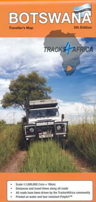
Tracks4Africa Wegenkaart Botswana – 5e editie (schaal 1:1.000.000)

De nieuwste wegenkaart van Botswana van Tracks4Africa, nu in de 5e editie, is een onmisbare metgezel voor iedereen die met een 4x4, camper of expeditievoertuig op pad gaat. Deze grote en gedetailleerde kaart is ontworpen als aanvulling op de T4A GPS-kaart van Botswana, maar werkt ook uitstekend zelfstandig.

Met een schaal van 1:1.000.000 (1 cm = 10 km) is dit de meest uitgebreide papieren kaart van Botswana die beschikbaar is. Alle wegen, van geasfalteerde routes tot zandsporen, zijn daadwerkelijk bereden en opgenomen met GPS door de Tracks4Africa-community – en dat al meer dan 10 jaar lang.

Belangrijkste kenmerken:

  • Schaal 1:1.000.000 – ideaal voor routeplanning en oriëntatie

  • Groot formaat: 1000 x 1265 mm wanneer uitgevouwen

  • Gedrukt op Polyart – scheurvast en waterbestendig, perfect voor outdoor gebruik

  • Afstanden én reistijden tussen plaatsen duidelijk aangegeven

  • Kaartlegenda en plaatsnamenregister inbegrepen

  • Alle wegen, tracks en interessante plekken zijn GPS-geregistreerd en gevalideerd

Gedetailleerde kaartinzetten van:

  • Okavango Delta

  • Savuti

  • Mabuasehube

  • Khwai (East & West)

  • Maun, Kasane, Gaborone (met stadskaart)

Extra informatie:

  • Informatie over rijden in Botswanabrandstofgrensposten en openingsuren

  • Campingetiquette, veiligheidstips en handige contactgegevens

  • Pictogrammen geven diensten en voorzieningen aan in grotere steden

  • Alles wat je op de kaart ziet komt ook voor in de T4A GPS-kaarten – geen dubbele invoer nodig

Voor wie is deze kaart bedoeld?

Deze Botswana reiskaart is ideaal voor:

  • 4x4-reizigers en overlanders

  • Camperreizigers en self-drivers

  • Safari-avonturiers en expeditiegangers

  • Wie reist door regio's als de Okavango, Moremi, Chobe, de Kalahari of Gaborone

  • Iedereen die offline wil navigeren met een betrouwbare en actuele papieren kaart

 5 Voordelen

  1. Zeer gedetailleerde schaal (1:1.000.000) – perfect voor het plannen van self-drive routes en overland trips.

  2. Water- en scheurvast materiaal (Polyart) – ideaal voor gebruik in ruige, stoffige of natte omstandigheden.

  3. Reistijden en afstanden vermeld – uniek voor een papieren kaart, zeer handig voor routeplanning.

  4. Alle wegen zijn GPS-geregistreerd – 100% betrouwbaar dankzij controle door de Tracks4Africa-community.

  5. Inclusief extra kaarten en stadsplattegronden – o.a. van de Okavango Delta, Maun, Kasane, Savuti en Gaborone.

 5 Aandachtspunten

  1. Engelstalige kaart – geen Nederlandstalige legenda of toelichting.

  2. Groot formaat (1000 x 1265 mm) – minder handig bij wind of beperkte ruimte.

  3. Geen topografische hoogtelijnen – niet geschikt voor wandel- of klimtochten.

  4. Niet interactief of digitaal – moet handmatig worden gelezen (maar werkt uitstekend offline).

  5. Aanvulling op T4A GPS vereist voor volledige navigatie – kaart en GPS werken het beste samen.

Wat zeggen reizigers over deze kaart? Samenvatting van de gebruikersreviews

Positieve punten

  • Robuust en duurzaam – De kaart bestaat uit Polyart (scheur- en watervast materiaal), wat handig is voor gebruik in de auto en in het veld dezwerver.nl.

  • Duidelijk en handig voor planning – Grote, overzichtelijke kaart met afstanden en geschatte reistijden tussen plaatsen, wat het eenvoudig maakt routes uit te stippelen dezwerver.nl.

  • Snelle levering en goede service – Gebruikers melden dat de kaart altijd keurig en op tijd werd bezorgddezwerver.nl.

Aandachtspunten

  • Formaat kan onhandig zijn tijdens de rit – De kaart is vrij groot en kan daarom wat lastig hanteren zijn in een voertuig .

  • Beperkte detailgraad in parken – Sommige gebruikers vinden oudere kaarten (zoals Shell) in natuurgebieden overzichtelijker dan deze kaart dezwerver.nl.

Conclusie

De Tracks4Africa wegenkaart voor Botswana scoort gemiddeld 4,6 sterren uit 14 beoordelingen. Hij wordt geprezen om zijn robuuste materiaal, duidelijke opmaak en handige toevoegingen zoals reistijden en afstanden. Perfect voor routeplanning en voorbereiding. Heb je echter een compacte kaart nodig tijdens het rijden, of ga je specifiek natuurparken in, dan kan het formaat of de detailgraad minder ideaal zijn.

Productinformatie

    Verken gerelateerde categorieën

    Webshop.nl maakt gebruik van cookies. Ga je verder op onze website, ga dan akkoord met het plaatsen van cookies en de verwerking van deze data door ons en vermelde partners.