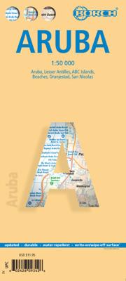
Wegenkaart - landkaart Aruba | Borch

0
Mooie, geplastificeerde kaart van Aruba. Deze kaart biedt een goed overzicht van het land met detailkaarten.   Our soft-laminated folded map of Aruba shows: Aruba 1:50 000, Beaches 1:25 000, Oranjestad 1:10 000, San Nicolas 1:20 000, ABC Islands 1:1 000 000, Lesser Antilles 1:7 000 000, Lesser Antilles time zones. Borch maps are easy to fold, dur...

Verkopers met dit product

Verkoper
Bezorging
Prijs
DeZwerver.nl logo
DeZwerver.nl
2,95
11,50

Anderen bekeken ook

Nieuw
Wegenkaart - landkaart Virgin Islands - Maagden eilanden | Borch
The soft-laminated map of the Virgin Islands includes: US Virgin Islands 1:80 000, St. Croix 1:80 000, Charlotte Amalie 1:15 000, Charlotte Amalie Historic District 1:7 500, Cruz Bay 1:15 000, Christiansted, Frederiksted 1:15 000, British Virgin Islands 1:80 000, Anegada 1:80 000, Road Town, The Valley (Spanish Town) 1:15 000, Lesser Antilles 1:7 000 000, Virgin Islands administrative / time zones; interesting statistics British / US Virgin Islands: conversion chart for temperatures, weights and measures; climate chart with temperatures, sunshine hours, precipitation and humidity; hotels, museums, markets and much more.   Virgin Islands is the name of two groups of small islands east of Puerto Rico which form the Virgin Islands archipelago. They lie between the Caribbean Sea and the Atlantic Ocean. One of the groups which consists of St. Croix, St. John and St. Thomas islands, together with many nearby islets, is called the U.S. Virgin Islands. The other group including Anegada, Jost …
11,50
Nieuw
Wegenkaart - landkaart Seychelles - Seychellen | Borch
Mooie geplasticieerde kaart vande Seychellen. Deze kaart biedt een goed overzicht van het land met detailkaarten.   Our soft-laminated folded map of Seychelles shows: Bird Island, Denis, Arid, Fregate 1:25 000, Mahe, Silhouette, Praislin, La Digue, Marianne, Desroches, North 1:50 000, Inner Islands 1:750 000, Seychelles 1:4 500 000, Victoria 1:13 000, Vallée de Mai 1:13 000 and Aldabra, Amirantes, Farquhar 1:2 500 000, Seychelles time zones. Borch Maps are easy to fold, durable and water-repellent with a wipeable surface. Borch Maps show hotels, museums, monuments, markets, public transport, top sights and points of interest, useful statistics, conversion charts for temperatures, weights and measurements, climate charts showing temperatures, sunshine hours, precipitation and humidity, overview maps, time zones, and much more...   The Republic of Seychelles is an archipelago of 115 granitic and coralline islands in the Indian Ocean, located east of Africa and northeast of Madagascar. S…
11,50
Nieuw
Wegenkaart - landkaart Spanje | Borch
Mooie geplasticieerde kaart van Spanje. Deze kaart biedt een goed overzicht van het land met detailkaarten.   Our soft-laminated folded map of Spain shows: Spain East 1:875 000, Spain West 1: 875 000, Canary Islands 1:1 875 000, Spain administrative and Europe time zones. Borch Maps are easy to fold, durable and water-repellent with a wipeable surface. Borch Maps show hotels, museums, monuments, markets, public transport, top sights and points of interest, useful statistics, conversion charts for temperatures, weights and measurements, climate charts showing temperatures, sunshine hours, precipitation and humidity, overview maps, time zones, and much more...   The Kingdom of Spain is the twelfth-largest economy in the world and was once the leading power and colonial empire in Europe. Spain has suffered its share of wars, invasions, inquisitions, and isolation, contributing to the rich and diverse culture that democratic Spain today represents. Its territory covers the central and eas…
11,50
Nieuw
Wegenkaart - landkaart Ecuador | Borch
Mooie geplasticieerde kaart van Ecuador. Deze kaart biedt een goed overzicht van het land met detailkaarten.   Our soft-laminated folded map of Ecuador shows: Ecuador West 1:1 000 000, Ecuador Est 1:2 000 000, Galapagos Islands1:1 300 000, Gran Quito 1:100 000, Quito 1:20 000, Cuenca 1:17 000, Guayaquil 1:18 000, Ecuador administrative and times zones. Borch maps are easy to fold, durable and water-repellent with a wipeable surface. Borch Maps show hotels, museums, monuments, markets, public transport, top sights and points of interest, useful statistics, conversion charts for temperatures, weights and measurements, climate charts showing temperatures, sunshine hours, precipitation and humidity, overview maps, time zones, and much more...   Dominated by the towering Andean range, Ecuador is a country of magnificent highlands, dramatic slopes, dense rainforests, fertile lowlands and tranquil sandy beaches. Its immense variety of landscapes and habitats support a unique flora and fauna …
11,50
Nieuw
Wegenkaart - landkaart Hawaiian Islands - Hawaiï | Borch
Mooie geplasticieerde kaart van Hawaiï. Deze kaart biedt een goed overzicht van deze eilanden met detailkaarten.   Our soft-laminated folded map of Hawaii shows: Hawaii (Big Island) 1:400 000, Kilauea Caldera 1:150 000, Hilo 1:70 000, Maui, Molokai / Lanai / Kahoolawe 1:200 000, Wailuku & Kahului 1:35 000, Hawaiian Islands 1:4 000 000, Niihau 1:400 000, Kauai / Oahu 1:200 000, Honolulu & Pearl Harbour 1:26 000, Honolulu Downtown 1:15 500, USA administrative & time zones. Borch Maps are easy to fold, durable and water-repellent with a wipeable surface. Borch Maps show hotels, museums, monuments, markets, public transport, top sights and points of interest, useful statistics, conversion charts for temperatures, weights and measurements, climate charts showing temperatures, sunshine hours, precipitation and humidity, overview maps, time zones, and much more...   Borne of fire and water barely 300 million years ago, the eight islands of the Hawaiian Archipelago together form the 50th US s…
11,50
Nieuw
Wegenkaart - landkaart Groot - Brittannië | Borch
Mooie geplasticieerde kaart van Groot - Brittanië. Deze kaart biedt een goed overzicht van het land met detailkaarten.   Our soft-laminated folded map of Great Britain shows: Scotland and Northern Ireland 1:800 000, England and Wales 1:800 000, Channel Crossings 1:800 000, Great Britain and Ireland administrative, Europe time zones. Borch Maps are easy to fold, durable and water-repellent with a wipeable surface. Borch Maps show hotels, museums, monuments, markets, public transport, top sights and points of interest, useful statistics, conversion charts for temperatures, weights and measurements, climate charts showing temperatures, sunshine hours, precipitation and humidity, overview maps, time zones, and much more...   "Great Britain", the largest island in Europe, is not one individual country, but the combination of Wales, England and Scotland. It also includes smaller islands such as the Hebrides, the Isle of Wight, Anglesy, the Isles of Scilly as well as the Shetland and Orkney …
11,50
Nieuw
Wegenkaart - landkaart USA Interstate | Borch
Mooie, overzichtelijke wegenkaart van de snelwegen in Amerika. Handig als je grote afstanden in het land moet afleggen.   Our soft-laminated folded map of the USA in the 9th edition shows: USA West, USA East, Hawaiian Islands, Puerto Rico each 1:4 000 000, Alaska 1:8 000 000, USA administrative & time zones. Borch Maps are easy to fold, durable and water-repellent with a wipeable surface. Borch Maps show hotels, museums, monuments, markets, public transport, top sights and points of interest, useful statistics, conversion charts for temperatures, weights and measurements, climate charts showing temperatures, sunshine hours, precipitation and humidity, overview maps, time zones, and much more...   "Get your motor running, head out on the highway"! The Interstate highway system (officially the "Dwight D. Eisenhower National System of Interstate and Defense Highways") authorized by the Federal Aid Highway Act of 1956 and supported by former US President Eisenhower who had been impressed …
11,50
Nieuw
Wegenkaart - landkaart Belize | Borch
Mooie, geplastificeerde kaart van Belize. Deze kaart biedt een goed overzicht van het land met detailkaarten.   Our soft-laminated folded map of Belize in the 5th edition shows: Belize 1:500 000, Belize City 1:13 000, San Ignacio & Santa Elena 1:25 000, Yucatan Peninsula 1: 2 750 000, Ambergris Caye & Caye Caulker 1:250 000, the Maya sites Altun Ha 1:3 000, Cahal Pech 1:2 500, Caracol 1:7 000, Cerros 1:4 000, El Pilar 1:8 000, Lamanai 1:9 000, Lubaantun 1:5 000, Nim Li Punit 1: 7 000, Xunantunich 1:7 000 and Belize administrative. Borch Maps are easy to fold, durable and water-repellent with a wipeable surface. Borch Maps show hotels, museums, monuments, markets, public transport, top sights and points of interest, useful statistics, conversion charts for temperatures, weights and measurements, climate charts showing temperatures, sunshine hours, precipitation and humidity, overview maps, and much more...   Known as British Honduras until about 1973, Belize is today no longer a Bri…
11,50
Nieuw
Wegenkaart - landkaart Thailand | Borch
Mooie geplasticieerde kaart van Thailand. Deze kaart biedt een goed overzicht van het land met detailkaarten van o.a. Bangkok, Phuket, Ko Samui. Our soft-laminated folded map of Thailand in the 8th edition shows: Thailand 1:1 500 000, Bangkok 1:22 000, Greater Bangkok 1:125 000, Chiang Mai 1:22 000, Mae Hong Son 1:14 000, Northwest Thailand 1:835 000, Phuket 1:350 000, Ko Samui & Ko Phangan 1:350 000, Thailand administrative & time zones. Borch Maps are easy to fold, durable and water-repellent with a wipeable surface. Borch Maps show hotels, museums, monuments, markets, public transport, top sights and points of interest, useful statistics, conversion charts for temperatures, weights and measurements, climate charts showing temperatures, sunshine hours, precipitation and humidity, overview maps, time zones, and much more...   Thailand - "Country of Liberty" - has every right to its name, as it is the only southeast Asian country never to have been ruled by a western colonial power…
11,50
Nieuw
Wegenkaart - landkaart Cuba | Borch
Mooie geplasticieerde kaart van Cuba. Deze kaart biedt een goed overzicht van het land met detailkaarten. Our soft-laminated map of Cuba includes: Cuba West 1:1 000 000, Cuba East 1:1000 000, La Habana 1:16 000, Varadero 1:25 000, Playas del Este 1:22 000, Santiago de Cuba 1:16 000, Cuba administrative & time zones. Borch Maps are easy to fold, durable and water-repellent with a wipeable surface. Borch Maps show hotels, museums, monuments, markets, public transport, top sights and points of interest, useful statistics, conversion charts for temperatures, weights and measurements, climate charts showing temperatures, sunshine hours, precipitation and humidity, overview maps, time zones, and much more...   The largest island in the Caribbean evokes images of blue, crystal-clear waters lapping against immaculate white beaches or revealing the colourful underwater life of the stunning reefs, cool courtyards enclosed by colonial buildings, stylish barmen mixing exotic, potent cocktails, an…
11,50

Klanten-reviews van Wegenkaart - landkaart Aruba | Borch

Er zijn nog geen beoordelingen voor dit productBen jij de eerste die een review plaatst?

Meer over Wegenkaart - landkaart Aruba | Borch

Productomschrijving

Mooie, geplastificeerde kaart van Aruba. Deze kaart biedt een goed overzicht van het land met detailkaarten.   Our soft-laminated folded map of Aruba shows: Aruba 1:50 000, Beaches 1:25 000, Oranjestad 1:10 000, San Nicolas 1:20 000, ABC Islands 1:1 000 000, Lesser Antilles 1:7 000 000, Lesser Antilles time zones. Borch maps are easy to fold, durable and water-repellent with a wipeable surface. Borch Maps show hotels, museums, monuments, markets, public transport, top sights and points of interest, useful statistics, conversion charts for temperatures, weights and measurements, climate charts showing temperatures, sunshine hours, precipitation and sea temperatures, overview maps, time zones, and much more...   Aruba is the westernmost of the "ABC" islands (Aruba, Bonaire, Curaçao) and approximately 30 km off the coast of Venezuela. Sun-aficionados know these islands are home to probably the most beautiful sand beaches of the Caribbean. Wind and water conditions are ideal for the international windsurfing competitions held here and divers can enjoy the colourful splendour of protected reefs in crystal clear waters. The impressive cliffs of the east coast and the Arikok National Park are ideal for walks. Luxurious accommodation in the many excellent hotels (shown on our map), international cuisine in countless restaurants, as well as great entertainment in the casinos, ensure an exciting yet laid-back Caribbean vacation!  

Verken gerelateerde categorieën

Webshop.nl maakt gebruik van cookies. Ga je verder op onze website, ga dan akkoord met het plaatsen van cookies en de verwerking van deze data door ons en vermelde partners.