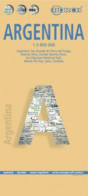
Wegenkaart - landkaart Argentinië - Argentina | Borch

0
Mooie, geplastificeerde kaart van het Argentinië. Deze kaart biedt een goed overzicht van het land met detailkaarten.   Our soft-laminated folded map of Argentina shows: Argentina 1:3 800 000, Isla Grande de Tierra del Fuego 1:1 900 000, Los Glaciares National Park 1:750 000, Mount Fitz Roy 1: 250 000, Greater Buenos Aires 1:650 000, Buenos Aires ...

Verkopers met dit product

Verkoper
Bezorging
Prijs
DeZwerver.nl logo
DeZwerver.nl
2,95
11,50

Anderen bekeken ook

Wegenkaart - landkaart Argentinië - Argentina | Borch
Mooie, geplastificeerde kaart van het Argentinië. Deze kaart biedt een goed overzicht van het land met detailkaarten.   Our soft-laminated folded map of Argentina shows: Argentina 1:3 800 000, Isla Grande de Tierra del Fuego 1:1 900 000, Los Glaciares National Park 1:750 000, Mount Fitz Roy 1: 250 000, Greater Buenos Aires 1:650 000, Buenos Aires 1:18 000, Cordoba 1:14 000, Salta 1:16 000, Argentina administrative and time zones. Borch Maps are easy to fold, durable and water-repellent with a wipeable surface. Borch Maps show hotels, museums, monuments, markets, public transport, top sights and points of interest, useful statistics, conversion charts for temperatures, weights and measurements, climate charts showing temperatures, sunshine hours, precipitation and humidity, overview maps, time zones, and much more...   Enchanted by the sophisticated European flair of Buenos Aires, watching the world go by from a sidewalk café whilst taking a break from the buzzing nightlife, one could …
11,50
Wegenkaart - landkaart 3400 Adventure Map Argentina - Argentinië | National Geographic
Wegenkaart van Argentinië met vermelding van veel bezienswaardigheden, nationale parken en attrakties. Watervast en scheurvast. Juist door deze vermeldingen onderscheidt de kaart zich van andere wegenkaarten. National Geographic's Argentina Adventure Map is designed to meet the unique needs of adventure travelers—detailed, durable, and accurate. Argentina includes the locations of thousands of major cities and towns with an index for easily locating them, plus a clearly marked road network complete with distances and designations for major highways, limited access highways, minor roads, and more.   What sets National Geographic Adventure Maps apart from traditional road maps are the hundreds of points-of-interest that highlight the diverse, unique, and exotic destinations within Argentina including national parks and preserves, World Heritage sites, archeological sites, churches of interest, scenic viewpoints, natural points of interest, and important travel aids like airports, airstr…
17,50
Reisgids Argentina - Argentinië | Lonely Planet
De perfecte reisgids voor zowel de georganiseerde als de zelfstandige reiziger. Naast een algemene inleiding van het land / streek vol met praktische informatie over hoe je er het beste kunt reizen: slapen, eten, vervoer, excursies ... alles kun je er in vinden. LET OP: Met 50 pagina's over Uruguay!! Lonely Planet's local travel experts reveal all you need to know to plan the trip of a lifetime to Argentina.   Discover popular and off the beaten track experiences from marvelling at Iguazú Falls jaw-dropping waterfalls with rainbows, to watching whales leap out of the water on Playa Las Canteras, and dancing the tango at a traditional Buenos Aires milonga.   Build a trip to remember with Lonely Planet's Argentina travel guide:   Our classic guidebook format provides you with the most comprehensive level of information for planning multi-week trips Updated with an all new structure and design so you can navigate Argentina and connect experiences together with ease Create your p…
27,50
Wegenkaart - landkaart Buenos Aires | Borch
Borch Buenos Aires is een duidelijke, geplastificeerde plattegrond van het centrum met informatie over openbaar vervoer en bezienswaardigheden. Inclusief straatnamenregister.   Our soft-laminated folded map of Buenos Aires in the 7th edition shows: Buenos Aires Centre 1:15 000, Isla Martín Garcia 1:18 000, Núnez 1:15 000, Boca 1:15 000, Buenos Aires 1:75 000, Greater Buenos Aires 1:530 000, Argentina Central 1:3 000 000, Public Transport Buenos Aires, Argentina administrative and time zones, Top 30 Sights. Borch Maps are easy to fold, durable and water-repellent with a wipeable surface. Borch Maps show hotels, museums, monuments, markets, public transport, top sights and points of interest, useful statistics, conversion charts for temperatures, weights and measurements, climate charts showing temperatures, sunshine hours, precipitation and humidity, overview maps, time zones, and much more...   Buenos Aires, located on the Rio de la Plata inlet on the southeastern side of the South Am…
9,95
Wegenkaart - landkaart Argentinië - Noord en Uruguay | Nelles Verlag
Goede kaart van het noorden van Argentinie met Uruguay. Aan beide kanten bedrukt. Met veel toeristische aanduidingen als nationale parken en culturele bezienswaardigheden. Prima leesbare kaart. Folded road and tourist map of Northern Argentina and Uruguay at 1:2 500 000 scale. All of Uruguay is covered and Argentina is covered from the northern border south past Bahia Blanca on the eastern coast. Places of interest and national parks are highlighted and shaded-relief colouring clearly depicts topography.    The map includes insets showing central Montevideo at 1:12 500, Tucuman at 1:30 000, Cordoba at 1:16 000, Iguacu at 1:450 000, central Buenos Aires at 1:20 000, greater Buenos Aires at 1:750 000 and a locator map. The legend is in English, German, Spanish and French.   For over 20 years Nelles maps have been renowned throughout the world for their quality, faithfulness to detail and up-to-dateness.    So that streets, ferry links, railway lines, etc are always up to date, Nelles ar…
11,95
Reisgids Argentina - Argentinië | Rough Guides
Zeer goede reisgids voor zowel de georganiseerde maar vooral voor de zelfstandige reiziger. Boordevol informatie over reizen, slapen, eten, maar ook musea en cultuur. Uitputtende bron van informatie, veelal nog completer dan de Lonely Planet. Inleidende informatie over land en cultuur is zeer goed. Ideal for independent travellers, this guidebook to Argentina, written by destination experts, combines must-see sights with hidden gems and offers essential tips for both planning and on-the-ground adventures. It's sustainably printed to ensure environmental responsibility.   Inside this Argentina travel book, you'll find:   - Regional deep dive - coverage of key regions, offering a rich selection of places and experiences, and honest reviews of each one - Itinerary samples - designed for various durations and interests - Practical information - tips on how to get there and get around, use public transport, beat the crowds, save time and money, travel responsibly and more - Expert …
27,50
Wegenkaart - landkaart Argentina South & Tierra Del Fuego | ITMB
  Een degelijke kaart met aanduidingen van o.a. nationale parken, vliegveld, benzinepomp, dirt-roads etc. Als overzichtskaart goed te gebruiken.   Op één kant van de kaart staat het zuiden van Argentinië (schaal 1:2.200.00) en op de andere kant staat Tierra del Fuego (schaal 1:750.000).   We have switched focus from Northern Argentina and Buenos Aires to Southern Argentina and Tierra del Fuego. This long stretch of South America's second largest country lies beside Chile and is home to many whales and sea lions watching sites. Throughout this long strip of a combination of mountains, seas, and forests, tourists will find this land to be unique and natural. On the other side of this map and at the very end of the two countries sits the famous Land of Fire island, Tierra del Fuego. This triangle shaped island is both part of Chile and Argentina and has been a desirable tourist destination. We have also included an inset map of Ushuaia, "the southernmost city in the world" that is closes…
13,95
Reisgids Argentinie - Argentina | Insight Guides
Een rijk geillustreerde reisgids met diepgaande teksten: één van de beste reisgidsen die er bestaan. Eerste deel bestaat uit een beschrijving van de unieke aspecten van de regio, daarna een deel echte reisgids en als afsluiting een deel met praktische informatie. De uitstekende informatie wordt vergezeld van prachtige foto's en heldere kaarten. Niet alleen om mee te nemen, maar ook om vooraf en zelfs achteraf weer in de stemming te komen This Argentina guidebook is ideal for travellers seeking inspirational guides and planning a more extended trip. It provides interesting facts about Argentina's people, history and culture and detailed coverage of the best places to see. This Argentina travel book has the style of an illustrated magazine to inspire you and give a taste of Argentina. The book is printed on paper from responsible sources, and verified to meet FSC's strict environmental and social standards. This Argentina guidebook covers: Buenos Aires, Around Buenos Aires, Mar y Sierra…
25,95
Wegenkaart - landkaart Argentina - Argentinie | ITMB
Een degelijke kaart met aanduidingen van o.a. nationale parken, vliegveld, dirt-roads en kleine plattegrond van hoofdstad. Als overzichtskaart goed te gebruiken.   This edition of Argentina represents a significant updating of the road network. Argentina is aggressively redeveloping the country's infrastructure, investing in new schools, hospitals, and water supplies, as well as paving hundreds of kilometers of dirt highways annually. No map can be completely up to date as a result, as new segments of newly-paved roadway comes 'on stream' weekly; however, we've done our best to show off this fast-changing country to good advantage.   Legend Includes: Roads by classification, Airports, Ferries, Train Stations, Bus Terminals, Subway Stations, Lighthouses, Beaches, Ruins, Mines, Points of Interest, Police Stations, Gas Stations, Museums, Universities, Churches, Post Offices, Depertment Stores, Theatres, Embassies, Hospitals and more.  
13,95
Wegenkaart - landkaart 788 Chili - Argentinië | Michelin
Zoals je van Michelin mag verwachten is deze kaart zeer overzichtelijk en heeft een duidelijk helder kaartbeeld. De kaart geeft uitgebreide toeristische informatie weer. De perfecte overzichtskaart!   This Chili - Argentinie map from Michelin is part of their red national map series. These are perfect for route planning as well as getting around by car once you're there. They clearly mark out major roads and also show many of the more important minor roads. A street plan of central Buenos Aires that highlights the city's mai attractions is included.   The map's simple folding design with durable paper cover, allows it to be read like a book and easily folded back together. Road numbers and intermediate distances are clearly displayed with the more scenic routes highlighted in green.   The map also features:   Political boundaries Regional and National Parks Important sights (points of interest, historic sites, etc.) Driving Times and Distances Road Safety Information A legend in multi…
12,95

Klanten-reviews van Wegenkaart - landkaart Argentinië - Argentina | Borch

Er zijn nog geen beoordelingen voor dit productBen jij de eerste die een review plaatst?

Meer over Wegenkaart - landkaart Argentinië - Argentina | Borch

Productomschrijving

Mooie, geplastificeerde kaart van het Argentinië. Deze kaart biedt een goed overzicht van het land met detailkaarten.   Our soft-laminated folded map of Argentina shows: Argentina 1:3 800 000, Isla Grande de Tierra del Fuego 1:1 900 000, Los Glaciares National Park 1:750 000, Mount Fitz Roy 1: 250 000, Greater Buenos Aires 1:650 000, Buenos Aires 1:18 000, Cordoba 1:14 000, Salta 1:16 000, Argentina administrative and time zones. Borch Maps are easy to fold, durable and water-repellent with a wipeable surface. Borch Maps show hotels, museums, monuments, markets, public transport, top sights and points of interest, useful statistics, conversion charts for temperatures, weights and measurements, climate charts showing temperatures, sunshine hours, precipitation and humidity, overview maps, time zones, and much more...   Enchanted by the sophisticated European flair of Buenos Aires, watching the world go by from a sidewalk café whilst taking a break from the buzzing nightlife, one could almost forget that the land of tango, pampas, and legendary gauchos has more to offer than just charming clichés. Windsurfers, sun-worshippers and fishing enthusiasts enjoy the fabulous surf and broad sandy beaches around Mar del Plata. Cuyo, Argentina's wine country, offers outdoor activity all year round - from trekking and hang-gliding to waterskiing and sailing. In Patagonia, the eastern slopes of the Andes create a breathtaking landscape of towering volcanoes, shimmering lakes and sprawling forests - unforgettable sights for nature lovers who will be delighted by the abundant wildlife on Península Váldes, the jagged glacial peaks on windswept Tierra del Fuego, and the thunderous cascades of the Iguazú Falls. The scenic desert canyons in the northwest, with their colonial churches and largely indigenous population, ensure an authentically Andean experience.  

Productinformatie

    Verken gerelateerde categorieën

    Webshop.nl maakt gebruik van cookies. Ga je verder op onze website, ga dan akkoord met het plaatsen van cookies en de verwerking van deze data door ons en vermelde partners.