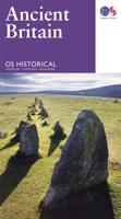
Wegenkaart - landkaart Ancient Britain | Ordnance Survey

0
The Ordnance Survey Ancient Britain map is a comprehensive guide to the most important archaeological sites of early English, Welsh and Scottish history. Ordnance Survey's Ancient Britain map shows Neolithic, Bronze Age, Iron Age, Roman and early Medieval sites – against a backdrop of modern mapping. This extract shows some of the ancient sites of...

Verkopers met dit product

Verkoper
Bezorging
Prijs
DeZwerver.nl logo
DeZwerver.nl
2,95
13,50

Anderen bekeken ook

Nieuw
Wegenkaart - landkaart Roman Britain | Ordnance Survey
An informative map showing the location of the most important ancient monuments of Roman Britain. The map has been produced by Ordnance Survey in collaboration with the Ancient Monument Trusts of England, Scotland and Wales, so as to provide an authoritative map of the historical sights of Great Britain. It also contains valuable background details on life in Britain during this formative period. This Ordnance Survey Historical map and guide is a fascinating possession for the interested and enthusiastic historians of today.
12,95
Nieuw
Wandelgids Walking in the Thames Valley | Cicerone
Walking in the Thames Valley offers 25 challenging circular walks around the River Thames and River Kennet in the south of England, taking in the Southern Chilterns, the Berkshire and North Hampshire Downs, Southern Oxfordshire and the eastern edge of Wiltshire. All routes are within easy reach of Reading, Newbury, Abingdon and London. While some walks visit Iron Age hill forts, others pass more modern features such as Wilton Windmill and the Kennet and Avon Canal. Some follow sections of the Ridgeway, while others meander along the banks of the Thames. What they all have in common is that they take the keen rambler to some of the best parts of the Thames Valley – a patchwork of open chalk grassland, broadleaved woodland and farmland and home to two Areas of Outstanding Natural Beauty. • walks from 10 to 18 miles, including one 2-day route • shorter, less strenuous alternatives for many of the walks • detailed route descriptions with information on local points of interest, OS mapping…
18,50
Wandelkaart - Topografische kaart 170 OS Explorer Map Abingdon, Wantage & Vale of White Horse | Ordnance Survey
Discover the Vale of White Horse, rolling hills dominated by the extraordinary, eponymous White Horse, an enigmatic Bronze Age chalk carving which can be seen for miles leaping across the hillside. Explore the historic market towns of Abingdon-on-Thames, dating back to Saxon times; Wantage, birthplace of King Alfred the Great; Wallingford and Faringdon, known for its 100-foot high folly tower.     Visit the iconic White Horse and the ancient landscape that surrounds it, including Uffington Castle and Dragon Hill, where St George slew the dragon  Follow streams flowing through the chalk uplands and discover unique locations like the Manger and its Giant Steps, remnants of the Ice Age  Walk, hike or cycle along the ancient Ridgeway through the wold or a number of other popular recreational paths including sections of the Thames Path, Lambourn Valley Way and Chiltern Way    Met zijn 4cm voor 1 km (2 ½ cm voor 1 mijl) schaal, is de OS Explorer kaartenserie de ideale en meest gedetaille…
19,50
Nieuw
Wegenkaart - landkaart Jersey - Guernsey - Sark - Alderney (Kanaaleilanden) | ITMB
Goede detailkaart van alle kanaaleilanden. Het is zo gedetailleerd dat zelfs straatnamen er op staan. De kaart is ook nog eens geplastificeerd en daarmee scheur- en watervast.  ITMB is pleased to re-introduce the Channel Islands map area after a lengthy hiatus of preparing new artwork. The first version of this part of Europe was licensed artwork by a local firm in Jersey, and upon running out of copies of the printed map, we opted to prepare fresh artwork of our own to continue this interesting corner of the continent to continue to be available. The islands, collectively known in English as the Channel Islands, are one of those anomalies that make Europe so attractive. They are part of Great Britain, but not part of the UK; hence, they are not part of the EU. They are self-governing entities ‘owned’ by the Queen in her role of being Duchess of Normandy. This is, of course, merely a hereditary situation, but the islands were the personal possessions of William the Conqueror in 1066, …
14,50
Wegenkaart - landkaart 10 Road Map Britain Britain - Groot Brittannië | AA Publishing
Goede dubbelzijdige overzichtskaart met plaatsnamenregister  van heel Engeland met Schotland erbij. Britain’s clearest mapping from the experts at the AA, in a handy foldable map. Fully updated, this map of Britain combines clear design and an easy-to-read scale with more road detail to ensure that you never lose your way. The map includes information on toll points, service areas, road numbers, motorways, dual carriageways and wide and narrow local roads. National Parks, and places of interest are also highlighted. Caravan and camping sites pinpointed on the mapping. City and town plans Easy-to-read place index name. Part of a range of 9 regional sheet maps plus 1 map covering the whole of Britain. Map Series - 1 West Country & Wales. 2 Central Southern England. 3 South East England. 4 East Anglia. 5 Midlands & Central England. 6 Wales. 7 Northern England. 8 North England & Scottish Borders. 9 Scotland. 10 Britain.    
10,95
Nieuw
Wandelkaart - Topografische kaart 170 OS Explorer Map | Active Abingdon / Wantage / Vale | Ordnance Survey
Discover the Vale of White Horse, rolling hills dominated by the extraordinary, eponymous White Horse, an enigmatic Bronze Age chalk carving which can be seen for miles leaping across the hillside. Explore the historic market towns of Abingdon-on-Thames, dating back to Saxon times; Wantage, birthplace of King Alfred the Great; Wallingford and Faringdon, known for its 100-foot high folly tower.     Visit the iconic White Horse and the ancient landscape that surrounds it, including Uffington Castle and Dragon Hill, where St George slew the dragon  Follow streams flowing through the chalk uplands and discover unique locations like the Manger and its Giant Steps, remnants of the Ice Age  Walk, hike or cycle along the ancient Ridgeway through the wold or a number of other popular recreational paths including sections of the Thames Path, Lambourn Valley Way and Chiltern Way    Met zijn 4cm voor 1 km (2 ½ cm voor 1 mijl) schaal, is de OS Explorer kaartenserie de ideale en meest gedetailleerd…
25,95
Wegenkaart - landkaart 6 Road Map Britain Wales | AA Publishing
Goede dubbelzijdige wegenkaart met plaatsnamenindex van Wales Britain’s clearest mapping from the experts at the AA, in a handy foldable map. Fully updated, this map of Wales combines clear design and an easy-to-read scale with more road detail to ensure that you never lose your way. This map of Wales includes information on toll points, service areas, road numbers, motorways, dual carriageways and wide and narrow local roads. National Parks, and places of interest are also highlighted. Caravan and camping sites pinpointed on the mapping. City and town plans Easy-to-read place index name. Part of a range of 9 regional sheet maps plus 1 map covering the whole of Britain. Map Series - 1 West Country & Wales. 2 Central Southern England. 3 South East England. 4 East Anglia. 5 Midlands & Central England. 6 Wales. 7 Northern England. 8 North England & Scottish Borders. 9 Scotland. 10 Britain.  
10,95
Wegenkaart - landkaart 7 Road Map Britain Northern England | AA Publishing
Goede dubbelzijdige wegenkaart met plaatsnamenindex van noord Engeland. Grof geschetst is het een rechthoek tussen Penrith, Hartlepool, Lincoln en Chester. Britain’s clearest mapping from the experts at the AA, in a handy foldable map. Fully updated, this map of Northern England combines clear design and an easy-to-read scale with more road detail to ensure that you never lose your way. The map includes information on toll points, service areas, road numbers, motorways, dual carriageways and wide and narrow local roads. National Parks, and places of interest are also highlighted. Caravan and camping sites pinpointed on the mapping. City and town plans Easy-to-read place index name. Part of a range of 9 regional sheet maps plus 1 map covering the whole of Britain. Map Series - 1 West Country & Wales. 2 Central Southern England. 3 South East England. 4 East Anglia. 5 Midlands & Central England. 6 Wales. 7 Northern England. 8 North England & Scottish Borders. 9 Scotland. 10 Britain.  
10,95
Wegenkaart - landkaart 4 Road Map Britain East Anglia | AA Publishing
Goede dubbelzijdige wegenkaart met  plaatsnamenindex van East Anglia. Grof geschetst is het een rechthoek tussen Lincoln, Norwich, Ipswich en Luton Britain’s clearest mapping from the experts at the AA, in a handy foldable map. Fully updated, this map of East Anglia combines clear design and an easy-to-read scale with more road detail to ensure that you never lose your way. The map includes information on toll points, service areas, road numbers, motorways, dual carriageways and wide and narrow local roads. National Parks, and places of interest are also highlighted. Caravan and camping sites pinpointed on the mapping. City and town plans Easy-to-read place index name. Part of a range of 9 regional sheet maps plus 1 map covering the whole of Britain. Map Series - 1 West Country & Wales. 2 Central Southern England. 3 South East England. 4 East Anglia. 5 Midlands & Central England. 6 Wales. 7 Northern England. 8 North England & Scottish Borders. 9 Scotland. 10 Britain.  
10,95
Wegenkaart - landkaart 9 Road Map Britain Scotland - Schotland | AA Publishing
Goede dubbelzijdige wegenkaart van Schotland met plaatsnamen index. Britain’s clearest mapping from the experts at the AA, in a handy foldable map. Fully updated, this map of Scotland combines clear design and an easy-to-read scale with more road detail to ensure that you never lose your way. The map includes information on toll points, service areas, road numbers, motorways, dual carriageways and wide and narrow local roads. National Parks, and places of interest are also highlighted. Caravan and camping sites pinpointed on the mapping. City and town plans Easy-to-read place index name. Part of a range of 9 regional sheet maps plus 1 map covering the whole of Britain. Map Series - 1 West Country & Wales. 2 Central Southern England. 3 South East England. 4 East Anglia. 5 Midlands & Central England. 6 Wales. 7 Northern England. 8 North England & Scottish Borders. 9 Scotland. 10 Britain.  
10,95

Klanten-reviews van Wegenkaart - landkaart Ancient Britain | Ordnance Survey

Er zijn nog geen beoordelingen voor dit productBen jij de eerste die een review plaatst?

Meer over Wegenkaart - landkaart Ancient Britain | Ordnance Survey

Productomschrijving

The Ordnance Survey Ancient Britain map is a comprehensive guide to the most important archaeological sites of early English, Welsh and Scottish history.

Ordnance Survey's Ancient Britain map shows Neolithic, Bronze Age, Iron Age, Roman and early Medieval sites – against a backdrop of modern mapping. This extract shows some of the ancient sites of Wiltshire marked on the map.

The secrets of Ancient Britain are to be revealed in a revised Historical map and guide from Ordnance Survey.

Aimed at anyone with an interest in the early history of Britain – from schoolchildren through to archaeologists and tourists – the map helps bring the past to life.

Information on the map includes ancient roads and place names – as well as comprehensive features and illustrations on many aspects of life in the period, including land use and settlement sites. Photographs, showing how many of the sites look today, are also used to give context.

The map is created in conjunction with The National Monuments Record of English Heritage, the Royal Commission on the Ancient and Historical Monuments of Scotland and the Royal Commission on the Ancient and Historical Monuments of Wales. It features the whole of Great Britain on a double-sided sheet and shows the detailed history of ancient Britain – including the Neolithic, Bronze Age, Iron Age, Roman and early Medieval periods – against a backdrop of modern Ordnance Survey mapping.

Verken gerelateerde categorieën

Webshop.nl maakt gebruik van cookies. Ga je verder op onze website, ga dan akkoord met het plaatsen van cookies en de verwerking van deze data door ons en vermelde partners.