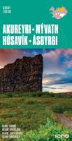
Wegenkaart - landkaart Akureyri - Mývatn - Húsavík - Ásbyrgi | Ferdakort

0
Topografische overzichtskaart 1:200.000 Akureyri / Mývatn / Húsavík / Ásbyrgi special map in het noorden van IJsland - Ferðakort ( vroeger Landmaelingar Íslands ) De wegenkaart laat de toeristisch interessante gebieden rond Akureyri, Husavik , het meer Myvatn en Asbyrgi met de rivier Jökulsa zien. Met verhard en onverhard wegennet hoogtelijnen, ov...

Verkopers met dit product

Verkoper
Bezorging
Prijs
DeZwerver.nl logo
DeZwerver.nl
2,95
21,50

Anderen bekeken ook

Nieuw
Wegenkaart - landkaart Snaefellsnes - Borgarfjordur (special map IJsland) | Ferdakort
Topografische overzichtskaart 1:200.000 Snæfellsnes / Borgarfjörður - special map in het westen van IJsland - Ferðakort ( vroeger Landmaelingar Íslands ) De wegenkaart laat de toeristisch interessante gebieden op het schiereiland Snaefellsnes en rond Borgarnes zien. Met verhard en onverhard wegennet hoogtelijnen, overnachtingsplekken, hutten voor wandelaars, campings, bezienswaardigheden etc. This high quality map shows the most popular tourist area in Iceland. The map includes photographs and information about the most visited places in the area. The map uses latest geographical data to produce an excellent up-to-date source of information on regional tourist attractions, roads, and services.
21,50
Wegenkaart - landkaart Brisbane to Cairns | Hema Maps
Detailkaart van een deel van Australië. Zeer goed leesbaar, met naast de topografische details veel symbolen waarmee allerhande toeristische zaken worden aangeduid als campsites, nationale parken, attracties, wandelmogelijkheden etc. An easy-to-follow map that shows both the coastal and inland routes from Brisbane to Cairns. Roadside rest areas, intermediate distances, and a quick-find distance chart are also shown. The map shows all the popular tourist destinations along the Queensland coast. Routes between Brisbane with Cairns in a series of touring maps connecting Australia’s main centres of population along some of the most spectacular routes such as the Great Ocean Road or the Savannah Way. The maps highlight 24-hour fuel supplies, roadside rest areas, camping facilities, places of interest, etc., and include distance charts and, in some titles, city maps. Road network indicates unsurfaced roads and tracks. The maps also show railway lines. There is no topographical information b…
17,50
Wegenkaart - landkaart Mexico Central & Mexico City | ITMB
Goede wegenkaart met duidelijk kleurgebruik. Het betreft een deel van Mexico met op de achterkant een stadsplattegrond van het centrale deel van Mexico City. MC is the largest city in the Western Hemisphere, with a population of 28,000,000 (or twice as big as New York City!). It would be impractical to portray the entire urban area on one map and have it make sense, so we show the portion of greatest interest to visitors, from the Chapultepec Zoological Park in the west to the incredibly busy Tapo Bus Terminal in the east, and from the railway station in the north to the southern east-west motorway just south of the main hospital complex. Much of MC’s touristic interest is concentrated in the Zona Rosa, Reforma, and Zocalo segments of the city centre, and these are shown in detail, noting hotels, major restaurants, shopping areas, and points of interest.   The map also includes inset maps of the San Angel area just north of the university, an inset map of the greater Mexico City Feder…
13,95
Nieuw
Wegenkaart - landkaart South West Western Australia | Hema Maps
Hema's South West Western Australia Map features unequalled road and track information for this picturesque corner in Australia's largest state. A regional map for discovering South West Western Australia (WA). On the reverse side of the map are detailed inset maps of Nambung National Park, Avon Valley National Park, Lane Poole Reservation, the South West Corner, Stirling Range National Park, D, Entrecastreaux National Park and Albany Coast. Also included is tourist information for the Coral Coast, Perth, Avon Valley, the Great Southern Region, Peel, Blackwood River Valley, the Southern Forests, the Margaret River region and the Southern Coast.   The southwestern portion of Western Australia has a spectacular coastline, great surfing beaches, flowing rivers, tall forests, wineries, farms, quaint towns, bustling cities and numerous other attractions. While forest communities remain quiet, the coastal area from Bunbury to Margaret River and Augusta bursts at the seams on long weekend…
17,50
Wegenkaart - landkaart Chobe | Shell
Zeer bijzondere goede landkaart van Chobe National Park in Botswana. Uitermate handig zijn de GPS coordinaten van de meest belangrijke punten als campings of uitzichtpunten. De kaart is gebaseerd op een luchtfoto, waarbij alle details zijn ingetekend. The map: The Chobe map consists of a complete map of Chobe on the front of the map and there are 5 individual maps of the major tourist areas on the back of the map. These are Chobe river front east, Chobe river front west, Nogatsaa, Savute and a small orientation map. The map was compiled by using satellite images, giving one a birds eye-view of the area. The roads were tracked by means of a GPS and then super-imposed on the photographs. Detailed GPS co-ordinates are supplied for game-drive areas. The Chobe map contains 126 GPS co-ordinates. The four main tourist areas: The Chobe National Park consists of a variety of vegetation types and geological features, offering extreme contrasts and a wide range of wildlife experiences within the…
17,50
Nieuw
Wegenkaart - landkaart Namibia - Namibië | Tracks4Africa
Uitstekende dubbelzijdige wegenkaart van Namibië, gemaakt door gerenommeerde kaartenmaker Track4Africa in Afrika. Met afstanden en reistijden tussen steden en op alle wegen vermeld. GPS via hun website te downloaden. De kaart wordt door vrijwel elke reisorganisatie geadviseerd als je met een eigen auto in Namibië rond gaat rijden. The Tracks4Africa Namibia paper map is designed to be used in conjunction with the T4A GPS Map of Namibia. It is the largest available Namibia map at 1:1,000,000 scale, offering you the perfect trip planning tool for your next Namibian holiday.  This T4A paper map series are probably the first comprehensive country maps in the world, offering travel time information for the entire road network, be it on tar, gravel or sand!    Key features:    Large 1:1,000,000 scale  Travel times and distances included on the map  What you see on the paper map is exactly what you get on T4A GPS Maps  Comprehensive set of roads and tracks in nature reserves  Detailed in…
27,50
Wegenkaart - landkaart Québec | ITMB
Een degelijke kaart met aanduidingen van o.a. nationale parken, vliegvelden en grote wegen. Als overzichtskaart goed te gebruiken. Tweezijdig. La Belle Province is historically rich, linguistically unique in North America, and attractive for tourism. It is a very large area of land, forcing us to portray the northern portion at a different scale than the more populated southern portion. The map extends to Ottawa in the west and includes most of New Brunswick in the east, as well as all the border areas with the USA to the south. Due to the size of Quebec, the focus of this map is concentrated on providing road information to get around, parks and geographic features, and symbols portraying ski resort areas, urban areas, and road numbers. A basic inset showing the major routes around Montreal is an added feature.   Legend Includes: Roads by classification, Points of Interest, Mines, Museums, Airports, National Parks, Rivers, Lakes, Mountain Peaks, Waterfalls, Border Crossings, Rest Are…
13,95
Wegenkaart - landkaart New England and New York State | ITMB
Goede dubbelzijdige wegenkaart waarbij met kleurgebruik de hoogte en natuurkundige aspecten wat duidelijker wordt weergegeven dan op andere kaarten. De wegen worden aangeduid met de bekende wegnummers en afstanden tussen steden staan weergegeven. Met symbolen worden toeristisch belangrijke aspecten getoond en ook bijvoorbeeld campings. Nationale parken zijn goed terug te vinden op deze kaart.  ITMB expands its coverage of the USA with a detailed map of New York State and New England on a double-sided map at a very detailed scale. The one side covers most of the state and the southern portion of the New England states, along with an inset map of the greater NYC area, the other side covers from Boston and Cape cod to the northern extremes of Maine and west into Vermont, with inset maps of Boston and Boston Region. The reality of mapping the USA is that it is too large a country and too populous to be mapped in detail except by regions. As a sophisticated economy, it has thousands of tow…
13,95
Nieuw
Wegenkaart - landkaart Turistkort Danmark med Margueritruten + bykort - Margrietroute | Scanmaps
Nordisk Korthandel has published a new Tourist Map of Denmark and Major Cities with The Marguerite Route.   As a newly added feature the Tourist map of Denmark includes the scenic Marguerite Route.   The Marguerite route is a 3600 km long route through the danish landscape, and was opened in 1991 by Queen Margrethe of Denmark. The route runs through beautiful regions of Denmark, and in most places it is possible to cycle or walk along the route. Most of the route is situated on small roads, and therefore it is not the quickest or shortest way from point A to B, but instead it is an invitation to visit the many attractions, that you will find in Denmark. It runs through the danish mainland and is therefore not covering islands like Bornholm and Samsø. If you want to leave the mainland, you can find information, on ferry routes that depart from danish harbours, on the map.   The route uses the daisy flower as a symbol, and you will find it on the road signs, that are placed alongside th…
24,95
Wandelkaart - Topografische kaart 179 OS Explorer Map Gloucester, Cheltenham, Stroud | Ordnance Survey
The essential map for outdoor activities in Gloucester, Cheltenham and Stroud. The OS Explorer Map is the Ordnance Survey's most detailed folding map and is recommended for anyone enjoying outdoor activities including walking, horse riding and off-road cycling. This map now comes with a digital version which you can download to your smartphone or tablet.Providing complete GB coverage, the OS Explorer map series details information essential in the great outdoors, including youth hostels, pubs and visitor information. Rights of way, fences, permissive paths and bridleways are clearly shown, ensuring you have the best information to get the most out of your time in the countryside. FeaturesCotswold Way Severn Way Gloucestershire Way Macmillan Way Wysis WayCotswold Way (National Trail) GloucesterCheltenhamGloucester Stroud1:25 000 scale (4 cm to 1 km - 2.5 inches to 1 mile) Met zijn 4cm voor 1 km (2 ½ cm voor 1 mijl) schaal, is de OS Explorer kaartenserie de ideale en meest gedetailleerd…
19,50

Klanten-reviews van Wegenkaart - landkaart Akureyri - Mývatn - Húsavík - Ásbyrgi | Ferdakort

Er zijn nog geen beoordelingen voor dit productBen jij de eerste die een review plaatst?

Meer over Wegenkaart - landkaart Akureyri - Mývatn - Húsavík - Ásbyrgi | Ferdakort

Productomschrijving

Topografische overzichtskaart 1:200.000 Akureyri / Mývatn / Húsavík / Ásbyrgi special map in het noorden van IJsland - Ferðakort ( vroeger Landmaelingar Íslands )

De wegenkaart laat de toeristisch interessante gebieden rond Akureyri, Husavik , het meer Myvatn en Asbyrgi met de rivier Jökulsa zien.

Met verhard en onverhard wegennet hoogtelijnen, overnachtingsplekken, hutten voor wandelaars, campings, bezienswaardigheden etc.

This high quality map shows the most popular tourist area in Iceland. The map includes photographs and information about the most visited places in the area. The map uses latest geographical data to produce an excellent up-to-date source of information on regional tourist attractions, roads, and services.

Productinformatie

    Verken gerelateerde categorieën

    Webshop.nl maakt gebruik van cookies. Ga je verder op onze website, ga dan akkoord met het plaatsen van cookies en de verwerking van deze data door ons en vermelde partners.