webshop.nl
Categorieën
  Sluiten

Meer National Geographic

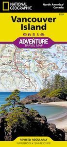
Wegenkaart - landkaart Adventure Travel Map Vancouver Island | Nationa

Wegenkaart van Vancouver Island met vermelding van veel bezienswaardigheden, nationale parken en attrakties. Watervast en scheurvast. Juist door deze vermeldingen onderscheidt de kaart zich van andere wegenkaarten. National Geographic's Vancouver Island Adventure Map provides global travelers with the perfect combination of detail and perspective i...
17,50

Webshops met dit product

Webshop
Bezorging
Prijs

Anderen bekeken ook

Wegenkaart - landkaart Adventure Travel Map Vancouver Island | Nationa
Wegenkaart van Vancouver Island met vermelding van veel bezienswaardigheden, nationale parken en attrakties. Watervast en scheurvast. Juist door deze vermeldingen onderscheidt de kaart zich van andere wegenkaarten. National Geographic's Vancouver Island Adventure Map provides global travelers with the perfect combination of detail and perspective in a highly functional travel tool. Cities and towns are clearly indicated and easy to find in the user-friendly index. A road network complete with distances and designations for roads, motorways, and expressways will help you find the route that's right for you. Secondary routes are also marked for those seeking to explore off the beaten path. Hundreds of points of interest and diverse and unique destinations are highlighted including national parks, nature reserves, World Heritage sites, archeological sites, ski areas, hot springs, beaches, museums, and more.   The south side of the print map shows Victoria the capital of British Columbia, …
17,50
Wegenkaart - landkaart 3329 Adventure Travel Map Denmark - Denemarken
Wegenkaart van Denemarken met vermelding van veel bezienswaardigheden, nationale parken en attrakties. Watervast en scheurvast. Juist door deze vermeldingen onderscheidt de kaart zich van andere wegenkaarten. Denmark's more than 100 islands, the largest of which are connected by a series of long bridges and tunnels with National Geographic's Denmark Adventure Map. Designed to meet the needs of adventure travelers with its detailed, accurate information, this map includes the location of cities and towns with a user-friendly index and a clearly marked road network complete with distances and designations for motorways, major routes, and roads. In addition, side roads and tracks are shown for those seeking to explore off the beaten path. Hundreds of points of interest that highlight the diverse, unique, and exotic destinations within the country such as national parks and reserves, wildlife parks, World Heritage sites, and archeological sites. Important travel aids like airports, airfiel…
17,50
Wegenkaart - landkaart 3315 Adventure Map Corsica | National Geographi
Wegenkaart van Corsica met vermelding van veel bezienswaardigheden, nationale parken en attrakties. Watervast en scheurvast. Juist door deze vermeldingen onderscheidt de kaart zich van andere wegenkaarten. National Geographic's Corsica Adventure Map is designed to meet the unique needs of adventure travelers with its durability and accurate information. Each folded map provides global travelers with the perfect combination of detail and perspective, highlighting the area’s terrain and best locations for adventure activities like snorkeling, surfing, fishing, and more. Adventure Maps include hundreds of points of interest that highlight diverse and unique destinations within the country.   The map includes the locations of thousands of cities and towns with a user-friendly index, plus a clearly marked road network complete with distances and designations for major highways, main roads, and tracks and trails for those seeking to explore more remote regions. The front side of the Corsica …
17,50
Wegenkaart - landkaart 3313 Adventure Map France - Frankrijk | Nationa
Wegenkaart van Frankrijk met vermelding van veel bezienswaardigheden, nationale parken en attrakties. Watervast en scheurvast. Juist door deze vermeldingen onderscheidt de kaart zich van andere wegenkaarten. National Geographic's France Adventure Map is designed to meet the unique needs of adventure travelers with its durability and accurate information. Each folded map provides global travelers with the perfect combination of detail and perspective, highlighting the area’s terrain and best locations for adventure activities like snorkeling, surfing, fishing, and more. Adventure Maps include hundreds of points of interest that highlight diverse and unique destinations within the country. The map includes the locations of thousands of cities and towns with a user-friendly index, plus a clearly marked road network complete with distances and designations for major highways, main roads, and tracks and trails for those seeking to explore more remote regions. Adventure Maps are printed in t…
17,50
Wegenkaart - landkaart 3318 Adventure Map Cyprus | National Geographic
Wegenkaart van Cyprus met vermelding van veel bezienswaardigheden, nationale parken en attrakties. Watervast en scheurvast. Juist door deze vermeldingen onderscheidt de kaart zich van andere wegenkaarten. National Geographic's Cyprus Adventure Map is designed to meet the unique needs of adventure travelers with its durability and accurate information. This folded map provides global travelers with the perfect combination of detail and perspective, highlighting hundreds of points of interest and the diverse and unique destinations within the country.   The front side of the Cyprus map shows the western portion of the island. This side details the regions of Paphos, Limassol, Nicosia, Larnaca, and Kyrenia. The reverse side of the map shows the eastern part of the island. This side details the regions of Larnaca, Kyrenia, and Famagusta. The map includes the locations of cities and towns with a user-friendly index, plus a clearly marked road network complete with distances and designations…
17,50
Wegenkaart - landkaart 3300 Adventure Map Finland & Northern Scandinav
Wegenkaart van Finland en noord Scandinavië met vermelding van veel bezienswaardigheden, nationale parken en attrakties. Watervast en scheurvast. Juist door deze vermeldingen onderscheidt de kaart zich van andere wegenkaarten. National Geographic's Finland and Northern Scandinavia Adventure Map is designed to meet the unique needs of adventure travelers with its detail, durability, and accuracy. Scandinavia North includes the locations of thousands of cities and towns with an index for easily locating them, plus a clearly marked road network complete with distances and designations for expressways, motorways, and more. What sets National Geographic Adventure Maps apart from traditional road maps are the hundreds of points of interest that highlight the diverse and unique destinations within northern Scandinavia. World Heritage sites, museums, amusement parks, zoos, castles, archeological sites, churches, and more are included, making it invaluable to travelers hoping to experience all …
17,50

Klanten-reviews van Wegenkaart - landkaart Adventure Travel Map Vancouver Island | Nationa

Er zijn nog geen beoordelingen voor dit productBen jij de eerste die een review plaatst?

Meer over Wegenkaart - landkaart Adventure Travel Map Vancouver Island | Nationa

Productomschrijving

Wegenkaart van Vancouver Island met vermelding van veel bezienswaardigheden, nationale parken en attrakties. Watervast en scheurvast. Juist door deze vermeldingen onderscheidt de kaart zich van andere wegenkaarten. National Geographic's Vancouver Island Adventure Map provides global travelers with the perfect combination of detail and perspective in a highly functional travel tool. Cities and towns are clearly indicated and easy to find in the user-friendly index. A road network complete with distances and designations for roads, motorways, and expressways will help you find the route that's right for you. Secondary routes are also marked for those seeking to explore off the beaten path. Hundreds of points of interest and diverse and unique destinations are highlighted including national parks, nature reserves, World Heritage sites, archeological sites, ski areas, hot springs, beaches, museums, and more.   The south side of the print map shows Victoria the capital of British Columbia, Pacific Rim National Park Reserve, and the costal town of Nanaimo. The northern half of the printed map covers the much more remote part of the island. There are many large protected areas in the north of the island including Strathcona, Cape Scott, Tahsish-Kwois Provincial Parks.   Every Adventure Map is printed on durable synthetic paper, making them waterproof, tear-resistant and tough -- capable of withstanding the rigors of international travel.

Productspecificaties

Artikelnummer(s)
Brand
National Geographic
Webshop.nl maakt gebruik van cookies. Ga je verder op onze website, ga dan akkoord met het plaatsen van cookies en de verwerking van deze data door ons en vermelde partners.