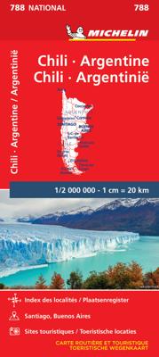
Wegenkaart - landkaart 788 Chili - Argentinië | Michelin

0
Zoals je van Michelin mag verwachten is deze kaart zeer overzichtelijk en heeft een duidelijk helder kaartbeeld. De kaart geeft uitgebreide toeristische informatie weer. De perfecte overzichtskaart!   This Chili - Argentinie map from Michelin is part of their red national map series. These are perfect for route planning as well as getting around b...

Verkopers met dit product

Verkoper
Bezorging
Prijs
DeZwerver.nl logo
DeZwerver.nl
2,95
12,95

Anderen bekeken ook

Wegenkaart - landkaart 788 Chili - Argentinië | Michelin
Zoals je van Michelin mag verwachten is deze kaart zeer overzichtelijk en heeft een duidelijk helder kaartbeeld. De kaart geeft uitgebreide toeristische informatie weer. De perfecte overzichtskaart!   This Chili - Argentinie map from Michelin is part of their red national map series. These are perfect for route planning as well as getting around by car once you're there. They clearly mark out major roads and also show many of the more important minor roads. A street plan of central Buenos Aires that highlights the city's mai attractions is included.   The map's simple folding design with durable paper cover, allows it to be read like a book and easily folded back together. Road numbers and intermediate distances are clearly displayed with the more scenic routes highlighted in green.   The map also features:   Political boundaries Regional and National Parks Important sights (points of interest, historic sites, etc.) Driving Times and Distances Road Safety Information A legend in multi…
12,95
Wegenkaart - landkaart 3400 Adventure Map Argentina - Argentinië | National Geographic
Wegenkaart van Argentinië met vermelding van veel bezienswaardigheden, nationale parken en attrakties. Watervast en scheurvast. Juist door deze vermeldingen onderscheidt de kaart zich van andere wegenkaarten. National Geographic's Argentina Adventure Map is designed to meet the unique needs of adventure travelers—detailed, durable, and accurate. Argentina includes the locations of thousands of major cities and towns with an index for easily locating them, plus a clearly marked road network complete with distances and designations for major highways, limited access highways, minor roads, and more.   What sets National Geographic Adventure Maps apart from traditional road maps are the hundreds of points-of-interest that highlight the diverse, unique, and exotic destinations within Argentina including national parks and preserves, World Heritage sites, archeological sites, churches of interest, scenic viewpoints, natural points of interest, and important travel aids like airports, airstr…
17,50
Wegenkaart - landkaart Argentinië - Noord en Uruguay | Nelles Verlag
Goede kaart van het noorden van Argentinie met Uruguay. Aan beide kanten bedrukt. Met veel toeristische aanduidingen als nationale parken en culturele bezienswaardigheden. Prima leesbare kaart. Folded road and tourist map of Northern Argentina and Uruguay at 1:2 500 000 scale. All of Uruguay is covered and Argentina is covered from the northern border south past Bahia Blanca on the eastern coast. Places of interest and national parks are highlighted and shaded-relief colouring clearly depicts topography.    The map includes insets showing central Montevideo at 1:12 500, Tucuman at 1:30 000, Cordoba at 1:16 000, Iguacu at 1:450 000, central Buenos Aires at 1:20 000, greater Buenos Aires at 1:750 000 and a locator map. The legend is in English, German, Spanish and French.   For over 20 years Nelles maps have been renowned throughout the world for their quality, faithfulness to detail and up-to-dateness.    So that streets, ferry links, railway lines, etc are always up to date, Nelles ar…
11,95
Wegenkaart - landkaart Argentinië - Argentina | Borch
Mooie, geplastificeerde kaart van het Argentinië. Deze kaart biedt een goed overzicht van het land met detailkaarten.   Our soft-laminated folded map of Argentina shows: Argentina 1:3 800 000, Isla Grande de Tierra del Fuego 1:1 900 000, Los Glaciares National Park 1:750 000, Mount Fitz Roy 1: 250 000, Greater Buenos Aires 1:650 000, Buenos Aires 1:18 000, Cordoba 1:14 000, Salta 1:16 000, Argentina administrative and time zones. Borch Maps are easy to fold, durable and water-repellent with a wipeable surface. Borch Maps show hotels, museums, monuments, markets, public transport, top sights and points of interest, useful statistics, conversion charts for temperatures, weights and measurements, climate charts showing temperatures, sunshine hours, precipitation and humidity, overview maps, time zones, and much more...   Enchanted by the sophisticated European flair of Buenos Aires, watching the world go by from a sidewalk café whilst taking a break from the buzzing nightlife, one could …
11,50
Wegenkaart - landkaart 766 Canada | Michelin
Zoals je van Michelin mag verwachten is deze kaart zeer overzichtelijk en heeft een duidelijk helder kaartbeeld. De kaart geeft uitgebreide toeristische informatie weer. De perfecte overzichtskaart!   This Canada map from Michelin is part of their red national map series. These are perfect for route planning as well as getting around by car once you're there. They clearly mark out major roads and also show many of the more important minor roads.    The map's simple folding design with durable paper cover, allows it to be read like a book and easily folded back together. Road numbers and intermediate distances are clearly displayed with the more scenic routes highlighted in green.   The map also features:   Political boundaries Regional and National Parks Important sights (points of interest, historic sites, etc.) Driving Times and Distances Road Safety Information A legend in multiple languages (Dutch, English, French, German and Spanish)   Canada, Edmonton, Inuvik, Montréal, Ottawa, …
12,95
Wegenkaart - landkaart 765 Mexico | Michelin
Zoals je van deze landkaart van Michelin mag verwachten is deze wegenkaart Mexico zeer overzichtelijk en heeft een duidelijk helder kaartbeeld. De kaart geeft uitgebreid toeristische informatie weer. This Mexico map from Michelin is part of their red national map series. These are perfect for route planning as well as getting around by car once you're there. They clearly mark out major roads and also show many of the more important minor roads. A map of Mexico City and environs is included as an inset as is a more detail street plan of the centre of the city.   The map's simple folding design with durable paper cover, allows it to be read like a book and easily folded back together. Road numbers and intermediate distances are clearly displayed with the more scenic routes highlighted in green.   The map also features:   Political boundaries Regional and National Parks Important sights (points of interest, historic sites, etc.) Driving Times and Distances Road Safety Information A legen…
12,95
Wegenkaart - landkaart 764 Bresil - Brazilië | Michelin
Zoals je van Michelin mag verwachten is deze kaart zeer overzichtelijk en heeft een duidelijk helder kaartbeeld. De kaart geeft uitgebreide toeristische informatie weer. De perfecte overzichtskaart! This Brazil map from Michelin is part of their red national map series. These are perfect for route planning as well as getting around by car once you're there. They clearly mark out major roads and also show many of the more important minor roads.   The map's simple folding design with durable paper cover, allows it to be read like a book and easily folded back together. Road numbers and intermediate distances are clearly displayed with the more scenic routes highlighted in green.   The map also features:   Political boundaries Regional and National Parks Important sights (points of interest, historic sites, etc.) Driving Times and Distances Road Safety Information A legend in multiple languages (Dutch, English, French, German and Spanish)   Brésil, Rio de Janeiro, Salvador, Sao Paulo
12,95
Wegenkaart - landkaart 737 Griekenland | Michelin
Zoals je van Michelin mag verwachten is deze kaart zeer overzichtelijk en heeft een duidelijk helder kaartbeeld. De kaart geeft uitgebreid toeristische informatie weer. Met register, afstanden en reistijden. Wegen worden naar verschillende klasse ingedeeld en - mooi van Michelin - de interessante mooie routes worden gemarkeerd met een groene streep.    Hindernissen voor automobilisten met caravans zijn gemarkeerd: steile hellingen, bergpassen of een anderzins moeilijke route. Bezienswaardigheden als een kasteel, religieus gebouw, ruine of grot is door een symbool goed te vinden. This Greece map from Michelin is part of their red national map series. These are perfect for route planning as well as getting around by car once you're there. They clearly mark out major roads and also show many of the more important minor roads.   The map's simple folding design with durable paper cover, allows it to be read like a book and easily folded back together. Road numbers and intermediate distance…
11,95
Wegenkaart - landkaart 781 Baltische Staten | Michelin
Zoals je van deze landkaart van Michelin mag verwachten is deze wegenkaart Baltische Staten zeer overzichtelijk en heeft een duidelijk helder kaartbeeld. De kaart geeft uitgebreid toeristische informatie weer. This Baltic States map from Michelin is part of their red national map series. These are perfect for route planning as well as getting around by car once you're there. They clearly mark out major roads and also show many of the more important minor roads. The map covers Estonia, Latvia, and Lithuania and includes several insets showing Tallinn at 1:10 000, Riga at 1:10 000 and Vinius at 1:10 000.   The map's simple folding design with durable paper cover, allows it to be read like a book and easily folded back together. Road numbers and intermediate distances are clearly displayed with the more scenic routes highlighted in green.   The map also features:   Political boundaries Regional and National Parks Important sights such as castles, ruins, and churches Driving Times and Dis…
11,95
Wegenkaart - landkaart 735 Italië 2025 | Michelin
Zoals je van Michelin mag verwachten is deze kaart zeer overzichtelijk en heeft een duidelijk helder kaartbeeld. De kaart geeft uitgebreid toeristische informatie weer. Met register, afstanden en reistijden. Wegen worden naar verschillende klasse ingedeeld en - mooi van Michelin - de interessante mooie routes worden gemarkeerd met een groene streep.    Hindernissen voor automobilisten met caravans zijn gemarkeerd: steile hellingen, bergpassen of een anderzins moeilijke route. Bezienswaardigheden als een kasteel, religieus gebouw, ruine of grot is door een symbool goed te vinden. This Italy map from Michelin is part of their red national map series. These are perfect for route planning as well as getting around by car once you're there. They clearly mark out major roads and also show many of the more important minor roads.    The map's simple folding design with durable paper cover, allows it to be read like a book and easily folded back together. Road numbers and intermediate distance…
11,95

Klanten-reviews van Wegenkaart - landkaart 788 Chili - Argentinië | Michelin

Er zijn nog geen beoordelingen voor dit productBen jij de eerste die een review plaatst?

Meer over Wegenkaart - landkaart 788 Chili - Argentinië | Michelin

Productomschrijving

Zoals je van Michelin mag verwachten is deze kaart zeer overzichtelijk en heeft een duidelijk helder kaartbeeld. De kaart geeft uitgebreide toeristische informatie weer. De perfecte overzichtskaart!   This Chili - Argentinie map from Michelin is part of their red national map series. These are perfect for route planning as well as getting around by car once you're there. They clearly mark out major roads and also show many of the more important minor roads. A street plan of central Buenos Aires that highlights the city's mai attractions is included.   The map's simple folding design with durable paper cover, allows it to be read like a book and easily folded back together. Road numbers and intermediate distances are clearly displayed with the more scenic routes highlighted in green.   The map also features:   Political boundaries Regional and National Parks Important sights (points of interest, historic sites, etc.) Driving Times and Distances Road Safety Information A legend in multiple languages (Dutch, English, French, German and Spanish)   Argentine, Buenos Aires, Chili, Santiago


Productinformatie

    Verken gerelateerde categorieën

    Webshop.nl maakt gebruik van cookies. Ga je verder op onze website, ga dan akkoord met het plaatsen van cookies en de verwerking van deze data door ons en vermelde partners.