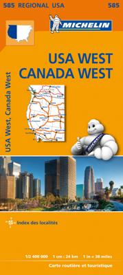
Wegenkaart - landkaart 585 Western USA - Western Canada | Michelin

0
Wegenkaart van het westelijke gedeelte van de USA (zuid tot bovenste stukje Mexico, oost tot ongeveer Denver/ Regina) en westelijk Canada (t/m Edmonton in het noorden). Zie uitsnede op de voorkant van de kaart. Primary & secondary road networks are clearly marked out with indications of the number of lanes, intermediate distances and various poss...

Verkopers met dit product

Verkoper
Bezorging
Prijs
DeZwerver.nl logo
DeZwerver.nl
2,95
12,95

Anderen bekeken ook

Wegenkaart - landkaart 585 Western USA - Western Canada | Michelin
Wegenkaart van het westelijke gedeelte van de USA (zuid tot bovenste stukje Mexico, oost tot ongeveer Denver/ Regina) en westelijk Canada (t/m Edmonton in het noorden). Zie uitsnede op de voorkant van de kaart. Primary & secondary road networks are clearly marked out with indications of the number of lanes, intermediate distances and various possible road obstacles or things you should know including steep hills, height limits, toll barriers, prohibited roads and roads subject to restrictions.   The map also includes small insets with street plans of the regions major towns, showing road names, one way streets and various places of interest (tourist sights, hospitals, parking, railway stations, etc.). Scenic routes on the map are marked out in green and an extensive index of place names is included.   The map also features:   Administrative boundaries Railways, Airports and Ferry Services Important sights such as castles, ruins, and churches Driving Times and Distance Charts…
12,95
Wegenkaart - landkaart 583 Northeastern USA, Eastern Canada | Michelin
Wegenkaart van het noordoostelijke gedeelte van de USA (Kansas City - Fargo - Boston - Washington DC) en zuidoost Canada (Québec - Montréal - Ottawa - Winnipeg - Regina). Zie uitsnede op de voorkant van de kaart. Primary & secondary road networks are clearly marked out with indications of the number of lanes, intermediate distances and various possible road obstacles or things you should know including steep hills, height limits, toll barriers, prohibited roads and roads subject to restrictions.   The map also includes small insets with street plans of the regions major towns, showing road names, one way streets and various places of interest (tourist sights, hospitals, parking, railway stations, etc.). Scenic routes on the map are marked out in green and an extensive index of place names is included.   The map also features:   Administrative boundaries Railways, Airports and Ferry Services Important sights such as castles, ruins, and churches Driving Times and Distance Cha…
12,95
Wegenkaart - landkaart 584 Southeastern USA - Zuidoost USA | Michelin
Wegenkaart van zuidoostelijk Amerika (zuid vanaf Torreon en Saltillo, west El Paso en Albuquerque, noord in een lijn van Denver naar Washington DC. Primary & secondary road networks are clearly marked out with indications of the number of lanes, intermediate distances and various possible road obstacles or things you should know including steep hills, height limits, toll barriers, prohibited roads and roads subject to restrictions.   The map also includes small insets with street plans of the regions major towns, showing road names, one way streets and various places of interest (tourist sights, hospitals, parking, railway stations, etc.). Scenic routes on the map are marked out in green and an extensive index of place names is included.   The map also features:   Administrative boundaries Railways, Airports and Ferry Services Important sights such as castles, ruins, and churches Driving Times and Distance Charts Road Safety Information A legend in multiple languages, including Englis…
12,95
Wegenkaart - landkaart Western Canada | ITMB
Een degelijke kaart met aanduidingen van o.a. nationale parken, vliegveld, benzinepomp, dirt-roads. Als overzichtskaart goed te gebruiken. This is actually our second attempt at mapping the western portion of Canada; the first covered everything from northwestern Ontario to the Pacific Ocean and, while it was an excellent map, the scale that such a huge area covered necessitated severe problems. In this version, all of British Columbia, Alberta, and the Yukon have been mapped from fresh digital data and presented at 1:1.4T scale. This would have been impossible when we prepared the first map. The Northwest Territories portion had to be compressed in two ways; first, the scale is 1:2M; second, only the portion with roads is shown. This is still an extremely large area. One has to consider the actual size of Canada when designing a map. Most countries in Europe would fit into this area, which only covers 20% of Canada. The Fort McMurray forest fire of a year ago covered an area larger t…
13,95
Wegenkaart - landkaart 766 Canada | Michelin
Zoals je van Michelin mag verwachten is deze kaart zeer overzichtelijk en heeft een duidelijk helder kaartbeeld. De kaart geeft uitgebreide toeristische informatie weer. De perfecte overzichtskaart!   This Canada map from Michelin is part of their red national map series. These are perfect for route planning as well as getting around by car once you're there. They clearly mark out major roads and also show many of the more important minor roads.    The map's simple folding design with durable paper cover, allows it to be read like a book and easily folded back together. Road numbers and intermediate distances are clearly displayed with the more scenic routes highlighted in green.   The map also features:   Political boundaries Regional and National Parks Important sights (points of interest, historic sites, etc.) Driving Times and Distances Road Safety Information A legend in multiple languages (Dutch, English, French, German and Spanish)   Canada, Edmonton, Inuvik, Montréal, Ottawa, …
12,95
Wegenkaart - landkaart 582 Mid Atlantic - Allegheny Highlands - noordwest USA | Michelin
Zoals je van Michelin mag verwachten zijn het onmisbare overzichtskaarten van een uitstekende kwaliteit: een duidelijk en goed leesbaar kaartbeeld.  Vrijwel alle berijdbare wegen staan er op ingetekend, in kleur verschillend voor grote en kleine wegen. Andere weginformatie omvat bijvoorbeeld kilometer-afstanden, tolwegen, helling-aanduiding, winterafsluitingen, tankstations maar ook de bekende groene routes: de mooiste wegen om te rijden.   Daarnaast geeft de kaart toeristische informatie met symbolen weer: bezienswaardigheden als kastelen, kloosters, musea. De kaart is voorzien van een 4-talige legenda. Toch hebben de makers door een beperkt gebruik van symbolen geen drukke kaart gemaakt. De kracht zit hem dan ook in de combinatie van meer dan voldoende informatie en goede leesbaarheid.  Part of the orange regional series from Michelin, this Midatlantic, Allegheny Highlands map shows this part of North America in excellent detail. Primary & secondary road networks are clearly marked …
12,95
Wegenkaart - landkaart 543 Nordrhein-Westfalen | Michelin
Zoals je van Michelin mag verwachten zijn het onmisbare overzichtskaarten van een uitstekende kwaliteit: een duidelijk en goed leesbaar kaartbeeld.  Vrijwel alle berijdbare wegen staan er op ingetekend, in kleur verschillend voor grote en kleine wegen. Andere weginformatie omvat bijvoorbeeld kilometer-afstanden, tolwegen, helling-aanduiding, winterafsluitingen, tankstations maar ook de bekende groene routes: de mooiste wegen om te rijden.   Daarnaast geeft de kaart toeristische informatie met symbolen weer: bezienswaardigheden als kastelen, kloosters, musea, maar ook campings (niet allemaal overigens). De kaart is voorzien van een 4-talige legenda.   Toch hebben de makers door een beperkt gebruik van symbolen geen drukke kaart gemaakt. De kracht zit hem dan ook in de combinatie van meer dan voldoende informatie en goede leesbaarheid.  Part of the orange regional series from Michelin, this Germany Midwest map shows this part of Germany in excellent detail. Primary & secondary road netw…
11,95
Wegenkaart - landkaart 581 New England - Hudson Valley | Michelin
Zoals je van Michelin mag verwachten zijn het onmisbare overzichtskaarten van een uitstekende kwaliteit: een duidelijk en goed leesbaar kaartbeeld.  Vrijwel alle berijdbare wegen staan er op ingetekend, in kleur verschillend voor grote en kleine wegen. Andere weginformatie omvat bijvoorbeeld kilometer-afstanden, tolwegen, helling-aanduiding, winterafsluitingen, tankstations maar ook de bekende groene routes: de mooiste wegen om te rijden.   Daarnaast geeft de kaart toeristische informatie met symbolen weer: bezienswaardigheden als kastelen, kloosters, musea. De kaart is voorzien van een 4-talige legenda. Toch hebben de makers door een beperkt gebruik van symbolen geen drukke kaart gemaakt. De kracht zit hem dan ook in de combinatie van meer dan voldoende informatie en goede leesbaarheid.  Part of the orange regional series from Michelin, this New England, Hudson Valley map shows this part of North America in excellent detail. Primary & secondary road networks are clearly marked out wi…
12,95
Wegenkaart - landkaart 545 Baden Wurtemberg, Duitsland Zuid-West | Michelin
Zoals je van Michelin mag verwachten zijn het onmisbare overzichtskaarten van een uitstekende kwaliteit: een duidelijk en goed leesbaar kaartbeeld.  Vrijwel alle berijdbare wegen staan er op ingetekend, in kleur verschillend voor grote en kleine wegen. Andere weginformatie omvat bijvoorbeeld kilometer-afstanden, tolwegen, helling-aanduiding, winterafsluitingen, tankstations maar ook de bekende groene routes: de mooiste wegen om te rijden.   Daarnaast geeft de kaart toeristische informatie met symbolen weer: bezienswaardigheden als kastelen, kloosters, musea, maar ook campings (niet allemaal overigens). De kaart is voorzien van een 4-talige legenda.   Toch hebben de makers door een beperkt gebruik van symbolen geen drukke kaart gemaakt. De kracht zit hem dan ook in de combinatie van meer dan voldoende informatie en goede leesbaarheid.  Part of the orange regional series from Michelin, this Germany Southwest map shows this part of Germany in excellent detail. Primary & secondary road ne…
11,95
Wegenkaart - landkaart 544 Thuringen - Sachsen | Michelin
Zoals je van Michelin mag verwachten is deze kaart zeer overzichtelijk en heeft een duidelijk helder kaartbeeld. De kaart geeft uitgebreid toeristische informatie weer. Part of the orange regional series from Michelin, this Germany Mideast map shows this part of Germany in excellent detail. Primary & secondary road networks are clearly marked out with indications of the number of lanes, intermediate distances and various possible road obstacles or things you should know including steep hills, height limits, toll barriers, prohibited roads and roads subject to restrictions.   The map also includes small insets with street plans of Dresden, Leipzig and Erfurt, showing road names, one way streets and various places of interest (tourist sights, hospitals, parking, railway stations, etc.). Scenic routes on the map are marked out in green and an extensive index of place names is included.   The map also features:   Administrative boundaries Railways, Airports and Ferry Services Important si…
11,95

Klanten-reviews van Wegenkaart - landkaart 585 Western USA - Western Canada | Michelin

Er zijn nog geen beoordelingen voor dit productBen jij de eerste die een review plaatst?

Meer over Wegenkaart - landkaart 585 Western USA - Western Canada | Michelin

Productomschrijving

Wegenkaart van het westelijke gedeelte van de USA (zuid tot bovenste stukje Mexico, oost tot ongeveer Denver/ Regina) en westelijk Canada (t/m Edmonton in het noorden). Zie uitsnede op de voorkant van de kaart.

Primary & secondary road networks are clearly marked out with indications of the number of lanes, intermediate distances and various possible road obstacles or things you should know including steep hills, height limits, toll barriers, prohibited roads and roads subject to restrictions.   The map also includes small insets with street plans of the regions major towns, showing road names, one way streets and various places of interest (tourist sights, hospitals, parking, railway stations, etc.). Scenic routes on the map are marked out in green and an extensive index of place names is included.   The map also features:   Administrative boundaries Railways, Airports and Ferry Services Important sights such as castles, ruins, and churches Driving Times and Distance Charts Road Safety Information A legend in multiple languages, including English

Californie, Canada, Colorado, Etats-Unis, Nord-Ouest américain, Ouest canadien, Sud-Ouest américain

Productinformatie

    Verken gerelateerde categorieën

    Webshop.nl maakt gebruik van cookies. Ga je verder op onze website, ga dan akkoord met het plaatsen van cookies en de verwerking van deze data door ons en vermelde partners.