webshop.nl
Categorieën
  Sluiten

Meer National Geographic
Meer National Geographic in Literatuur boeken

Wegenkaart - landkaart 3407 Adventure Map Uruguay - Paraguay | Nationa

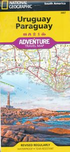
Wegenkaart van Uruguay en Paraguay  met vermelding van veel bezienswaardigheden, nationale parken en attrakties. Watervast en scheurvast. Juist door deze vermeldingen onderscheidt de kaart zich van andere wegenkaarten. Let National Geographic's Uruguay and Paraguay Adventure Map guide you as you explore the unique biodiversity, rich history and vib...
17,50

Webshops met dit product

Webshop
Bezorging
Prijs

Anderen bekeken ook

Wegenkaart - landkaart 3407 Adventure Map Uruguay - Paraguay | Nationa
Wegenkaart van Uruguay en Paraguay  met vermelding van veel bezienswaardigheden, nationale parken en attrakties. Watervast en scheurvast. Juist door deze vermeldingen onderscheidt de kaart zich van andere wegenkaarten. Let National Geographic's Uruguay and Paraguay Adventure Map guide you as you explore the unique biodiversity, rich history and vibrant culture of these two South American countries. Quickly find your destination with the aid of a user-friendly index of cities and towns. Then plan your route using the mapped road network, complete with distances and designations for major and secondary roads, as well as tracks and unsurfaced roads for those seeking to travel off the beaten path. Other travel network features include airports, airfields, railroads, harbors and border crossings. In addition, hundreds of cultural, historical, ecological and recreational points of interest are pinpointed, such as UNESCO World Heritage Sites, protected areas, beaches, waterfalls, camping, and…
17,50
Wegenkaart - landkaart 3400 Adventure Map Argentina - Argentinië | Nat
Wegenkaart van Argentinië met vermelding van veel bezienswaardigheden, nationale parken en attrakties. Watervast en scheurvast. Juist door deze vermeldingen onderscheidt de kaart zich van andere wegenkaarten. National Geographic's Argentina Adventure Map is designed to meet the unique needs of adventure travelers—detailed, durable, and accurate. Argentina includes the locations of thousands of major cities and towns with an index for easily locating them, plus a clearly marked road network complete with distances and designations for major highways, limited access highways, minor roads, and more.   What sets National Geographic Adventure Maps apart from traditional road maps are the hundreds of points-of-interest that highlight the diverse, unique, and exotic destinations within Argentina including national parks and preserves, World Heritage sites, archeological sites, churches of interest, scenic viewpoints, natural points of interest, and important travel aids like airports, airstri…
17,50
Wegenkaart - landkaart Argentinië noord - Argentina North & Uruguay |
Een degelijke kaart met aanduidingen van o.a. nationale parken, vliegveld, benzinepomp, dirt-roads en kleine plattegrond van hoofdstad. Als overzichtskaart goed te gebruiken.   At ITMB, we are excited to present our first attempt of combining Argentina North and Uruguay on a travel map. For our map of Argentina North, we have display significant updating of the road network. Argentina is aggressively redeveloping the country's infrastructure, investing in new schools, hospitals, and water supplies, as well as paving hundreds of kilometres of dirt highways annually. No map can be completely up to date as a result, as new segments of newly-paved roadway comes 'on stream' weekly; however, we've done our best to show off this fast-changing country to good advantage. Our 4th edition Uruguay map mostly contains minor updates to the layout of the previous edition. We have added an inset of the capital Montevideo as well. Uruguay is still one of the most economically developed countries in Sou…
13,95
Wegenkaart - landkaart 3014 Adventure Map India South - Zuid | Nationa
Wegenkaart van Zuid India met vermelding van veel bezienswaardigheden, nationale parken en attrakties. Watervast en scheurvast. National Geographic's India South Adventure Map is designed to meet the unique needs of adventure travelers with its durability and detailed, accurate information. The map includes the locations of thousands of cities and towns with a user-friendly index, as well as a clearly marked road network complete with distances and designations for highways, major routes and secondary roads.   The India South Adventure Map differs from a traditional road map for it includes hundreds of points of interest that highlight the diverse and unique destinations found in this region. The map features UNESCO World Heritage sites, archaeological sites, wildlife sanctuaries, Hindu and Buddhist temples, sacred sites, forts, palaces, ruins, waterfalls, caves and other points of interest, making it an invaluable resource to travelers hoping to experience all the history and culture …
17,50
Wegenkaart - landkaart Argentinië - zuid en Patagonië en Uruguay | Nel
Goede kaart van het zuiden van Argentinie, Uruguay met Patagonië. Aan beide kanten bedrukt. Met veel toeristische aanduidingen als nationale parken en culturele bezienswaardigheden. Prima leesbare kaart, scheur- en watervast! This map shows the southern 90% of Argentina, including Patagonia and Tierra del Fuego as well as Uruguay, at a scale of 1:2 500 000. The map uses shaded relief to indicate topography so that the mountains and plains are clearly visible. Roads, railroads and airports are all shown as are points of interest and tourist destinations. Distances are marked on the roads.    Inset maps show Central Buenos Aires at 1:20 000, Greater Buenos Aires1:750 000, Comodor Rivadavia1:12 000, Punta Arenas at 1:10 000 and Peninsula Valdes at 1:550 000. Details on the insets include hotels, public buildings, Gemples and Shopping areas. The Subway (Metro) is shown on the Buenos Aires map inset. The legend is in English, German, Spanish and French.   For over 20 years Nelles maps have …
11,95
Wegenkaart - landkaart Planning Map South America - Zuid-Amerika | Lon
Durable and waterproof, with a handy slipcase and an easy-fold format, Lonely Planet's South America Planning Map helps you explore with ease. Get more from your map and your trip with images and information about top attractions, itinerary suggestions and themed lists. With this easy-to-use, full-color map in your back pocket, you can truly get to the heart of South America - so begin your journey now! Easy-fold format Handy slipcase Full color and easy to use Beautiful imagery Tailored itineraries Can't-miss highlights Detailed town index Themed lists Covers: Argentina, Bolivia, Brazil, Chile, Colombia, Ecuador, French Guiana, Guyana, Paraguay, Peru, Suriname, Uruguay, Venezuela
10,95

Klanten-reviews van Wegenkaart - landkaart 3407 Adventure Map Uruguay - Paraguay | Nationa

Er zijn nog geen beoordelingen voor dit productBen jij de eerste die een review plaatst?

Meer over Wegenkaart - landkaart 3407 Adventure Map Uruguay - Paraguay | Nationa

Productomschrijving

Wegenkaart van Uruguay en Paraguay  met vermelding van veel bezienswaardigheden, nationale parken en attrakties. Watervast en scheurvast. Juist door deze vermeldingen onderscheidt de kaart zich van andere wegenkaarten. Let National Geographic's Uruguay and Paraguay Adventure Map guide you as you explore the unique biodiversity, rich history and vibrant culture of these two South American countries. Quickly find your destination with the aid of a user-friendly index of cities and towns. Then plan your route using the mapped road network, complete with distances and designations for major and secondary roads, as well as tracks and unsurfaced roads for those seeking to travel off the beaten path. Other travel network features include airports, airfields, railroads, harbors and border crossings. In addition, hundreds of cultural, historical, ecological and recreational points of interest are pinpointed, such as UNESCO World Heritage Sites, protected areas, beaches, waterfalls, camping, and more.   The map's front side covers the majority of land-locked Paraguay with its long borders with Brazil and Argentina, through the wetlands of the Rio Paraguay, down to the capital of Asuncion. The back side covers the southern tip of the Paraguay as well as the entire coastal country of Uruguay. Uruguay also shares long borders with Brazil and Argentina, but unlike Paraguay, Uruguay's capital of Montevideo is situated on the Atlantic Ocean. With such an abundance of specialized content, along with its topographic features, this map is the perfect compliment to any guide book to these two countries.   Every Adventure Map is printed on durable synthetic paper, making them waterproof, tear-resistant and tough — capable of withstanding the rigors of international travel.

Productspecificaties

Artikelnummer(s)
Brand
National Geographic

Verken gerelateerde categorieën

Webshop.nl maakt gebruik van cookies. Ga je verder op onze website, ga dan akkoord met het plaatsen van cookies en de verwerking van deze data door ons en vermelde partners.