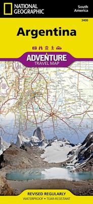
Wegenkaart - landkaart 3400 Adventure Map Argentina - Argentinië | National Geographic

0
Wegenkaart van Argentinië met vermelding van veel bezienswaardigheden, nationale parken en attrakties. Watervast en scheurvast. Juist door deze vermeldingen onderscheidt de kaart zich van andere wegenkaarten. National Geographic's Argentina Adventure Map is designed to meet the unique needs of adventure travelers—detailed, durable, and accurate. A...

Verkopers met dit product

Verkoper
Bezorging
Prijs
DeZwerver.nl logo
DeZwerver.nl
2,95
17,50

Anderen bekeken ook

Wegenkaart - landkaart 3402 Adventure Map Chile - Chili | National Geographic
Wegenkaart van Chili met vermelding van veel bezienswaardigheden, nationale parken en attrakties. Watervast en scheurvast. Juist door deze vermeldingen onderscheidt de kaart zich van andere wegenkaarten.   National Geographic's Chile Adventure Map is designed to meet the unique needs of adventure travelers—detailed, durable, and accurate. Chile includes the locations of thousands of major cities and towns with an index for easily locating them, plus a clearly marked road network complete with distances and designations for major highways, toll roads, limited access highways and more.   What sets National Geographic Adventure Maps apart from traditional road maps are the hundreds of points-of-interest that highlight the diverse, unique, and exotic destinations within Chile including National Parks and Preserves, World Heritage Sites, Archeological sites, ski areas, beaches, waterfalls, natural points of interest and important travel aids like airports, airstrips, rail lines, lighthouse…
17,50
Wegenkaart - landkaart 3102 Adventure Map Dominican Republic | National Geographic
Wegenkaart van Dominicaanse Republiek met vermelding van veel bezienswaardigheden, nationale parken en attrakties. Watervast en scheurvast. Juist door deze vermeldingen onderscheidt de kaart zich van andere wegenkaarten. The Dominican Republic is the second largest nation in the Caribbean, occupying two-thirds of the stunning island of Hispaniola. Visitors can try their hand at windsurfing or kiteboarding, observe humpback whales, go whitewater rafting, or lounge on one of the many sugar-white beaches. The Dominican Republic Adventure Map features Pico Duarte, the highest point in the Caribbean (10,417 feet), as well as detailed map insets of the metropolitan and colonial areas of the capital city, Santo Domingo.   Side one features a large-scale, easy-to-read topographic map of the entire country that includes points of interest and photos throughout.   Side two features information about the Samana Peninsula, Del Este National Park, Lake Enriquillo (at 144 feet below sea level, the …
17,50
Wegenkaart - landkaart 3305 Adventure Map Tuscany - Toscane | National Geographic
Wegenkaart van Toscane met vermelding van veel bezienswaardigheden, nationale parken en attrakties. Watervast en scheurvast. Juist door deze vermeldingen onderscheidt de kaart zich van andere wegenkaarten. National Geographic's Tuscany Adventure Map is designed to meet the unique needs of adventure travelers—detailed, durable, and accurate. Tuscany includes the locations of thousands of cities and towns with an index for easily locating them, plus a clearly marked road network complete with distances and designations for expressways, motorways, scenic routes, and more.   What sets National Geographic Adventure Maps apart from traditional road maps are the hundreds of points of interest that highlight the diverse and unique destinations within Tuscany. Archeological sites, menhirs and other sites of interest from monuments, palaces, and castles to churches, chapels, and monasteries are noted making this map indispensable for travelers seeking to explore the region’s rich history. Users…
17,50
Wegenkaart - landkaart 3303 Adventure Map Ireland - Ierland | National Geographic
Wegenkaart van Ierland met vermelding van veel bezienswaardigheden, nationale parken en attrakties. Watervast en scheurvast. Juist door deze vermeldingen onderscheidt de kaart zich van andere wegenkaarten. National Geographic's Ireland Adventure Map is designed to meet the unique needs of adventure travelers—detailed, durable, and accurate. Ireland includes the locations of thousands of major cities and towns with an index for easily locating them, plus a clearly marked road network complete with distances and designations for major highways, limited access highways and more.   What sets National Geographic Adventure Maps apart from traditional road maps are the hundreds of points-of-interest that highlight the diverse, unique, and exotic destinations within Ireland including national parks and preserves, World Heritage sites, castles, archeological sites, monuments, scenic viewpoints, beaches, natural points of interest, and important travel aids like airports, airstrips, rail lines,…
17,50
Wegenkaart - landkaart 3407 Adventure Map Uruguay - Paraguay | National Geographic
Wegenkaart van Uruguay en Paraguay  met vermelding van veel bezienswaardigheden, nationale parken en attrakties. Watervast en scheurvast. Juist door deze vermeldingen onderscheidt de kaart zich van andere wegenkaarten. Let National Geographic's Uruguay and Paraguay Adventure Map guide you as you explore the unique biodiversity, rich history and vibrant culture of these two South American countries. Quickly find your destination with the aid of a user-friendly index of cities and towns. Then plan your route using the mapped road network, complete with distances and designations for major and secondary roads, as well as tracks and unsurfaced roads for those seeking to travel off the beaten path. Other travel network features include airports, airfields, railroads, harbors and border crossings. In addition, hundreds of cultural, historical, ecological and recreational points of interest are pinpointed, such as UNESCO World Heritage Sites, protected areas, beaches, waterfalls, camping, an…
17,50
Wegenkaart - landkaart 3203 Adventure Map Morocco - Marokko | National Geographic
Wegenkaart van Marokko met vermelding van veel bezienswaardigheden, nationale parken en attrakties. Watervast en scheurvast. Juist door deze vermeldingen onderscheidt de kaart zich van andere wegenkaarten. National Geographic's Morocco Adventure Map is designed to meet the unique needs of adventure travelers—detailed, durable, and accurate. Morocco includes the locations of thousands of cities and towns with an index for easily locating them, plus a clearly marked road network complete with distances and designations for motorways, dual carriageways, major roadways, and more. Transportation within and beyond the country is made easier with the location of airports, airfields, railroads, ferry routes, river crossings, lighthouses, harbors, border crossings, and petrol stations. What sets National Geographic Adventure Maps apart from traditional road maps are the hundreds of points of interest that highlight the diverse, unique, and exotic destinations within Morocco. In addition to typ…
17,50
Wegenkaart - landkaart Argentinië - Argentina | Borch
Mooie, geplastificeerde kaart van het Argentinië. Deze kaart biedt een goed overzicht van het land met detailkaarten.   Our soft-laminated folded map of Argentina shows: Argentina 1:3 800 000, Isla Grande de Tierra del Fuego 1:1 900 000, Los Glaciares National Park 1:750 000, Mount Fitz Roy 1: 250 000, Greater Buenos Aires 1:650 000, Buenos Aires 1:18 000, Cordoba 1:14 000, Salta 1:16 000, Argentina administrative and time zones. Borch Maps are easy to fold, durable and water-repellent with a wipeable surface. Borch Maps show hotels, museums, monuments, markets, public transport, top sights and points of interest, useful statistics, conversion charts for temperatures, weights and measurements, climate charts showing temperatures, sunshine hours, precipitation and humidity, overview maps, time zones, and much more...   Enchanted by the sophisticated European flair of Buenos Aires, watching the world go by from a sidewalk café whilst taking a break from the buzzing nightlife, one could …
11,50
Wegenkaart - landkaart 3403 Adventure Map Ecuador & Galapagos | National Geographic
Wegenkaart van Galapagos en Ecuador met vermelding van veel bezienswaardigheden, nationale parken en attrakties. Watervast en scheurvast. Juist door deze vermeldingen onderscheidt de kaart zich van andere wegenkaarten. National Geographic's Ecuador and Galapagos Adventure Map is designed to meet the unique needs of adventure travelers—detailed, durable, and accurate. Ecuador and Galapagos includes the locations of thousands of towns and villages, plus a clearly marked road network complete with distances and designations for highways, roads and more.   What sets National Geographic Adventure Maps apart from traditional road maps are the hundreds of points of interest that highlight the diverse, unique, and exotic destinations within Ecuador and the Galapagos islands including national parks and reserves, World Heritage sites, archeological sites, churches, spas, and more.   The front side of the map shows the southern half of Ecuador including the provinces of Zamora, Chinchipe, Loja,…
17,50
Wegenkaart - landkaart 3315 Adventure Map Corsica | National Geographic
Wegenkaart van Corsica met vermelding van veel bezienswaardigheden, nationale parken en attrakties. Watervast en scheurvast. Juist door deze vermeldingen onderscheidt de kaart zich van andere wegenkaarten. National Geographic's Corsica Adventure Map is designed to meet the unique needs of adventure travelers with its durability and accurate information. Each folded map provides global travelers with the perfect combination of detail and perspective, highlighting the area’s terrain and best locations for adventure activities like snorkeling, surfing, fishing, and more. Adventure Maps include hundreds of points of interest that highlight diverse and unique destinations within the country.   The map includes the locations of thousands of cities and towns with a user-friendly index, plus a clearly marked road network complete with distances and designations for major highways, main roads, and tracks and trails for those seeking to explore more remote regions. The front side of the Corsica…
17,50
Wegenkaart - landkaart 3202 Adventure Map Egypt - Egypte | National Geographic
Wegenkaart van Egypte met vermelding van veel bezienswaardigheden, nationale parken en attrakties. Watervast en scheurvast. Juist door deze vermeldingen onderscheidt de kaart zich van andere wegenkaarten. National Geographic's Egypt Adventure Map is designed to meet the unique needs of adventure travelers with its detail, durability, and accuracy. The map includes the locations of thousands of cities and towns with an index for easily locating them, plus a clearly marked road network complete with distances and designations for expressways, major roadways, and more. Transportation within and beyond the country is made easier with the locations of airports, airfields, railroads, ferry routes, lighthouses, harbors, border crossings, and police control points.   What sets National Geographic Adventure Maps apart from traditional road maps are the hundreds of points of interest that highlight the diverse, unique, and exotic destinations within Egypt. In addition to typical sites of intere…
17,50

Klanten-reviews van Wegenkaart - landkaart 3400 Adventure Map Argentina - Argentinië | National Geographic

Er zijn nog geen beoordelingen voor dit productBen jij de eerste die een review plaatst?

Meer over Wegenkaart - landkaart 3400 Adventure Map Argentina - Argentinië | National Geographic

Productomschrijving

Wegenkaart van Argentinië met vermelding van veel bezienswaardigheden, nationale parken en attrakties. Watervast en scheurvast. Juist door deze vermeldingen onderscheidt de kaart zich van andere wegenkaarten.

National Geographic's Argentina Adventure Map is designed to meet the unique needs of adventure travelers—detailed, durable, and accurate. Argentina includes the locations of thousands of major cities and towns with an index for easily locating them, plus a clearly marked road network complete with distances and designations for major highways, limited access highways, minor roads, and more.   What sets National Geographic Adventure Maps apart from traditional road maps are the hundreds of points-of-interest that highlight the diverse, unique, and exotic destinations within Argentina including national parks and preserves, World Heritage sites, archeological sites, churches of interest, scenic viewpoints, natural points of interest, and important travel aids like airports, airstrips, rail lines, lighthouses, and harbors.   The north side of the Argentina map details the most highly populated areas of the country including the provinces of Buenos Aires, Córdoba, and Santa Fe as well as the impressive landscape of the Cordillera de los Andes bordering Chile on the northwest. Vineyards in Mendoza, Argentina’s world-renowned wine producing province are included, as are ski areas in this popular tourist region. An inset map shows the small province of Misiones that juts into the neighboring countries of Brazil and Paraguay. The south side of the map details Argentina’s extensive coastline from Mar Del Plata to Tierra Del Fuego highlighting beaches, preserves, and areas noted for fishing and surfing.  


Popular places included on the map: Patagonia, Los Glaciares National Park, Península Valdés, Iguazú Falls, Andes Mountains, Puente del Inca, Quebrada de Humahuaca and The Pampas.

Productinformatie

    Verken gerelateerde categorieën

    Webshop.nl maakt gebruik van cookies. Ga je verder op onze website, ga dan akkoord met het plaatsen van cookies en de verwerking van deze data door ons en vermelde partners.