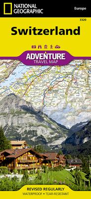
Wegenkaart - landkaart 3320 Adventure Map Switzerland - Zwitserland | National Geographic

0
Wegenkaart van Zwitserland met vermelding van veel bezienswaardigheden, nationale parken en attrakties. Watervast en scheurvast. Juist door deze vermeldingen onderscheidt de kaart zich van andere wegenkaarten. National Geographic's Switzerland AdventureMapis designed to meet the needs of adventure travelers with its durability and detailed, accura...

Verkopers met dit product

Verkoper
Bezorging
Prijs
DeZwerver.nl logo
DeZwerver.nl
2,95
17,50

Anderen bekeken ook

Wegenkaart - landkaart 3320 Adventure Map Switzerland - Zwitserland | National Geographic
Wegenkaart van Zwitserland met vermelding van veel bezienswaardigheden, nationale parken en attrakties. Watervast en scheurvast. Juist door deze vermeldingen onderscheidt de kaart zich van andere wegenkaarten. National Geographic's Switzerland AdventureMapis designed to meet the needs of adventure travelers with its durability and detailed, accurate information. The map includes the locations of cities and towns with a user-friendly index, a clearly marked road network complete with distances and designations for roads/highways, plus secondary routes for those seeking to explore off the beaten path.    AdventureMaps differ from a traditional road map because of the specialty content that they include. Each map contains hundreds of diverse and unique recreational, ecological, cultural and historic destinations - outside of the major tourist hubs. National Geographic AdventureMaps are the perfect companion to a guidebook, yet far easier to pack!    The Switzerland AdventureMap is printe…
17,50
Wegenkaart - landkaart Switzerland - Zwitserland | Marco Polo
Marco Polo Switzerland Map: the ideal map for your trip   Let the Marco Polo Switzerland Road Map guide you around the Switzerland. Discover quaint mountain villages, shimmering lakes, high peaks, stunning waterfalls and exquisite cities with this highly durable, detailed, touring map of Switzerland. It folds away easily and is always on standby to help when you're stuck. Perfect touring map - the scale is 1 : 275 000 ideal to help you tour the region by car or RV Easy to use - the superbly clear mapping in strong colors and easy to read text will help you navigate the country like a local   Durable, tear-resistant map - designed to withstand the rigors of the road, the map is printed on tear-resistant, water repellent and writeable paper Highlights included - major sights and key points of interest are marked on the map by numbered stars. Further information about these key sights can be downloaded via a QR code where you’ll find a brief description to help you pick the best places t…
14,95
Wegenkaart - landkaart 3326 Adventure Map Scotland - Schotland | National Geographic
Wegenkaart van Schotland met vermelding van veel bezienswaardigheden, nationale parken en attrakties. Watervast en scheurvast. Juist door deze vermeldingen onderscheidt de kaart zich van andere wegenkaarten. National Geographic's Scotland AdventureMapis designed to meet the needs of adventure travelers with its durability and detailed, accurate information. The map includes the locations of cities and towns with a user-friendly index, a clearly marked road network complete with distances and designations for roads/highways, plus secondary routes for those seeking to explore off the beaten path.    AdventureMaps differ from a traditional road map because of the specialty content that they include. Each map contains hundreds of diverse and unique recreational, ecological, cultural and historic destinations - outside of the major tourist hubs. National Geographic AdventureMaps are the perfect companion to a guidebook, yet far easier to pack!    The Scotland AdventureMap is printed in the…
17,50
Wegenkaart - landkaart 3319 Adventure Map Austria - Oostenrijk | National Geographic
Wegenkaart van Oostenrijk met vermelding van veel bezienswaardigheden, nationale parken en attrakties. Watervast en scheurvast. Juist door deze vermeldingen onderscheidt de kaart zich van andere wegenkaarten. National Geographic's Austria AdventureMapis designed to meet the needs of adventure travelers with its durability and detailed, accurate information. The map includes the locations of cities and towns with a user-friendly index, a clearly marked road network complete with distances and designations for roads/highways, plus secondary routes for those seeking to explore off the beaten path.    AdventureMaps differ from a traditional road map because of the specialty content that they include. Each map contains hundreds of diverse and unique recreational, ecological, cultural and historic destinations - outside of the major tourist hubs. National Geographic AdventureMaps are the perfect companion to a guidebook, yet far easier to pack!    The Austria AdventureMap is printed in the …
17,50
Reisgids Switzerland - Zwitserland | Rough Guides
Zeer goede reisgids voor zowel de georganiseerde maar vooral voor de zelfstandige reiziger. Boordevol informatie over reizen, slapen, eten, maar ook musea en cultuur. Voor Europese landen meestal completer en beter dan de Lonely Planet !  This item is eligible for FREE Click and Collect without a minimum order subject to availability. Details Practical travel guide to Switzerland with a free eBook points-of-interest structured lists of all sights and off-the-beaten-track treasures, with detailed colour-coded maps, practical details about what to see and to do in Switzerland, how to get there and around, pre-departure information, as well as top time-saving tips, like a visual list of things not to miss in Switzerland, expert author picks and itineraries to help you plan your trip.   The Rough Guide to Switzerland covers: Geneva, Lausanne and Lake Geneva, The Arc Jurassien, Basel and around, Bern and around, The Bernese Oberland, Valais, Lucerne and Central Switzerland, Zürich, Northea…
24,95
Reisgids Switzerland - Zwitserland | Lonely Planet
De perfecte reisgids voor zowel de georganiseerde als de zelfstandige reiziger. Naast een algemene inleiding van het land / streek vol met praktische informatie over hoe je er het beste kunt reizen: slapen, eten, vervoer, excursies ... alles kun je er in vinden. Engelstalig. Lonely Planet   Lonely Planet's local travel experts reveal all you need to know to plan the trip of a lifetime to Switzerland.   Discover popular and off the beaten track experiences from climbing Mt Rigi's panorama hiking trail for epic views to puffing up snow-dusted peaks aboard the Brienz Rothorn Bahn, and exploring the medieval Schloss Habsburg, the ancestral home to the Habsburg dynasty.   Build a trip to remember with Lonely Planet's Switzerland travel guide:   Our classic guidebook format provides you with the most comprehensive level of information for planning multi-week trips Updated with an all new structure and design so you can navigate Switzerland and connect experiences together with eas…
24,95
Wegenkaart - landkaart 3325 Adventure Map United Kingdom - Verenigd Koninkrijk - Engeland | National Geographic
Wegenkaart van het Verenigd Koninkrijk met vermelding van veel bezienswaardigheden, nationale parken en attrakties. Watervast en scheurvast. Juist door deze vermeldingen onderscheidt de kaart zich van andere wegenkaarten. National Geographic's United Kingdom AdventureMapis designed to meet the needs of adventure travelers with its durability and detailed, accurate information. The map includes the locations of cities and towns with a user-friendly index, a clearly marked road network complete with distances and designations for roads/highways, plus secondary routes for those seeking to explore off the beaten path.    AdventureMaps differ from a traditional road map because of the specialty content that they include. Each map contains hundreds of diverse and unique recreational, ecological, cultural and historic destinations - outside of the major tourist hubs. National Geographic AdventureMaps are the perfect companion to a guidebook, yet far easier to pack!    The Great Britain Adven…
17,50
Wegenkaart - landkaart 3112 Adventure Map Cuba | National Geographic
Wegenkaart van Cuba met vermelding van veel bezienswaardigheden en attrakties. Watervast en scheurvast. Juist door deze vermeldingen onderscheidt de kaart zich van andere wegenkaarten. National Geographic's Cuba AdventureMap is designed to meet the unique needs of adventure travelers with its durability and accurate information. Each folded map provides global travelers with the perfect combination of detail and perspective, highlighting the area s terrain and best locations for adventure activities like snorkeling, surfing, fishing, and more.    AdventureMaps include hundreds of points of interest that highlight diverse and unique destinations within the country. The map includes the locations of thousands of cities and towns with a user-friendly index, plus a clearly marked road network complete with distances and designations for major highways, main roads, and tracks and trails for those seeking to explore more remote regions.    AdventureMaps are printed in the United States on a…
17,50
Wegenkaart - landkaart 3016 Adventure Map Vietnam south - Zuid | National Geographic
Mooie, heldere kaart van het zuidelijk deel van Vietnam, gedrukt op scheurvast en watervast papier.   National Geographic's Vietnam, South AdventureMap is designed to meet the unique needs of adventure travelers with its durability and accurate information. Each folded map provides global travelers with the perfect combination of detail and perspective, highlighting the area s terrain and best locations for adventure activities like snorkeling, surfing, fishing, and more.    AdventureMaps include hundreds of points of interest that highlight diverse and unique destinations within the region. The map includes the locations of thousands of cities and towns with a user-friendly index, plus a clearly marked road network complete with distances and designations for major highways, main roads, and tracks and trails for those seeking to explore more remote regions.    The front side of the Vietnam South map details the lower central region of the country, from its border with Laos and Cambod…
17,50
Wegenkaart - landkaart 3015 Adventure Map Vietnam North - Noord | National Geographic
Mooie, heldere kaart van het zuidelijk deel van Vietnam, gedrukt op scheurvast en watervast papier. National Geographic's Vietnam, North AdventureMap is designed to meet the unique needs of adventure travelers with its durability and accurate information. Each folded map provides global travelers with the perfect combination of detail and perspective, highlighting the area s terrain and best locations for adventure activities like snorkeling, surfing, fishing, and more.    AdventureMaps include hundreds of points of interest that highlight diverse and unique destinations within the region. The map includes the locations of thousands of cities and towns with a user-friendly index, plus a clearly marked road network complete with distances and designations for major highways, main roads, and tracks and trails for those seeking to explore more remote regions.    The front side of the Vietnam North map details the north central region of the country, from its border with Laos to the w…
17,50

Klanten-reviews van Wegenkaart - landkaart 3320 Adventure Map Switzerland - Zwitserland | National Geographic

Er zijn nog geen beoordelingen voor dit productBen jij de eerste die een review plaatst?

Meer over Wegenkaart - landkaart 3320 Adventure Map Switzerland - Zwitserland | National Geographic

Productomschrijving

Wegenkaart van Zwitserland met vermelding van veel bezienswaardigheden, nationale parken en attrakties. Watervast en scheurvast. Juist door deze vermeldingen onderscheidt de kaart zich van andere wegenkaarten.

National Geographic's Switzerland AdventureMapis designed to meet the needs of adventure travelers with its durability and detailed, accurate information. The map includes the locations of cities and towns with a user-friendly index, a clearly marked road network complete with distances and designations for roads/highways, plus secondary routes for those seeking to explore off the beaten path.    AdventureMaps differ from a traditional road map because of the specialty content that they include. Each map contains hundreds of diverse and unique recreational, ecological, cultural and historic destinations - outside of the major tourist hubs. National Geographic AdventureMaps are the perfect companion to a guidebook, yet far easier to pack!    The Switzerland AdventureMap is printed in the United States on a durable synthetic paper, making it waterproof, tear-resistant, and capable of withstanding the rigors of international travel. The map is two-sided and is folded to a packable size of (4.25" x 9.25" ); unfolded size is (26" x 38"). Travel Tip! Due to the synthetic sheet that AdventureMaps are printed on, you can easily fold the map to a discreet size, showing just the area that you're interested in.   Key Features:
  • Waterproof and tear-resistant
  • Designed and printed in the U.S.A.
  • Detailed topography with clearly labeled natural features
  • Major road networks
  • Hundreds of points of interest, including the location of parks and protected lands
  • Thousands of place names with a detailed index
  • Important travel aids including airports, rail lines, and other infrastructure
  • Latitude/Longitude and UTM grids along with a compass rose and scale bars for accurate navigation with compass or GPS

Productinformatie

    Verken gerelateerde categorieën

    Webshop.nl maakt gebruik van cookies. Ga je verder op onze website, ga dan akkoord met het plaatsen van cookies en de verwerking van deze data door ons en vermelde partners.