Wegenkaart - landkaart 3308 Adventure Map Pyrenees & Andorra - Pyreneeën en Andorra | National Geographic

0
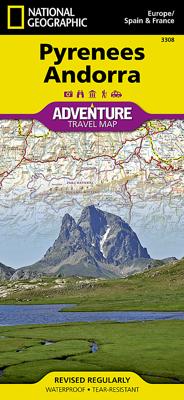
Wegenkaart van de Pyreneeën en Andorra met vermelding van veel bezienswaardigheden, nationale parken en attrakties. Watervast en scheurvast. Juist door deze vermeldingen onderscheidt de kaart zich van andere wegenkaarten. National Geographic's Pyrenees and Andorra Adventure Map is designed to meet the unique needs of adventure travelers—detailed, ...

Verkopers met dit product

Verkoper
Bezorging
Prijs
DeZwerver.nl logo
DeZwerver.nl
2,95
17,50

Anderen bekeken ook

Wegenkaart - landkaart 3308 Adventure Map Pyrenees & Andorra - Pyreneeën en Andorra | National Geographic
Wegenkaart van de Pyreneeën en Andorra met vermelding van veel bezienswaardigheden, nationale parken en attrakties. Watervast en scheurvast. Juist door deze vermeldingen onderscheidt de kaart zich van andere wegenkaarten. National Geographic's Pyrenees and Andorra Adventure Map is designed to meet the unique needs of adventure travelers—detailed, durable, and accurate. Pyrenees/Andorra includes the locations of thousands of major cities and towns with an index for easily locating them, plus a clearly marked road network complete with distances and designations for expressways, motorways, scenic routes, and more.   What sets National Geographic AdventureMaps apart from traditional road maps are the hundreds of points of interest that highlight the diverse and unique destinations within the Pyrenees and Andorra. National parks, World Heritage sites, scenic viewpoints, antiquity sites, museums, places of worship, zoos, castles and more are included, making it invaluable to travelers hopi…
17,50
Wegenkaart - landkaart 146 Pyrénées orientales - Andorre - Spaanse Pyreneeën oost en Andorra | Michelin
Speciale serie van Michelin met de naam ZOOM. Deze kaarten bedekken een deel van Spanje op behoorlijk gedetailleerd nivo. Er zijn nauwelijks andere kaarten die deze mate van detail halen. Voor toeristische hoogtepunten en vele andere zaken worden symbolen gebruikt die voor zich speken. Er is een legenda en van de streek zijn van de belangrijkste steden een kleine maar bruikbare plattegrond bijgevoegd. Vanwege de schaal - 1:150.000 - is deze kaart niet alleen voor de auto maar zeker ook voor de fiets zeer geschikt. Helaas dekt de serie niet het hele land. Pic d'Estats , Andorre , Occitanie, Perpignan, Pyrénées-Orientales
10,95
Wandelgids Centrale en Oostelijke Pyreneeën deel 1 Catalonië en Andorra | Uitgeverij Elmar
Goede wandelgids met 24 dagwandelingen in het specifieke gebied. De routes zijn uitstekend en gedetailleerd beschreven, voorzien van praktische informatie en een schetsmatige kaart. Je zou het met de beschrijving kunnen doen, maar in berggebied is het zonder meer raadzaam om een goede kaart bij je te hebben. De schrijver maakt steeds melding welke kaart bij welke route(s) past.    De Pyreneeën zijn een uitgelezen gebied voor wandelaars die willen genieten van een onbedorven bergwereld met zijn rijke flora en fauna en gevarieerde landschappen. Geen enkele streek is hetzelfde, elke vallei is anders. In de Pyreneeën blijf je wandelen en raak je nooit uitgekeken!   De wandelingen in dit deel betreffen Catalunya (Spanje) en Andorra.   Pyreneeënspecialist Ton Joosten selecteerde het beste van het beste. Maar de gids bevat meer dan een opsomming van wandelroutes. Tevens wordt uitgebreide informatie verstrekt over bezienswaardigheden, standplaatsen, herbergen, berghutten en campings, met inte…
18,99
Wandelkaart Trekking map Central Pyrenees - Pyreneeën | TerraQuest
Uitstekende wandelkaart van een deel van de Pyreneën. Alle noodzakelijke gegevens staan er op, de kaart is gebaseerd op topografische kaarten en voorzien van ingetekende wandelroutes. De kaart is geplastificeerd. Voor een uitsnede welk gebied deze kaart dekt. This is the 1:50,000 trekking map for the Central Pyrenees covering Lourdes, Trebons and Capvern on the north edge of the map and down to Monte Perdido in the south.   Terraquest say 'TerraQuest maps are designed and developed primarily for tourists preparing for treks to remote corners of the world. Our proven map laminating technology allows you to freely use the maps even in harsh conditions, while appreciating the clear and easy-to-read information compiled by our team of qualified cartographers. The distinctive feature of terraQuest laminated maps is the manufacturing method. Due to a special lamination process and patented map joining techniques, the maps easily adjust to your choice of format , even for one-hand use only. …
18,50
Wandelgids The Pyrenees - Pyreneeen | Cicerone
Uitputtende beschrijving van alle wandel- en klimmogelijkheden in de Pyreneeen. Ongekende diepgang in informatie over wat, waar en hoe de gebieden in elkaar zitten. Geschreven door een van de toonaangevende bergwandelaars op dit moment: Kev Reynolds. Essential guidebook of walks and climbs in the Pyrenees, one of Europe's finest mountain ranges. The guide includes 170 day walks, multi-day walks, climbing routes and mountaineering ascents, and covers all valleys and peaks on both sides of the border with France and Spain, with through routes and peaks to bag.   The guidebook divides the range into 21 sections, including Andorra, the Ordesa National Park, the Carlit Massif, Gavarnie and the Cirque du Lescun to name a few. Each area includes practical information on travel, accommodation and mountain refuges, as well sketch mapping.   Between short, half-hour walks, to 12-day treks and 25 summits, this guidebook will help any walker, climber or trekker experience the best of the Pyr…
24,95
Wegenkaart - landkaart 3307 Adventure Map Spain & Portugal - Spanje en Portugal | National Geographic
Wegenkaart van Spanje en Portugal met vermelding van veel bezienswaardigheden, nationale parken en attracties. Watervast en scheurvast. Juist door deze vermeldingen onderscheidt de kaart zich van andere wegenkaarten.   National Geographic's Spain and Portugal Adventure Map is designed to meet the unique needs of adventure travelers—detailed, durable, and accurate. Spain/Portugal includes the locations of thousands of major cities and towns with an index for easily locating them, plus a clearly marked road network complete with distances and designations for expressways, motorways, and more.   What sets National Geographic Adventure Maps apart from traditional road maps are the hundreds of points of interest that highlight the diverse and unique destinations within Spain/Portugal. National parks, World Heritage sites, caves, scenic viewpoints, archeological sites, museums, castles, churches, monasteries, and ruins are included, making it invaluable to travelers hoping to experience all…
17,50
Wegenkaart - landkaart 3314 Adventure Map Southern France - Zuid Frankrijk | National Geographic
Wegenkaart van Frankrijk Zuid met vermelding van veel bezienswaardigheden, nationale parken en attrakties. Watervast en scheurvast. Juist door deze vermeldingen onderscheidt de kaart zich van andere wegenkaarten. National Geographic's Southern France Adventure Map is designed to meet the unique needs of adventure travelers with its durability and accurate information. Each folded map provides global travelers with the perfect combination of detail and perspective, highlighting the area’s terrain and best locations for adventure activities like snorkeling, surfing, fishing, and more. Adventure Maps include hundreds of points of interest that highlight diverse and unique destinations within the region. The map includes the locations of thousands of cities and towns with a user-friendly index, plus a clearly marked road network complete with distances and designations for major highways, main roads, and tracks and trails for those seeking to explore more remote regions.   The front side …
17,50
Wegenkaart - landkaart 3007 Adventure Map China | National Geographic
Wegenkaart van China met vermelding van veel bezienswaardigheden, nationale parken en attrakties. Watervast en scheurvast.   National Geographic's China Adventure Map is designed to meet the unique needs of adventure travelers with its durability and detailed, accurate information. The map includes the locations of thousands of cities and towns with a user-friendly index, plus a clearly marked road network complete with distances and designations for major highways, major routes and secondary roads.   The China Adventure Map differs from a traditional road map because it includes hundreds of points of interest that highlight diverse and unique destinations in the region. UNESCO World Heritage sites, national parks and reserves, archaeological sites, temples, caves and points of interest such as the Great Wall of China are included, making it an invaluable resource to travelers hoping to experience all the history and culture China has to offer. Additional travel aids include the locat…
17,50
Wegenkaart - landkaart 3306 Adventure Map Spain Northern - Noord Spanje | National Geographic
Wegenkaart van Noord Spanje met vermelding van veel bezienswaardigheden, nationale parken en attrakties. Watervast en scheurvast. Juist door deze vermeldingen onderscheidt de kaart zich van andere wegenkaarten. National Geographic's Northern Spain Adventure Map is designed to meet the unique needs of adventure travelers—detailed, durable, and accurate. Northern Spain includes the locations of thousands of major cities and towns with an index for easily locating them, plus a clearly marked road network complete with distances and designations for expressways, motorways, and more. St. James Way, one of the most important Christian pilgrimages during medieval times, is noted for travelers seeking to retrace to route to the Cathedral of Santiago de Compostela in Galicia where the remains of the apostle Saint James are believed to be buried.   What sets National Geographic Adventure Maps apart from traditional road maps are the hundreds of points of interest that highlight the diverse and …
17,50

Klanten-reviews van Wegenkaart - landkaart 3308 Adventure Map Pyrenees & Andorra - Pyreneeën en Andorra | National Geographic

Er zijn nog geen beoordelingen voor dit productBen jij de eerste die een review plaatst?

Meer over Wegenkaart - landkaart 3308 Adventure Map Pyrenees & Andorra - Pyreneeën en Andorra | National Geographic

Productomschrijving

Wegenkaart van de Pyreneeën en Andorra met vermelding van veel bezienswaardigheden, nationale parken en attrakties. Watervast en scheurvast. Juist door deze vermeldingen onderscheidt de kaart zich van andere wegenkaarten.

National Geographic's Pyrenees and Andorra Adventure Map is designed to meet the unique needs of adventure travelers—detailed, durable, and accurate. Pyrenees/Andorra includes the locations of thousands of major cities and towns with an index for easily locating them, plus a clearly marked road network complete with distances and designations for expressways, motorways, scenic routes, and more.   What sets National Geographic AdventureMaps apart from traditional road maps are the hundreds of points of interest that highlight the diverse and unique destinations within the Pyrenees and Andorra. National parks, World Heritage sites, scenic viewpoints, antiquity sites, museums, places of worship, zoos, castles and more are included, making it invaluable to travelers hoping to experience all the history, art, and culture the region has to offer. Beaches and yachting harbors dot Spain and France’s Mediterranean coastlines while the location of golf courses, camping sites, waterfalls, caves, and ski areas make it easy to enjoy the region’s abundant outdoor activities. Users will find a variety of helpful travel aids on our map as well, including the location of airports, airfields, railroads, lighthouses, and petrol stations.  


The front side of the Pyrenees/Andorra map shows the country of Andorra and the eastern half of the Pyrenees including the cities of Narbonne, Carcassone, Pamiers, St-Gaudens, St-Girons, Perpignan in France, and Balaguer, Manresa, and Figueres in Spain. The reverse side of the map stretches from the city of Biarritz on the Bay of Biscay eastward to include Pamplona and Huesca, Spain, and Pau, Tarbes, and the famed pilgrimage site of Lourdes, France.

Productinformatie

    Verken gerelateerde categorieën

    Webshop.nl maakt gebruik van cookies. Ga je verder op onze website, ga dan akkoord met het plaatsen van cookies en de verwerking van deze data door ons en vermelde partners.