webshop.nl
Categorieën
  Sluiten

Meer National Geographic
Meer National Geographic in Literatuur boeken

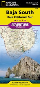
Wegenkaart - landkaart 3104 Adventure Map Baja California South - Baja

0
Wegenkaart van Baja California Zuid met vermelding van veel bezienswaardigheden, nationale parken en attrakties. Watervast en scheurvast. Juist door deze vermeldingen onderscheidt de kaart zich van andere wegenkaarten. National Geographic’s Baja South Adventure Map combines detailed terrain with local information on the entire State of Baja Califor...

Webshops met dit product

Webshop
Bezorging
Prijs

Anderen bekeken ook

Wegenkaart - landkaart 3104 Adventure Map Baja California South - Baja
Wegenkaart van Baja California Zuid met vermelding van veel bezienswaardigheden, nationale parken en attrakties. Watervast en scheurvast. Juist door deze vermeldingen onderscheidt de kaart zich van andere wegenkaarten. National Geographic’s Baja South Adventure Map combines detailed terrain with local information on the entire State of Baja California Sur. Together with the Baja North Adventure Map, it covers the entire Baja peninsula and includes detailed insets of Tijuana, Mexicali, Ensenada, La Paz, San Jose Del Cabo, Cabo San Lucas, and the Cabo Resort Corridor. Coverage Highlights: Federally Protected Areas, including parks and reserves, provided by the Nature Conservancy of Mexico; detailed road network, ferry routes, and mileage charts; UNESCO World Heritage Sites; historic mission locations; popular diving, surfing, fishing, snorkeling, whale watching, and scenic viewpoint locations; detailed terrain with shaded relief; useful travel information.
17,50
Wegenkaart - landkaart 3103 Adventure Map Baja California North - Baja
Wegenkaart van Baja Californië Noord met vermelding van veel bezienswaardigheden, nationale parken en attrakties. Watervast en scheurvast. Juist door deze vermeldingen onderscheidt de kaart zich van andere wegenkaarten. National Geographic’s Baja North Adventure Map combines detailed terrain with local information on the entire State of Baja California. Together with the Baja South Adventure Map, it covers the entire Baja peninsula and includes detailed insets of Tijuana, Mexicali, Ensenada, La Paz, San Jose Del Cabo, Cabo San Lucas, and the Cabo Resort Corridor. Coverage Highlights: Federally Protected Areas, including parks and reserves, provided by the Nature Conservancy of Mexico; detailed road network, ferry routes, and mileage charts; UNESCO World Heritage Sites; historic mission locations; popular diving, surfing, fishing, snorkeling, whale watching, and scenic viewpoint locations; detailed terrain with shaded relief; useful travel information
17,50
Wegenkaart - landkaart 3315 Adventure Map Corsica | National Geographi
Wegenkaart van Corsica met vermelding van veel bezienswaardigheden, nationale parken en attrakties. Watervast en scheurvast. Juist door deze vermeldingen onderscheidt de kaart zich van andere wegenkaarten. National Geographic's Corsica Adventure Map is designed to meet the unique needs of adventure travelers with its durability and accurate information. Each folded map provides global travelers with the perfect combination of detail and perspective, highlighting the area’s terrain and best locations for adventure activities like snorkeling, surfing, fishing, and more. Adventure Maps include hundreds of points of interest that highlight diverse and unique destinations within the country.   The map includes the locations of thousands of cities and towns with a user-friendly index, plus a clearly marked road network complete with distances and designations for major highways, main roads, and tracks and trails for those seeking to explore more remote regions. The front side of the Corsica …
17,50
Wegenkaart - landkaart 3313 Adventure Map France - Frankrijk | Nationa
Wegenkaart van Frankrijk met vermelding van veel bezienswaardigheden, nationale parken en attrakties. Watervast en scheurvast. Juist door deze vermeldingen onderscheidt de kaart zich van andere wegenkaarten. National Geographic's France Adventure Map is designed to meet the unique needs of adventure travelers with its durability and accurate information. Each folded map provides global travelers with the perfect combination of detail and perspective, highlighting the area’s terrain and best locations for adventure activities like snorkeling, surfing, fishing, and more. Adventure Maps include hundreds of points of interest that highlight diverse and unique destinations within the country. The map includes the locations of thousands of cities and towns with a user-friendly index, plus a clearly marked road network complete with distances and designations for major highways, main roads, and tracks and trails for those seeking to explore more remote regions. Adventure Maps are printed in t…
17,50
Wegenkaart - landkaart 3312 Adventure Map Germany - Duitsland | Nation
Wegenkaart van Duitsland met vermelding van veel bezienswaardigheden, nationale parken en attrakties. Watervast en scheurvast. Juist door deze vermeldingen onderscheidt de kaart zich van andere wegenkaarten. National Geographic's Germany Adventure Map is designed to meet the unique needs of adventure travelers with its durability and accurate information. Each folded map provides global travelers with the perfect combination of detail and perspective, highlighting the area’s terrain and best locations for adventure activities like snorkeling, surfing, fishing, and more. Adventure Maps include hundreds of points of interest that highlight diverse and unique destinations within the country.   The map includes the locations of thousands of cities and towns with a user-friendly index, plus a clearly marked road network complete with distances and designations for major highways, main roads, and tracks and trails for those seeking to explore more remote regions. The front side of the German…
17,50
Wegenkaart - landkaart 3314 Adventure Map Southern France - Zuid Frank
Wegenkaart van Frankrijk Zuid met vermelding van veel bezienswaardigheden, nationale parken en attrakties. Watervast en scheurvast. Juist door deze vermeldingen onderscheidt de kaart zich van andere wegenkaarten. National Geographic's Southern France Adventure Map is designed to meet the unique needs of adventure travelers with its durability and accurate information. Each folded map provides global travelers with the perfect combination of detail and perspective, highlighting the area’s terrain and best locations for adventure activities like snorkeling, surfing, fishing, and more. Adventure Maps include hundreds of points of interest that highlight diverse and unique destinations within the region. The map includes the locations of thousands of cities and towns with a user-friendly index, plus a clearly marked road network complete with distances and designations for major highways, main roads, and tracks and trails for those seeking to explore more remote regions.   The front side o…
17,50

Klanten-reviews van Wegenkaart - landkaart 3104 Adventure Map Baja California South - Baja

Er zijn nog geen beoordelingen voor dit productBen jij de eerste die een review plaatst?

Meer over Wegenkaart - landkaart 3104 Adventure Map Baja California South - Baja

Productomschrijving

Wegenkaart van Baja California Zuid met vermelding van veel bezienswaardigheden, nationale parken en attrakties. Watervast en scheurvast. Juist door deze vermeldingen onderscheidt de kaart zich van andere wegenkaarten. National Geographic’s Baja South Adventure Map combines detailed terrain with local information on the entire State of Baja California Sur. Together with the Baja North Adventure Map, it covers the entire Baja peninsula and includes detailed insets of Tijuana, Mexicali, Ensenada, La Paz, San Jose Del Cabo, Cabo San Lucas, and the Cabo Resort Corridor. Coverage Highlights: Federally Protected Areas, including parks and reserves, provided by the Nature Conservancy of Mexico; detailed road network, ferry routes, and mileage charts; UNESCO World Heritage Sites; historic mission locations; popular diving, surfing, fishing, snorkeling, whale watching, and scenic viewpoint locations; detailed terrain with shaded relief; useful travel information.

Productspecificaties

Artikelnummer(s)
Brand
National Geographic

Verken gerelateerde categorieën

Webshop.nl maakt gebruik van cookies. Ga je verder op onze website, ga dan akkoord met het plaatsen van cookies en de verwerking van deze data door ons en vermelde partners.