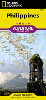
Wegenkaart - landkaart 3022 Adventure Map Philippines - Filipijnen | National Geographic

0
Wegenkaart van de Filipijnen met vermelding van veel bezienswaardigheden, nationale parken en attrakties. Watervast en scheurvast.   National Geographic's Philippines Adventure Map is designed to meet the unique needs of adventure travelers with its durability and accurate information. Each folded map provides global travelers with the perfect com...

Verkopers met dit product

Verkoper
Bezorging
Prijs
DeZwerver.nl logo
DeZwerver.nl
2,95
17,50

Anderen bekeken ook

Wegenkaart - landkaart 3022 Adventure Map Philippines - Filipijnen | National Geographic
Wegenkaart van de Filipijnen met vermelding van veel bezienswaardigheden, nationale parken en attrakties. Watervast en scheurvast.   National Geographic's Philippines Adventure Map is designed to meet the unique needs of adventure travelers with its durability and accurate information. Each folded map provides global travelers with the perfect combination of detail and perspective, highlighting the area’s terrain and best locations for adventure activities like snorkeling, surfing, fishing, and more. Adventure Maps include hundreds of points of interest that highlight diverse and unique destinations within the country.   The map includes the locations of thousands of cities and towns with a user-friendly index, plus a clearly marked road network complete with distances and designations for major highways, main roads, and tracks and trails for those seeking to explore more remote regions.   Key Features: Waterproof and tear-resistant Detailed interpretive information and local travel…
17,50
Wegenkaart - landkaart Philippines - Filipijnen | ITMB
Een degelijke kaart met aanduidingen van o.a. nationale parken, vliegveld, benzinepomp, dirt-roads en kleine plattegrond van hoofdstad. Als overzichtskaart goed te gebruiken. Inclusief plattegrond van Manilla 1:12000 This is an excellent map of the Philippines; newly updated. There are improvements on road classification a re-working of the Manila inset. double-sided. Legend Includes: Roads by classification, Point of Interest, National Park, Museum, Church, Cave, Beach, Dive Site, Golf Course, Airports and more.
13,95
Reisgids Philippines - Filipijnen | Insight Guides
Dé gids als het gaat om achtergrondinformatie en prachtige foto’s. Door het formaat en gewicht wellicht niet zo zeer om mee te nemen, als wel om thuis voor en na de reis uitgebreid te lezen. Kwalitatief van een hoog niveau! Engels Insight Guide Philippines is a comprehensive, full-colour travel guide that provides an essential introduction to this little-known Asian country. The Philippines is a destination of thousands of islands fringed by idyllic tropical beaches, plus stunning mountain scenery, colonial architecture and lively festivals. The Insight Guide will assist you in finding your ideal itinerary through what can be a daunting list of options, with the inspirational Best Of section setting out the principal places to visit in the Philippines. In-depth information on the country's history and culture is provided in a series of lively pages, while chapters on contemporary culture, food, festivals and architecture paint a vivid portrait of life in the Philippines today. The …
25,95
Reisgids Philippines - Filipijnen | Rough Guides
Zeer goede reisgids voor zowel de georganiseerde maar vooral voor de zelfstandige reiziger. Boordevol informatie over reizen, slapen, eten, maar ook musea en cultuur. Uitputtende bron van informatie, veelal nog completer dan de Lonely Planet. Inleidende informatie over land en cultuur is zeer goed. This practical travel guide to the Philippines features detailed factual travel tips and points-of-interest structured lists of all iconic must-see sights as well as some off-the-beaten-track treasures. Our itinerary suggestions and expert author picks of things to see and do will make it a perfect companion both, ahead of your trip and on the ground. This Philippines guide book is packed full of details on how to get there and around, pre-departure information and top time-saving tips, including a visual list of things not to miss.   Our colour-coded maps make the Philippines easier to navigate while you're there. This guide book to the Philippines has been fully updated post-COVID-19 and …
26,50
Wegenkaart - landkaart Philippines - Filipijnen | Reise Know-How Verlag
Tweetalige kaart (Engels en Duits). Door ingetekende lengte- en breedtegraden is het gebruik van GPS mogelijk. Met hoogtelijnen en uitgebreid wegennetwerk: daarnaast worden ook de afstanden tussen belangrijke plaatsen duidelijk leesbaar weergegeven. Het kleurgebruik is zodanig dat je een goede indruk krijgt van hoogteverschillen en soorten landschap. Natuurlijk staan de toeristische bezienswaardigheden duidelijk vermeld.   Gedrukt op water- en scheurvast papier! Polyart is een synthetisch product vrij van giftige stoffen dus duurzaam. Het papier gaat echt lang mee.   Topography is indicated by altitude colouring with numerous spot heights and names of mountain ranges and passes. Salt lakes, swamps, seasonal rivers and glacier are also shown. Detailed presentation of the road network includes minor roads and tracks and railways are also shown.   Internal administrative units are presented with their boundaries and names. National parks and other protected areas are highlighted. A wide …
15,95
Wegenkaart - landkaart 3023 Adventure Map Japan | National Geographic
Wegenkaart van Japan met vermelding van veel bezienswaardigheden, nationale parken en attrakties. Watervast en scheurvast. National Geographic's Japan Adventure Map is designed to meet the unique needs of adventure travelers with its durability and accurate information. Each folded map provides global travelers with the perfect combination of detail and perspective, highlighting the area’s terrain and best locations for adventure activities like snorkeling, surfing, fishing, and more. Adventure Maps include hundreds of points of interest that highlight diverse and unique destinations within the country.   The map includes the locations of thousands of cities and towns with a user-friendly index, plus a clearly marked road network complete with distances and designations for major highways, main roads, and tracks and trails for those seeking to explore more remote regions.   Key Features: Waterproof and tear-resistant Detailed interpretive information and local travel tips Detailed …
17,50
Wegenkaart - landkaart 3020 Adventure Map Java | National Geographic
Wegenkaart van Java met vermelding van veel bezienswaardigheden, nationale parken en attrakties. Watervast en scheurvast. National Geographic's Java Adventure Map is designed to meet the unique needs of adventure travelers to this Indonesian island with its durability and accurate information. Each folded map provides global travelers with the perfect combination of detail and perspective, highlighting the area’s terrain and best locations for adventure activities like snorkeling, surfing, fishing, and more. Adventure Maps include hundreds of points of interest that highlight diverse and unique destinations within the country.   The map includes the locations of thousands of cities and towns with a user-friendly index, plus a clearly marked road network complete with distances and designations for major highways, main roads, and tracks and trails for those seeking to explore more remote regions.   Key Features: Waterproof and tear-resistant Detailed interpretive information and loca…
17,50
Wegenkaart - landkaart 3406 Adventure Map Bolivia | National Geographic
Wegenkaart van Bolivia met vermelding van veel bezienswaardigheden, nationale parken en attrakties. Watervast en scheurvast. Juist door deze vermeldingen onderscheidt de kaart zich van andere wegenkaarten. National Geographic's Bolivia Adventure Map is designed to meet the unique needs of adventure travelers with its durability and accurate information. Each folded map provides global travelers with the perfect combination of detail and perspective, highlighting the area’s terrain and best locations for adventure activities like snorkeling, surfing, fishing, and more. Adventure Maps include hundreds of points of interest that highlight diverse and unique destinations within the country.   The map includes the locations of thousands of cities and towns with a user-friendly index, plus a clearly marked road network complete with distances and designations for major highways, main roads, and tracks and trails for those seeking to explore more remote regions.   Key Features: Waterproof a…
17,50
Wegenkaart - landkaart 3405 Adventure Map Colombia | National Geographic
Wegenkaart van Colombia met vermelding van veel bezienswaardigheden, nationale parken en attrakties. Watervast en scheurvast. Juist door deze vermeldingen onderscheidt de kaart zich van andere wegenkaarten.   National Geographic's Colombia Adventure Map is designed to meet the unique needs of adventure travelers with its durability and accurate information. Each folded map provides global travelers with the perfect combination of detail and perspective, highlighting the area’s terrain and best locations for adventure activities like snorkeling, surfing, fishing, and more. Adventure Maps include hundreds of points of interest that highlight diverse and unique destinations within the country.   The map includes the locations of thousands of cities and towns with a user-friendly index, plus a clearly marked road network complete with distances and designations for major highways, main roads, and tracks and trails for those seeking to explore more remote regions.   Key Features: Waterpro…
17,50
Reisgids Philippines - Filipijnen | Lonely Planet
De perfecte reisgids voor zowel de georganiseerde als de zelfstandige reiziger. Naast een algemene inleiding van het land / streek vol met praktische informatie over hoe je er het beste kunt reizen: slapen, eten, vervoer, excursies ... alles kun je er in vinden. Engelstalig. Lonely Planet Lonely Planet’s Philippines is your passport to the most relevant, up-to-date advice on what to see and skip, and what hidden discoveries await you. Cruise past the secluded beaches, pristine lagoons and rocky islets of the Bacuit Archipelago, join the adrenaline junkies wakeboarding, surfing, climbing and snorkelling on the Bicol peninsula, and choose which stretch of pearly white sand on which to escape the crowds; all with your trusted travel companion. Get to the heart of the Philippines and begin your journey now!     Inside Lonely Planet’s Philippines Travel Guide:   Up-to-date information - all businesses were rechecked before publication to ensure they are still open after 2020’s COVID…
25,95

Klanten-reviews van Wegenkaart - landkaart 3022 Adventure Map Philippines - Filipijnen | National Geographic

Er zijn nog geen beoordelingen voor dit productBen jij de eerste die een review plaatst?

Meer over Wegenkaart - landkaart 3022 Adventure Map Philippines - Filipijnen | National Geographic

Productomschrijving

Wegenkaart van de Filipijnen met vermelding van veel bezienswaardigheden, nationale parken en attrakties. Watervast en scheurvast.   National Geographic's Philippines Adventure Map is designed to meet the unique needs of adventure travelers with its durability and accurate information. Each folded map provides global travelers with the perfect combination of detail and perspective, highlighting the area’s terrain and best locations for adventure activities like snorkeling, surfing, fishing, and more. Adventure Maps include hundreds of points of interest that highlight diverse and unique destinations within the country.   The map includes the locations of thousands of cities and towns with a user-friendly index, plus a clearly marked road network complete with distances and designations for major highways, main roads, and tracks and trails for those seeking to explore more remote regions.   Key Features:
  • Waterproof and tear-resistant
  • Detailed interpretive information and local travel tips
  • Detailed topography complete with activity symbols, ideal for exploring the country
  • City overview maps
  • Hundreds of points of interest, including the location of World Heritage sites, national parks and nature reserves, aboriginal settlements and protected lands, mines, archeological sites, wildlife parks and more
  • Thousands of place names
  • Important travel aids including airports, lighthouses, ferry routes and rail lines
  • Developed in cooperation with local agencies
  • Updated regularly to ensure accuracy

Productinformatie

    Verken gerelateerde categorieën

    Webshop.nl maakt gebruik van cookies. Ga je verder op onze website, ga dan akkoord met het plaatsen van cookies en de verwerking van deze data door ons en vermelde partners.