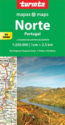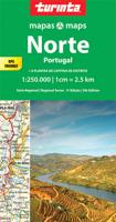
Wegenkaart - landkaart 1 Norte de Portugal - Noord Portugal | Turinta

0
Goede wegenkaart van een deel van Portugal. Op betere schaal dan de hele landenkaart, met meer details. Met register. This map covers the area from Vigo down to espinho, and from the Atlantic coast eastwards to the Spanish border. The map is geo-referenced & is compatible for use with a GPS. The map has colour shaded hills.    ...

Verkopers met dit product

Verkoper
Bezorging
Prijs
DeZwerver.nl logo
DeZwerver.nl
2,95
11,50

Anderen bekeken ook

Wegenkaart - landkaart Argentinië - Noord en Uruguay | Nelles Verlag
Goede kaart van het noorden van Argentinie met Uruguay. Aan beide kanten bedrukt. Met veel toeristische aanduidingen als nationale parken en culturele bezienswaardigheden. Prima leesbare kaart. Folded road and tourist map of Northern Argentina and Uruguay at 1:2 500 000 scale. All of Uruguay is covered and Argentina is covered from the northern border south past Bahia Blanca on the eastern coast. Places of interest and national parks are highlighted and shaded-relief colouring clearly depicts topography.    The map includes insets showing central Montevideo at 1:12 500, Tucuman at 1:30 000, Cordoba at 1:16 000, Iguacu at 1:450 000, central Buenos Aires at 1:20 000, greater Buenos Aires at 1:750 000 and a locator map. The legend is in English, German, Spanish and French.   For over 20 years Nelles maps have been renowned throughout the world for their quality, faithfulness to detail and up-to-dateness.    So that streets, ferry links, railway lines, etc are always up to date, Nelles ar…
11,95
Wegenkaart - landkaart 3203 Adventure Map Morocco - Marokko | National Geographic
Wegenkaart van Marokko met vermelding van veel bezienswaardigheden, nationale parken en attrakties. Watervast en scheurvast. Juist door deze vermeldingen onderscheidt de kaart zich van andere wegenkaarten. National Geographic's Morocco Adventure Map is designed to meet the unique needs of adventure travelers—detailed, durable, and accurate. Morocco includes the locations of thousands of cities and towns with an index for easily locating them, plus a clearly marked road network complete with distances and designations for motorways, dual carriageways, major roadways, and more. Transportation within and beyond the country is made easier with the location of airports, airfields, railroads, ferry routes, river crossings, lighthouses, harbors, border crossings, and petrol stations. What sets National Geographic Adventure Maps apart from traditional road maps are the hundreds of points of interest that highlight the diverse, unique, and exotic destinations within Morocco. In addition to typ…
17,50
Wegenkaart - landkaart Garden Route | Zuid Afrika | Slingsby Maps
Brand new 11th edition of the FIRST and still the BEST Garden Route map … Now thoroughly updated. From Witsand and Heidelberg in the west, this ALL-NEW map has been extended eastwards through Mossel Bay, George, Knysna and Plett to include JEFFERYS BAY and the GAMTOOS RIVER MOUTH – with fully updated Tourism info AND a greatly improved scale!   The Garden Route is so much more than a scenic national road. Explore the intriguing winding side roads and you’ll discover places with names like Whiskey Creek, De Vlugt, Phantom Pass and Noetzie. In these lit- tle known by ways, you can find old goldmines, traces of elephants, magical forest walks, castles on beaches and old passes.   Water and tear resistant in plastic sleeve.   Features:   This is a relief-shaded double-sided map covering the whole of the Western Cape’s official Garden Route Tourism Region, from Heidelberg in the west to Jeffery’s Bay in the east It includes the Tsitsikamma and Outeniqua Mountains and the Langkloof to …
29,50
Wegenkaart - landkaart 3306 Adventure Map Spain Northern - Noord Spanje | National Geographic
Wegenkaart van Noord Spanje met vermelding van veel bezienswaardigheden, nationale parken en attrakties. Watervast en scheurvast. Juist door deze vermeldingen onderscheidt de kaart zich van andere wegenkaarten. National Geographic's Northern Spain Adventure Map is designed to meet the unique needs of adventure travelers—detailed, durable, and accurate. Northern Spain includes the locations of thousands of major cities and towns with an index for easily locating them, plus a clearly marked road network complete with distances and designations for expressways, motorways, and more. St. James Way, one of the most important Christian pilgrimages during medieval times, is noted for travelers seeking to retrace to route to the Cathedral of Santiago de Compostela in Galicia where the remains of the apostle Saint James are believed to be buried.   What sets National Geographic Adventure Maps apart from traditional road maps are the hundreds of points of interest that highlight the diverse and …
17,50
Wegenkaart - landkaart Cordillera Cantabrica - Asturias y provincias limitrofes | Adrados Ediciones
Gedetailleerde wegenkaart an de Cordillera Cantabrica met hoogtelijnen, hoogte verschillen in kleur en schaduw en UTM coördinaten. Met plaatsnamen index! Cordillera Cantabrica on a detailed road map from the Oviedo based Adrados Ediciones, presenting this mountainous region with contours at 100m intervals, altitude coluring, relief shading and UTM coordinates. Since the publishers specialize in detailed hiking maps, including the best coverage of the Picos de Europa, the map includes an exceptionally large number of names of peaks, passes, etc. Symbols highlight best rock and ice climbing areas, huts and refuges, campsites, mountain rescue posts and information centres. Along the coast numerous beaches are named. Road network includes small country roads and tracks. Local railway lines are shown, although not very easy to see on the base map filled with so much information. The map has a 10km UTM grid. Map legend is in Spanish only. On the reverse is a panorama drawing of the area, lo…
14,95
Wegenkaart - landkaart - Fietskaart Donegal | Xploreit Maps
Zeer goed leesbare deelkaart van Ierland. Alle wegen, alle dorpen en steden en veel topografische details staan er op: daardoor zowel als wegenkaart ook als fietskaart goed te gebruiken. Naast de algemene kaartdetails zijn ook de bezienswaardigheden en historische monumenten goed ingetekend en makkelijk te vinden. Campings en jeugdherbergen maken het compleet.  This convenient and informative paper travel map is specifically designed for visitors to Donegal – the northernmost county in Ireland. With a heady mix of peninsulas, promontories and sandy beaches, Donegal’s  long, indented coastline includes some of the most spectacular scenery in the country. Further inland, the attractions are just as enticing and include Glenveagh National Park – an all-time favourite destination. This new map covers all of County Donegal and highlights local walking trails, cycle routes and scenic drives. The road network shown includes local roads and driving distances are indicated on the main routes. …
21,95
Wegenkaart - landkaart Thailand North - noord | ITMB
Een degelijke wegenkaart met aanduidingen van o.a. nationale parken, vliegveld, benzinepomp, dirt-roads. Als overzichtskaart goed te gebruiken.   The map actually goes from Bangkok north, and side one includes a very good inset map of Bangkok’s central area. Probably the most interesting spot on this side is the town of Kanchanaburi, which is within easy striking distance of Bangkok. This was the site made famous by the war movie Bridge on the River Kwai (now Khwae) on the Japanese-built Burma Railway. The current bridge is not the original, but the Commonwealth Graves Cemetery is well worth a visit. The other side concentrates on the wilder portion of Thailand, the far north. All known points of interest have been included, including a lovely inset map of Chiang Mai, the focal point of the north. The rail line ends here, but if the city’s many temples and pagodas don’t overwhelm you, tours to nearby temple sites abound. The temple complex near Phrae, further to the east, are also sho…
13,95
Wegenkaart - landkaart Nordkalotten - Lapland - Noord Scandinavie | Norstedts
Bijzonder prettig leesbare kaart van Lapland - Noord Scandinavie. Naast het wegennet staan bijvoorbeeld campings heel duidelijk aangegeven. Ook jeugdherbergen, vliegvelden en havens worden met symbolen ingetekend.  The map extends from Piteå in the south to Nordkap in the north. From Murmansk to the east to the Atlantic coast to the west.   Map legends in English, Norwegian, Finnish, German and French.   Within Norway, Sweden and Finland road network includes local roads, shows driving distances on main routes, and indicates sections closed during the winter months.
16,95
Wegenkaart - landkaart Portugal | Marco Polo
Duidelijke wegenkaart van Marco Polo: alle wegen, zowel de verharde als belangrijke onverharde wegen zijn weergegeven.  Mooie toeristisch interessante wegen die de moeite waard zijn, zijn groen gearceerd. Veel toeristische informatie is toegevoegd zoals de nationale parken, campings, kastelen en vliegvelden. Afstanden tussen belangrijke steden en benzinestations staan ook op de kaart. Een plaatsnamenregister ontbreekt niet.   ---   This Marco Polo map features really easy to read cartography. Topography is highlighted with relief shading and loads of spot heights and the road network is clearly shown with roads ranging from motorways all the way through to minor secondary roads. The map also clearly indicates airports, places of interest, scenic/tourist routes, view points etc.   The map includes a booklet attached to the cover that contains some useful information and a very extensive index that covers locations, places of interest and geographical features. Also included are a dista…
14,95

Klanten-reviews van Wegenkaart - landkaart 1 Norte de Portugal - Noord Portugal | Turinta

Er zijn nog geen beoordelingen voor dit productBen jij de eerste die een review plaatst?

Meer over Wegenkaart - landkaart 1 Norte de Portugal - Noord Portugal | Turinta

Productomschrijving

Goede wegenkaart van een deel van Portugal. Op betere schaal dan de hele landenkaart, met meer details. Met register.

This map covers the area from Vigo down to espinho, and from the Atlantic coast eastwards to the Spanish border. The map is geo-referenced & is compatible for use with a GPS. The map has colour shaded hills.


Verken gerelateerde categorieën

Webshop.nl maakt gebruik van cookies. Ga je verder op onze website, ga dan akkoord met het plaatsen van cookies en de verwerking van deze data door ons en vermelde partners.