webshop.nl
Categorieën
  Sluiten

Meer Hallwag
Meer Hallwag in Computeronderdelen

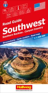
Wegenkaart - landkaart 06 Southwest, zuidwest USA - Utah, Colorado, Ar

Uitstekende wegenkaart waarbij de Europese kleurstelling de kaart zeer prettig leesbaar maken i.v.m. met Amerikaanse kaartenmakers. Deze kaart is eenzijdig bedrukt. Op de kaart is informatie te vinden waar allerlei voorzieningen te vinden zijn (d.m.v. symbolen), zoals campings, picknickplaatsen, informatiecentra, luchthavens enz. Bij de kaart zit e...
14,50

Webshops met dit product

Webshop
Bezorging
Prijs

Anderen bekeken ook

Wegenkaart - landkaart 06 Southwest, zuidwest USA - Utah, Colorado, Ar
Uitstekende wegenkaart waarbij de Europese kleurstelling de kaart zeer prettig leesbaar maken i.v.m. met Amerikaanse kaartenmakers. Deze kaart is eenzijdig bedrukt. Op de kaart is informatie te vinden waar allerlei voorzieningen te vinden zijn (d.m.v. symbolen), zoals campings, picknickplaatsen, informatiecentra, luchthavens enz. Bij de kaart zit een apart boekje met een aantal kleine stadsplattegronden, informatie over Nationale Parken en overige informatie voor toeristen.   Met Southern Rockies & Canyon Country (Utah, Colorado, Arizona & New Mexico)   These new, region by region "USA Road Guides", on a scale of 1 : 1 mio, provide up-to-date, detailed road maps with lots of tourist information. Transit and city maps, as well as detailed maps of national parks, are included in the map layout. The map package also includes a mileage chart with travelling times between major cities, and a brochure with an index of places, travel information from A to Z, top attractions and travel tips.  …
14,50
Wegenkaart - landkaart Utah & Colorado | ITMB
Een degelijke wegenkaart met aanduidingen van o.a. nationale parken, vliegveld, benzinepomp, dirt-roads. Als overzichtskaart goed te gebruiken. ITMB is gradually mapping the entire USA in appropriate scales. Most States fit fairly well into the 1:500 to 1:750T scale, and Utah is perfect for mapping. It is also a perfectly nice place to visit, so we are pleased to add it to our program. This map shares a sheet with Colorado, so please note that the ordering information is the same. Utah is Mormon country and the temple in Salt Lake City is a sight to see. The Great Salt Lake to its west is interesting to view, but more popular is the Bonneville Salt Flats at its western edge, where so many speed records have been won. Utah also has two of Americas most scenic national parks: Zion in the southwest and Canyonlands in the southeast. Combined with Colorado to its east and to Idaho in the north (ITMBs Pacific Northwest regional map) and ITMBs companion maps of Arizona and New Mexico, this ma…
13,95
Wegenkaart - landkaart 175 Four Corners USA | Michelin
Bijzonder goed leesbare kaart van een deel van de Verenigde Staten - USA, in dit geval het gebied van de staten Arizona - Utah - Colorado - New Mexico, ook wel de Four Corners genoemd.  Op deze kaart zijn de Nationale Parken goed zichtbaar ingetekend met een heldere achtergrondkleur. Wegnummers, register, afstanden tussen steden en bijvoorbeeld de beroemde groene wegenaanduiding van Michelin ontbreken niet.  Met stadsplattegronden (alleen het centrum)  van Albuquerque, Colorado Springs, Denver, Phoenix, Salt Lake City en Tucson. Michelin USA Four Corners Map 175 (scale: 1:1,267,000)—part of Michelin's brand-new US regional map series with bright green covers—zooms in close for comprehensive coverage of Arizona, Colorado, New Mexico and Utah. It contains city maps for easy driving in Albuquerque, Colorado Springs, Denver, Phoenix, Salt Lake City and Tucson. Michelin star-rated sights and a selection of not-to-be-missed annual events and festivals serve as inspiration for future road tri…
9,95
Wegenkaart - landkaart Utah & Colorado | ITMB
Een degelijke wegenkaart met aanduidingen van o.a. nationale parken, vliegveld, benzinepomp, dirt-roads. Als overzichtskaart goed te gebruiken. ITMB is gradually mapping the entire USA in appropriate scales. Most States fit fairly well into the 1:500 to 1:750T scale, and Utah is perfect for mapping. It is also a perfectly nice place to visit, so we are pleased to add it to our program. This map shares a sheet with Colorado, so please note that the ordering information is the same. Utah is Mormon country and the temple in Salt Lake City is a sight to see. The Great Salt Lake to its west is interesting to view, but more popular is the Bonneville Salt Flats at its western edge, where so many speed records have been won. Utah also has two of Americas most scenic national parks: Zion in the southwest and Canyonlands in the southeast. Combined with Colorado to its east and to Idaho in the north (ITMBs Pacific Northwest regional map) and ITMBs companion maps of Arizona and New Mexico, this ma…
13,95
Wegenkaart - landkaart USA Southwest - zuidwest | ITMB
Een degelijke kaart met aanduidingen van o.a. nationale parken, vliegveld, benzinepomp, dirt-roads. Als overzichtskaart goed te gebruiken   We're introducing a map of the US Southwest States, notably most of California and Nevada, Arizona, most of Utah, and the western third of New Mexico and Colorado. Our regional series is at 1:1M scale. This results in instances where the name of the map may differ from the common perception. In US parlance, the 'Southwest' is often thought to be Arizona and New Mexico, whereas in reality it is southern California, Nevada, and Arizona. If one includes New Mexico, the square sheet of paper has to go so far north that one ends up including Denver. This is our compromise and we'll figure out how to deal with Texas, New Mexico, Louisiana, and Oklahoma a bit further down the line. This double-sided map covers from Reno and Sacramento in the north to Tijuana and Deming NM in the south, and from the Pacific coastline in the west to Gallop NM and Grand Junc…
13,95
Wegenkaart - landkaart Southwest-USA - Zuidwest USA | Borch
Mooie geplasticieerde kaart van het Zuidwesten van de USA. Deze kaart biedt een goed overzicht van het land met detailkaarten.   Our soft-laminated folded map of the American Southwest shows: American Southwest 1:3 000 000, Phoenix 1:20 000, San Francisco Bay Area 1:400 000, San Francisco 1:15 000, Greater Los Angeles 1:250 000, San Diego 1:125 000, San Diego Downtown 1:25 000, Las Vegas - The Strip 1:22 000, Grand Canyon National Park 1:250 000, USA administrative & time zones. Borch Maps show hotels, museums, monuments, markets, public transport, top sights and points of interest, useful statistics, conversion charts for temperatures, weights and measurements, climate charts showing temperatures, sunshine hours, precipitation and humidity, overview maps, time zones, and much more...   From the panoramas of San Francisco and the buzz of megametropolis Los Angeles to the charm of San Diego on the Mexican border - the Californian coast boasts sun, beautiful beaches, stunning scenery and…
11,50
Wegenkaart - landkaart 174 California - Californie - Nevada | Michelin
Bijzonder goed leesbare kaart van een deel van de Verenigde Staten - USA, in dit geval het gebied van de staten Californie en Nevada.   Op deze kaart zijn de Nationale Parken goed zichtbaar ingetekend met een heldere achtergrondkleur. Wegnummers, register, afstanden tussen steden en bijvoorbeeld de beroemde groene wegenaanduiding van Michelin ontbreken niet.    Met stadsplattegronden (alleen het centrum)  van Las Vegas, Los Angeles, Phoenix, Salt Lake City, San Diego en San Francisco   Michelin USA California, Nevada Map 174 (scale: 1:1,267,000)—part of Michelin's brand-new US regional map series with bright green covers—zooms in close for comprehensive coverage of California and Nevada, as well as western Utah and Arizona. It contains city maps for easy driving in Las Vegas, Los Angeles, Phoenix, Salt Lake City, San Diego and San Francisco. Michelin star-rated sights and a selection of not-to-be-missed annual events and festivals serve as inspiration for future road trips. Outdoor ent…
9,95
Wegenkaart - landkaart USA Southwest - zuidwest | ITMB
Een degelijke kaart met aanduidingen van o.a. nationale parken, vliegveld, benzinepomp, dirt-roads. Als overzichtskaart goed te gebruiken   We're introducing a map of the US Southwest States, notably most of California and Nevada, Arizona, most of Utah, and the western third of New Mexico and Colorado. Our regional series is at 1:1M scale. This results in instances where the name of the map may differ from the common perception. In US parlance, the 'Southwest' is often thought to be Arizona and New Mexico, whereas in reality it is southern California, Nevada, and Arizona. If one includes New Mexico, the square sheet of paper has to go so far north that one ends up including Denver. This is our compromise and we'll figure out how to deal with Texas, New Mexico, Louisiana, and Oklahoma a bit further down the line. This double-sided map covers from Reno and Sacramento in the north to Tijuana and Deming NM in the south, and from the Pacific coastline in the west to Gallop NM and Grand Junc…
13,95

Klanten-reviews van Wegenkaart - landkaart 06 Southwest, zuidwest USA - Utah, Colorado, Ar

Er zijn nog geen beoordelingen voor dit productBen jij de eerste die een review plaatst?

Meer over Wegenkaart - landkaart 06 Southwest, zuidwest USA - Utah, Colorado, Ar

Productomschrijving

Uitstekende wegenkaart waarbij de Europese kleurstelling de kaart zeer prettig leesbaar maken i.v.m. met Amerikaanse kaartenmakers. Deze kaart is eenzijdig bedrukt. Op de kaart is informatie te vinden waar allerlei voorzieningen te vinden zijn (d.m.v. symbolen), zoals campings, picknickplaatsen, informatiecentra, luchthavens enz. Bij de kaart zit een apart boekje met een aantal kleine stadsplattegronden, informatie over Nationale Parken en overige informatie voor toeristen.   Met Southern Rockies & Canyon Country (Utah, Colorado, Arizona & New Mexico)   These new, region by region "USA Road Guides", on a scale of 1 : 1 mio, provide up-to-date, detailed road maps with lots of tourist information. Transit and city maps, as well as detailed maps of national parks, are included in the map layout. The map package also includes a mileage chart with travelling times between major cities, and a brochure with an index of places, travel information from A to Z, top attractions and travel tips.   Plaatsen op de kaart Utah Salt Lake City West Valley City Provo West Jordan Orem Sandy Ogden St. George Layton South Jordan Millcreek Taylorsville Lehi Logan Murray Draper Bountiful Riverton Roy Spanish Fork Kearns Pleasant Grove Cottonwood Heights Tooele   Colorado Denver Colorado Springs Aurora Fort Collins Lakewood Thornton Arvada Westminster Pueblo Centennial Highlands Ranch Boulder Greeley Longmont Loveland Broomfield Grand Junction Castle Rock Commerce City Parker Littleton Northglenn Brighton Security-Widefield Arizona Phoenix Tucson MesaChandler Glendale Scottsdale Gilbert Tempe Peoria Surprise Yuma San Tan Valley Avondale Goodyear Flagstaff Casas Adobes Buckeye Lake Havasu City Casa Grande Catalina Foothills Maricopa Sierra Vista Oro Valley Prescott   Albuquerque Las Cruces Rio Rancho Santa Fe Roswell Farmington South Valley Clovis Hobbs Alamogordo Carlsbad Gallup Sunland Park Los Lunas Deming Chaparral Las Vegas Portales Artesia Los Alamos Lovington North Valley Española Silver City

Productspecificaties

Artikelnummer(s)
Brand
Hallwag

Verken gerelateerde categorieën

Webshop.nl maakt gebruik van cookies. Ga je verder op onze website, ga dan akkoord met het plaatsen van cookies en de verwerking van deze data door ons en vermelde partners.