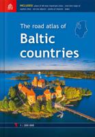
Wegenatlas The Road atlas of Baltic countries - Baltische Staten | Jana Seta

0
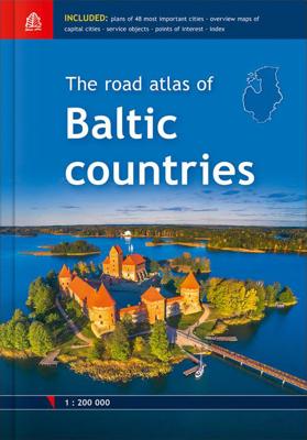
Mooie wegenatlas op schaal 1:200.000 van de Baltische landen op A-4 formaat in gebonden hardcover versie. Edition 2018 Latvia, Estonia and Lithuania road maps in scale 1:200'000 Atlas base map is supplemented with plans of the 48 largest cities in scale 1:20'000 Tallinn, Riga and Vilnius vicinity maps in scale 1:85'000 Information about point...

Verkopers met dit product

Verkoper
Bezorging
Prijs
DeZwerver.nl logo
DeZwerver.nl
2,95
51,50

Anderen bekeken ook

Wegenatlas The Road atlas of Baltic countries - Baltische Staten | Jana Seta
Mooie wegenatlas op schaal 1:200.000 van de Baltische landen op A-4 formaat in gebonden hardcover versie. Edition 2018 Latvia, Estonia and Lithuania road maps in scale 1:200'000 Atlas base map is supplemented with plans of the 48 largest cities in scale 1:20'000 Tallinn, Riga and Vilnius vicinity maps in scale 1:85'000 Information about points of interest and tourism services Index of place names Size 21,5 x 30,6 cm 254 pages Hardback
51,50
Wegenkaart - landkaart 781 Baltische Staten | Michelin
Zoals je van deze landkaart van Michelin mag verwachten is deze wegenkaart Baltische Staten zeer overzichtelijk en heeft een duidelijk helder kaartbeeld. De kaart geeft uitgebreid toeristische informatie weer. This Baltic States map from Michelin is part of their red national map series. These are perfect for route planning as well as getting around by car once you're there. They clearly mark out major roads and also show many of the more important minor roads. The map covers Estonia, Latvia, and Lithuania and includes several insets showing Tallinn at 1:10 000, Riga at 1:10 000 and Vinius at 1:10 000.   The map's simple folding design with durable paper cover, allows it to be read like a book and easily folded back together. Road numbers and intermediate distances are clearly displayed with the more scenic routes highlighted in green.   The map also features:   Political boundaries Regional and National Parks Important sights such as castles, ruins, and churches Driving Times and Dis…
11,95
Wegenatlas Lietuvos Autokeliu Atlasas - Litouwen | Jana Seta
Lithuania Road Atlas from the Riga based Jana Seta, in handy glovebox paperback format with street plans of 19 towns, including an enlargement for city centre of Vilnius, The whole country is covered at 1:200,000, showing detailed classification of road network with petrol stations, and railway lines with stops. Boundaries of national parks and other protected areas are marked and a range of symbols indicate tourist accommodations, campsites, various places of interest, etc. Picturesque towns and villages are highlighted. Colouring and graphics show forested areas and swamps and the atlas also shows the country’s administrative divisions. Latitude lines are at intervals of 5’ intervals and longitude at 10’. The atlas has an extensive index of localities.   The atlas also includes street plans of 19 towns at 1:20,000 or 1:25,000, annotated with places of interest and various facilities. For Vilnius the atlas has a plan of its central districts, plus a road map of the surrounding area h…
24,50
Fietsgids Bikeline Iron Curtain Trail 1 Finland - Baltische Staten | Esterbauer
Praktische fietsgids met detailkaarten, ingetekende route, informatie over overnachten en fietsenmakers, zwaarte en hoogteprofiel. In spiraalbinding, Engelstalig.  To properly live, breathe and experience history – that is the goal of the “Iron Curtain Trail”. From the Barents Sea to the Black Sea, this guide takes you along the Western border of the old Warsaw Pact countries, all the way across Europe. The route does not just connect European culture, history and sustainable tourism but it also provides historically interested cyclists with some spectacularly beautiful and varied landscapes and unique habitats that were able to emerge in the former border strip, which is today the European Green Belt. The maps in the revised edition are scaled larger at 1:120,000 from Helsinki to Riga, and from Grense Jakobselv to Vaalimaa it remains at 1:400,000. This volume describes the 4,000-kilometre-long part of the route from the Barents Sea to Riga.
18,50
Fietsgids Bikeline Baltic Sea Cycle Route - Iron curtain Trail 2 | Esterbauer
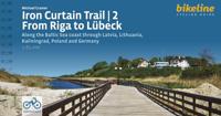
Praktische fietsgids voor een gedeelte van de Iron Curtain Trail, van Riga naar Lübeck. Met detailkaarten, ingetekende route, informatie over overnachten en fietsenmakers, zwaarte en hoogteprofiel. In spiraalbinding, Engelstalig.  The cycling guide contains all the information you need for your cycling vacation along the European Iron Curtain Trail between Riga and Lübeck: Precise maps, a detailed description of the route, a comprehensive list of overnight accommodation, numerous detail maps of cities and towns, and information about the most significant sights. And all that information comes with our bikeline pledge: The route described in this book has been tested and evaluated in person by the author! To assure that the book is as up-to-date as possible, we welcome corrections submitted by readers and local officials or businesses. We cannot, however, always check and confirm such changes before deadline. The maps The detail maps are produced in a scale of 1:85,000 (1 centimeter =…
19,50
Wegenatlas Road Atlas 2025 USA - Canada - Mexico - Verenigde Staten groot formaat | Michelin
De beroemde wegenatlas van Rand McNally nu als Michelin atlas op groot formaat, bijna dubbel A4. Elke staat een eigen, of soms zelfs twee pagina's. Uitgebreid register. Zoals de Amerikanen zelf zeggen: America's number 1 Road Atlas! Canada en Mexico staan er zeer beperkt in. Highlighting 51 road trips and scenic drives the Michelin's updated Large Format North America Road Atlas 2025 helps you enjoy the planning and the journey. Large-format maps and larger lettering for towns and sites (compared to the midsize atlas) make for easier reading while the tiled format flows maps from page to page—the ideal complement to GPS and online directions. Four jam-packed pages highlight selected US and Canadian national parks, with points of interest, hikes and drives.   Covers US, Canada & Mexico. Large grid map to quickly locate atlas pages. Easy-read text and mapping. Map pages are 36% larger than midsize atlas. Inspired ideas for outdoor fun and road trip adventures in the US and Canada…
19,95
Wegenatlas Philip's Easy to Read Road Atlas of Britain 2025 | A3-Formaat | Paperback | Philip's Maps
With the detail you need at a size you can read, the latest edition of 2025 Philip's Big Easy to Read Road Atlas of Britain is super-clear, super-sized and bang up-to-date in a large paperback format.   · Huge 1:150,000 scale (approx 2.4 miles to 1 inch) · Large super-sized pages (A3) · Large print place names, and large scale maps · 88 detailed town plans for easy navigation · Clear road colours, which are easier to read in the dark · Thousands of attractions clearly mapped · Special route planner section for arranging the best trips · Large print approach maps for all major cities · Durable paperback format   At last, a road atlas that everyone can read easily in or out of the car, no matter what the conditions. Restricted motorway information, a distance chart, and clearly labelled places of interest are just some of the features within this bestselling road atlas of Britain. Whether it's getting dark, or you just can't find your glasses, 2025 Philip's Big Easy to Read Road Atlas o…
23,95
Wegenatlas Philip's Easy to Read Road Atlas of Britain 2025 | A4-Formaat | Ringband | Philip's Maps
"The detail you need at a size you can read". The latest 2025 Philip's Easy to Read Road Atlas of Britain from the best-selling Road Atlas range has over 350 pages packed with exceptionally clear mapping and everything you need for exploring Britain. Practical A4-size with lie-flat spiral binding, it will enhance any journey.   · Clear maps packed with extra details for a better journey · Huge 1:150,000 scale (approx 2.4 miles to 1 inch) · Large print place names · Large print index · Super-clear 10-page route planner to create the best journeys · Thousands of attractions clearly mapped, including castles, theme parks, gardens, zoos and more. · Lie-flat spiral binding for easy use and planning   At last, a road atlas that everyone can read easily, in or out of the car, no matter what the conditions. With up-to-date mapping technology, your travels have never been easier to plan. This edition contains a wealth of useful information, including tourist attractions, to ensure the best pos…
27,50

Klanten-reviews van Wegenatlas The Road atlas of Baltic countries - Baltische Staten | Jana Seta

Er zijn nog geen beoordelingen voor dit productBen jij de eerste die een review plaatst?

Meer over Wegenatlas The Road atlas of Baltic countries - Baltische Staten | Jana Seta

Productomschrijving

Mooie wegenatlas op schaal 1:200.000 van de Baltische landen op A-4 formaat in gebonden hardcover versie.

  • Edition 2018
  • Latvia, Estonia and Lithuania road maps in scale 1:200'000
  • Atlas base map is supplemented with plans of the 48 largest cities in scale 1:20'000
  • Tallinn, Riga and Vilnius vicinity maps in scale 1:85'000
  • Information about points of interest and tourism services
  • Index of place names
  • Size 21,5 x 30,6 cm
  • 254 pages
  • Hardback

Productinformatie

    Verken gerelateerde categorieën

    Webshop.nl maakt gebruik van cookies. Ga je verder op onze website, ga dan akkoord met het plaatsen van cookies en de verwerking van deze data door ons en vermelde partners.