webshop.nl

Wegenatlas Japan Traveler's Atlas | Tuttle Publishing

0
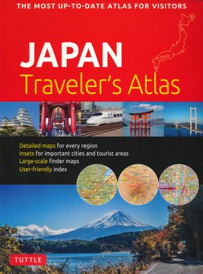
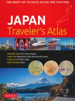
Finding your way around the various regions of Japan is a breeze with this handy Tuttle Japan Traveler's Atlas. Designed for the adventurous traveler and containing all the maps you'll need on your explorations, this atlas includes many views that are not available anywhere else.   The atlas is conveniently divided into the major regions of Japan:...

Verkopers met dit product

Webshop
Bezorging
Prijs
DeZwerver.nl logo
DeZwerver.nl
niet bekend
19,95

Anderen bekeken ook

Wegenatlas Japan Atlas - a Bilingual Guide | Kodansha
This title features: 21 large-scale maps of the regions of Japan, whichnclude all the officially registered cities, towns and villages.   The only atlas of its kind to feature place-names in both English and Japanese, Kodansha's perennial favorite has been newly revised to reflect the many changes that have resulted from the government's policy of consolidating Japanese cities, towns and villages. The volume includes: -- 21 large-scale maps of the regions of Japan, including Greater Tokyo and the Kanto area, the Greater Osaka area, and almost all of the officially registered Japanese municipalities; -- 10 maps of the major metropolitan areas, from Naha in Okinawa to Hiroshima, Kyoto, Nagoya, Tsukuba, Sapporo and many others; -- 7 maps featuring notable tourist and resort areas, including Fuji-Hakone, Nara, Kamakura, Nikko, etc.; -- 9 transportation maps, including road and intercity railway maps, Tokyo and Osaka subway and rail maps, and major domestic airline routes; -- 12 thematic m…
27,95
Atlas Atlas of Forgotten Places | White Lion Publishing
Explore the places that time forgot. Abandoned, mysterious, sleeping monuments around the world have been relegated to the margins of history, pushed off the map and out of sight. From ancient ruins and crumbling castles to more recent relics – an art deco New York subway station, a Soviet ghost town in the Arctic Circle, a flooded Thai mall teeming with aquatic life – Travis Elborough takes you on a journey into these strange, overlooked and disappearing worlds and immortalises their fates. Original maps and stunning colour photography accompany Travis Elborough’s moving historic and geographic accounts of each site. The featured locations are a stark reminder of what was, and the accounts in this investigative book help to bring their stories back to life, telling us what happened, when and why, and to whom. The book features 40 sites, including: Santa Claus, Arizona, USA: A festive tourist resort turned ghost town deep in the desert where once you could meet Santa Claus any day…
21,95
Wegenatlas Big Atlas Britain & Ireland 2025 | A3-Formaat | Ringband | Philip's Maps
Goede gedetailleerde wegenatlas van Groot-Brittannië, schaal 1:200.000 met een overzichtskaart van Ierland, schaal 1:1.000.000. Groot formaat, A3, en in ringband. 'Good balance between detail and clarity with excellent town maps' What Car? PHILIP'S is No. 1 in the UK for clear maps. The latest 2025 Philip's Big Road Atlas of Britain and Ireland, in a supersize large format, has fully updated mapping from the Philip's digital database alongside all the detail and information needed for successful travel.   * Top driving tips for safety and skill including how to parallel park * The best scenic routes, natural features and landscape highlighted for enhanced travelling * Practical 'more to view per page' A3 size * Main scale of maps: 3 miles to 1 inch = 1:200,000 for ease of use * Route-planning section for the easiest navigation * Special wide-vehicle access indicators for rural areas * 64 fully indexed and detailed town and city plans * City approach maps with named roads fo…
22,50
Atlas The Phantom Atlas | Simon & Schuster
Een fascinerend boekwerk met de grootste mythes, leugens en blunders die ooit op kaart zijn verschenen. In een luxe hardcover uitgave met mooie stofomslag. The Phantom Atlas is an atlas of the world not as it ever existed, but as it was thought to be. These marvellous and mysterious phantoms - non-existent islands, invented mountain ranges, mythical civilisations and other fictitious geography - were all at various times presented as facts on maps and atlases. This book is a collection of striking antique maps that display the most erroneous cartography, with each illustration accompanied by the story behind it. Exploration, map-making and mythology are all brought together to create a colourful tapestry of monsters, heroes and volcanoes; swindlers, mirages and murderers. Sometimes the stories are almost impossible to believe, and remarkably, some of the errors were still on display in maps published in the 21st century. Throughout much of the 19th century more than 40 different mapma…
34,95
Accommodatiegids Namibia Self-Drive Guide | Tracks4Africa
So, what is so special about the Tracks4Africa guide books? These are not guides written by armchair travellers or the personal experience of one person, but the combined experiences of a whole community of travellers. The T4A community travel far and wide – not by luxury bus or safari vehicle but on their own wheels. Sometimes they travel in groups and sometimes as lone rangers, but they always travel by motorbike, sedan or 4WD, therefore this guide is specifically aimed at self-drive travellers.   If you are a self-drive tourist, there are five things that you need to know when you are on the road: 1. Where to sleep. 2. Where to get fuel. 3. What to see and do. 4. Where to buy supplies. 5. Where to go in case of an emergency.   If you have the Tracks4Africa Self-Drive Guide as your travel companion, the answers to all these and many more questions will be at hand. If you are well prepared and well informed, you can really enjoy the unspoilt beauty of Africa! The Tracks4Afr…
52,50
Fotoboek Journey Through Indonesia | Tuttle Publishing
Whether readers are planning a trip to Bali or just fantasizing about one, Journey Through Indonesia makes for an unforgettable Indonesia travel guide. With hundreds of full-color photographs, Journey Through Indonesia takes readers on a tour of the world's most magnificent archipelago, a vast island nation with all the diversity of an entire continent. This vibrantly illustrated book is the perfect introduction to this most colorful of countries, for both Indonesian history enthusiasts, armchair travelers, and those planning explorations and adventures in Indonesia. Indonesia is Southeast Asia's largest nation, a place of endless contrasts and myriad cultures. This comprehensive Indonesian travel guide features over 400 stunning photographs, nine detailed maps, and insightful descriptions of the country's geography, culture, history, arts, crafts, and wildlife species. Journey Through Indonesia transports readers to each of Indonesia's significant regions including: The impressi…
27,95
Wegenatlas Navigator Camping and Caravanning - Atlas of Britain | Philip's Maps
THE MUST-HAVE ATLAS OF BRITAIN FOR CAMPING, CARAVANNING AND MOTORHOMES'A map that beats all others' - The Daily Telegraph'Scale, accuracy and clarity are without parallel' - Driving Magazine'No. 1 in the UK for clear maps' - Independent research surveyThe lure of the open road and British countryside has never waned and the appeal of independent exploration has surely grown in recent years. However, the adventurous need practical information about what lies ahead - from bridge heights, widths and weights to places to stop and enjoy.   Philip's Navigator Camping and Caravanning Atlas of Britain is the No. 1 Choice of Road Atlas for the independent travelling motorist and camper van owner. * Scale: 1.5 miles to 1 inch = 1:100,000 (Northern Scotland: 3 miles to 1 inch = 1:200,000)* Over 1,880 approved campsites located, plus essential advice from The Camping and Caravanning Club* Includes essential information for caravanning motorists: 6000 bridge height limits, 1500 bridge weight limit…
37,50
Treinreisgids Japan by Rail | Trailblazer Guides
Treinreishandboek van Japan, met beschrijvingen en praktische informatie over alle belangrijke spoorwegen en de steden onderweg, dwars door Japan (treinreizen) Japan is steeped in legend and myth, perhaps the greatest of which is the popular misconception that the country is simply too expensive to visit. The truth is that flights to Japan are cheaper than they've ever been, accommodation can be great value, while the warm hospitality which awaits every visitor costs nothing at all. The real secret to travelling around the country on a budget, however, is the Japan Rail Pass.   Use this comprehensive guide in conjunction with a rail pass to get the most out of a trip to Japan. * Practical information - planning your trip; when to go; suggested itineraries; what to take; festivals and events. * City guides and maps - where to stay, where to eat, what to see in 30 towns and cities; historical and cultural background.   * Kilometre-by-kilometre route guides - covering train journey…
28,50
Wegenatlas Ireland Comprehensive Road Atlas - Ierland | Collins
Duidelijke en gedetailleerde atlas voor Ierland in A4-formaat met ringband.   Clear, detailed road atlas of Ireland in a handy A4 spiral-bound format. This comprehensive, general purpose road atlas of the whole of Ireland is ideal for both business and pleasure use. The atlas contains a range of mapping scales: • 9 miles to 1 inch route planning map • Main maps at 3.2 miles to 1 inch, which are ideal for navigation. • A wide selection of detailed town centre street plans.   This edition boasts road mapping packed with detail showing colour classified road network, toll roads, land heights, the location of safety cameras, Blue Flag and Green Coast beaches, tourist information centres and a wide range of tourist attractions. There is also comprehensive guide information for visitors to Belfast, Cork, Dublin and Limerick. The locations of Speed Enforcement Zones, which highlight roads that have a high risk of accidents as identified by the Garda and the National Roads Authority, are incl…
14,95
Wegenatlas Road Atlas Britain 2025 - A4 | AA Publishing
Wegenatlas, met spiraal,  van Groot-Brittannie, Engeland, Wales en Schotland, met toeristische informatie This top-selling road atlas showcases Britain’s clearest mapping from the experts at the AA at a large 3.2 miles to 1 inch scale. Each page has been titled with its geographical location so you can turn to the page you need more easily. Wide and narrow minor roads, National Trust, English and World Heritage sites and hard-to-find places are shown. There are 112 city, town, port and airport plans, full colour country, unitary and administrative area map and a comprehensive 31,500 entry index with airports, top tourist sites and motorway services listed. Plus, scenic routes, over 1,800 golf courses and the top 300 AA-Inspected caravan and camping sites symbolised on the mapping. Motorway maps, ferry planning information and 5 district maps provide the essential motoring content for travelling the country. 10 pages of central London street mapping with index. District maps of Birm…
24,95

Klanten-reviews van Wegenatlas Japan Traveler's Atlas | Tuttle Publishing

Er zijn nog geen beoordelingen voor dit productBen jij de eerste die een review plaatst?

Meer over Wegenatlas Japan Traveler's Atlas | Tuttle Publishing

Productomschrijving

Finding your way around the various regions of Japan is a breeze with this handy Tuttle Japan Traveler's Atlas. Designed for the adventurous traveler and containing all the maps you'll need on your explorations, this atlas includes many views that are not available anywhere else.   The atlas is conveniently divided into the major regions of Japan:
  • Tokyo
  • Mt. Fuji & Around Tokyo
  • Central Honshu
  • Kyoto
  • Kansai
  • Hiroshima & Western Honshu
  • Northern Honshu
  • Hokkaido
  • Shikoku
  • Kyushu
  • Okinawa & the Southwest Islands
  Each of the 148 maps in this atlas is presented in a logical, easy-to-follow manner, with emphasis on the most frequently-visited areas. All cities, towns, villages, places of interest including nature reserves are indexed for quick reference.  
  • Comprehensive: detailed insets are given for all the major cities, travel destinations and business hubs in Japan.
  • Informative: Precise locations are indicated for all popular sights, hotels, restaurants, temples, shopping malls and other essential locations.
  • Practical: The handy size, well-designed key maps and comprehensive index help you find any place you are looking for quickly.
  • Reliable: No need to worry about cell service or battery—the maps in this atlas are thoroughly researched and regularly updated by the leading publisher of Asia Pacific maps.

Verken gerelateerde categorieën

Webshop.nl maakt gebruik van cookies. Ga je verder op onze website, ga dan akkoord met het plaatsen van cookies en de verwerking van deze data door ons en vermelde partners.