Wegenatlas Cuba Road Guide | Cuba Incentives

0
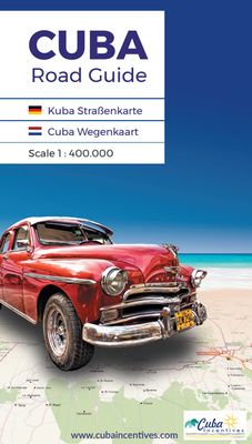
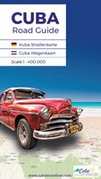
In de wegenkaart is Cuba opgedeeld in 11 uitklapbare kaarten met een schaal van 1:400.000. Met een handzaam formaat van 23 cm hoog en 13 cm breed is de wegenkaart ideaal om mee te nemen en onderweg te gebruiken. Een uitgeklapte kaart heeft het formaat van 23 cm hoog en 61 cm breed. Gedrukt op 170 gram stevig FSC papier. Stadsmappen op straatniveau...

Verkopers met dit product

Verkoper
Bezorging
Prijs
DeZwerver.nl logo
DeZwerver.nl
2,95
19,95

Anderen bekeken ook

Reisgids Cuba | Rough Guides
Zeer goede reisgids voor Cuba, geschikt voor zowel de georganiseerde maar vooral voor de zelfstandige reiziger. Boordevol informatie over reizen, slapen, eten, maar ook musea en cultuur. Voor Europese landen meestal completer en beter dan de Lonely Planet ! Discover Cuba with this comprehensive, entertaining, ‘tell it like it is’ Rough Guide, packed with comprehensive practical information and our experts’ honest and independent recommendations.   Whether you plan to visit Havana, drive in an old American car along the Malécon, visit a tobacco plantation or loll on a white-sand beach,The Rough Guide to Cuba will help you discover the best places to explore, sleep, eat, drink and shop along the way.   Features of The Rough Guide to Cuba: – Detailed regional coverage: provides in-depth practical information for each step of all kinds of trip, from intrepid off-the-beaten-track adventures, to chilled-out breaks in popular tourist areas. Regions covered include: Havana; Cienguegos …
23,95
Wegenkaart - landkaart Cuba | Nelles Verlag
Goede wegenkaart van Cuba. Aan beide kanten bedrukt. Met veel toeristische aanduidingen als nationale parken en culturele bezienswaardigheden. Prima leesbare kaart, nu ook op scheur- en watervast papier Folded road and tourist map of Cuba at 1:775 000 scale. Places of interest, national parks, and beaches are all highlighted and shaded-relief colouring clearly depicts the topography.   The map includes insets showing Varadero at 1:32 000, Camaguey at 1:15 000, Santiago de Cuba at 1:15 000, La Habana (Havana) at 1:15 000, Cienfuegos at 1:23 000 and Trinidad at 1:12 100. The legend is in four languages, including English.   For over 20 years Nelles maps have been renowned throughout the world for their quality, faithfulness to detail and up-to-dateness.    So that streets, ferry links, railway lines, etc are always up to date, Nelles are continuously upgrading their maps - with the help of their international team of correspondents. Roads are provided with an exact kilometerage. Sights …
11,95
Wegenkaart - landkaart 786 Cuba | Michelin
Zoals je van Michelin mag verwachten is deze kaart zeer overzichtelijk en heeft een duidelijk helder kaartbeeld. De kaart geeft uitgebreid toeristische informatie weer. Met register, afstanden en reistijden. Wegen worden naar verschillende klasse ingedeeld en - mooi van Michelin - de interessante mooie routes worden gemarkeerd met een groene streep.    Hindernissen voor automobilisten met caravans zijn gemarkeerd: steile hellingen, bergpassen of een anderzins moeilijke route. Bezienswaardigheden als een kasteel, religieus gebouw, ruine of grot is door een symbool goed te vinden. De perfecte overzichtskaart, eenzijdig gedrukt! Op één puntje na: er staan geen benzinepompen op ..... dat is dan jammer voor de vele reizigers met eigen auto. stadsplattegronden van Havana, Trinidad, Santiago de Cuba. Baracoa, Camagüey, Cienfuegos, Cuba, La Havane, Santiago de Cuba, Trinidad  
12,95
Wegenkaart - landkaart Cuba | Freytag & Berndt
Uitstekende kaart van Cuba. Met index, toeristische informatie en afstanden in kilometers.De berijdbare wegen zijn goed weergeven, zowel de hoofdwegen als provinciale en lokale wegen; wegnummers worden vermeld. Afstanden tussen plaatsen zijn in kilometers op de kaart ingetekend. In het kaartbeeld wordt door middel van schaduw het reliëf weergegeven en soms enkele punten in het landschap met de daadwerkelijke hoogte. Provinciegrenzen zijn goed terug te vinden, nationale parken en reservaten ook. Met allerhande symbolen worden toeristische bezienswaardigheden weergegeven als monumenten, historisch belangrijke plekken en uitzichtpunten. In bepaalde plaatsen zijn hotels en campings te vinden, luchthavens, treinverbindingen en havens vindt u er ook op! Overview map with street plans of Havana, Cienfuegos, Camagüey and Santiago de Cuba, plus enlargements of the Playa del Este area east of the capital and the Varadero Peninsula. The main map presents the island’s topography by bold relief sh…
14,95
Reisgids Cuba | Insight Guides
Een rijk geillustreerde reisgids met diepgaande teksten: één van de beste reisgidsen die er bestaan. Eerste deel bestaat uit een beschrijving van de unieke aspecten van de regio, daarna een deel echte reisgids en als afsluiting een deel met praktische informatie. De uitstekende informatie wordt vergezeld van prachtige foto's en heldere kaarten. Niet alleen om mee te nemen, maar ook om vooraf en zelfs achteraf weer in de stemming te komen. Engelstalig. Insight Guide to Cuba is a pictorial travel guide in a magazine style providing answers to the key questions before or during your trip: deciding when to go to Cuba, choosing what to see, from exploring old Havana to discovering Valle de Vinales or creating a travel plan to cover key places like Santiago, Santa Clara. This is an ideal travel guide for travellers seeking inspiration, in-depth cultural and historical information about Cuba as well as a great selection of places to see during your trip. The Insight Guide CUBA covers: Old Ha…
23,95
Wegenkaart - landkaart Cuba West | ITMB
Een degelijke wegenkaart met aanduidingen van o.a. nationale parken, vliegveld. Als overzichtskaart goed te gebruiken. his is a brand new title for ITMB and reflects the growing interest in travel to Cuba resulting from improved relations with the USA. Licenses to fly into the country from a dozen cities have already been approved; 60 more are awaiting approval. All are for flights into Havana and Varadero airports – in other words, the western half of the country. ITMB already has an exceptionally good map of the entire country. We also have a separate map of Havana. This map expands the scale and opens the information for the western half of the island nation as a double-sided map, with the portion west of Havana (La Habana) to Pinar del Rio province in the far west and south to the Isla de la Juventud (better known, but mis-named, as the Bay of Pigs Invasion Site). This side also has an excellent map of the Varadero beach resort area as an inset, and a map of greater Havana. The ot…
13,95
Wegenkaart - landkaart Cuba east | ITMB
Goede dubbelzijdige wegenkaart waarbij met kleurgebruik de hoogte en natuurkundige aspecten wat duidelijker wordt weergegeven dan op andere kaarten. De wegen worden aangeduid met de bekende wegnummers en afstanden tussen steden staan weergegeven. Met symbolen worden toeristisch belangrijke aspecten getoond en ook bijvoorbeeld campings. Nationale parken zijn goed terug te vinden op deze kaart.  Cuba is the fastest-growing travel destination in the world. Initially, attention has favoured Havana and the western portion of the island, but tourism is rapidly transforming the eastern portion of the country into a more rustic, natural travel experience than the over-heated Varadero resorts or hectic Havana. Until now, there has never been a map of the eastern half of Cuba; now ITMB provides one! The map covers from Varadero to the easternmost tip of Guantanamo Province on a double-sided map. Insets of Varadero, Cienfuegos, Trinidad, and Santiago are included. Naturally, the road network is …
13,95
Cuba
Cuba
Capitool Cuba: de ideale reisgids voor jouw reis naar Cuba!Een luxe reisgids boordevol informatieMet een zorgvuldig samengestelde inhoud van hoge kwaliteitBestand tegen intensief gebruik voor, tijdens én na je reisMet de mooiste illustraties en foto'sEen gids om te bewaren als een prachtige herinneringCuba is een fascinerend land. De prachtige Cubaanse palmstranden, zoals bij Varadero en Cayo Largo, genieten wereldfaam. De levendige, kleurrijke hoofdstad Havana staat vol historische gebouwen, prachtige villa's en interessante musea. Trinidad staat bekend om zijn koloniale architectuur. Ook de rest van het eiland zit vol met aangename verrassingen; indrukwekkend berglandschap, moerasgebied, tabaksvelden en diepblauwe lagunes wisselen elkaar af. Kortom: in Cuba kijk je je ogen uit.Alles in één reisgidsMet de reisgids Capitool Cuba ben je verzekerd van een reisgids boordevol informatie, mooie plattegronden en de meest handige tips. De reisgids is opgedeeld in de vijf verschillende streken…
29,99
Reisgids Pocket Guide Cuba | Berlitz
Handige reisgids op zakformaat met korte, bondige en duidelijke informatie over de eilanden en bezienswaardige plekken. Plan your trip, plan perfect days and discover how to get around - this pocket-sized guide with new bi-lingual dictionary is a convenient, quick-reference companion to discovering what to do and see in Cuba, from top attractions like Havana and Varadero to hidden gems. This will save you time, and enhance your exploration of this fascinating country.   · Compact, concise, and packed with essential information, this is an iconic on-the-move companion when you're exploring Cuba · Covers Top Ten Attractions, including Baracoa, Trinidad and the Viñales Valley and Perfect Day itinerary suggestions · Nifty new bi-lingual dictionary section makes this the perfect portable package for short trip travellers · Includes an insightful overview of landscape, history and culture · Handy colour maps on the inside cover flaps will help you find your way around · Essential practical …
10,95
Wandkaart Cuba, 92 x 61 cm | National Geographic
The most accurate and richly detailed reference map available for the iconic Caribbean island nation, our Cuba Classic Map contains National Geographic’s proprietary fonts and world recognized border bands in a bright and appealing color palette with striking blue oceans on a crisp white background.   Cuba’s many offshore islands, reefs, and rivers are noted, as are sites of interest. Ocean bathymetry with depth curves and soundings, peak elevations, and handcrafted shaded relief provide topographical detail. Jamaica, the Cayman Islands, the Florida Keys, and most of the Bahamas and Haiti are shown, presenting Cuba in the context of its important geographical position in the Caribbean.   Cuba contains thousand of place names, accurate political boundaries, and infrastructure making it the perfect reference for student, home, or business.   Additional content unique to this map includes: Sites of interest including national parks and reserves Geographic equivalents provide translatio…
34,95

Klanten-reviews van Wegenatlas Cuba Road Guide | Cuba Incentives

Er zijn nog geen beoordelingen voor dit productBen jij de eerste die een review plaatst?

Meer over Wegenatlas Cuba Road Guide | Cuba Incentives

Productomschrijving

In de wegenkaart is Cuba opgedeeld in 11 uitklapbare kaarten met een schaal van 1:400.000. Met een handzaam formaat van 23 cm hoog en 13 cm breed is de wegenkaart ideaal om mee te nemen en onderweg te gebruiken. Een uitgeklapte kaart heeft het formaat van 23 cm hoog en 61 cm breed. Gedrukt op 170 gram stevig FSC papier.

Stadsmappen op straatniveau van de volgende plaatsen:
Baracoa - Bayamo - Camagüey - Cienfuegos - Gibara - Guardalavaca - Havana - Holguín - Matanzas - Pinar del Río - Playa Larga - Remedios - Sancti Spíritus - Santa Clara - Santiago de Cuba - Trinidad - Varadero - Viñales

Verken gerelateerde categorieën

Webshop.nl maakt gebruik van cookies. Ga je verder op onze website, ga dan akkoord met het plaatsen van cookies en de verwerking van deze data door ons en vermelde partners.