Wandkaart Spanje, 70 x 50 cm | CNIG - Instituto Geográfico Nacional

0
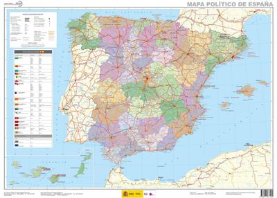
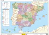
Administrative provinces of Spain shown in bright colours on a wall map at 1:2,250,000, size 70 x 50cm (27.5" x 20" approx), from IGN/CNIG - the country’s civilian survey organization, plus a panel of regional flags. Each province is presented in a different colour and the map also shows boundaries and names of administrative regions. Town symbols...

Verkopers met dit product

Verkoper
Bezorging
Prijs
DeZwerver.nl logo
DeZwerver.nl
5,95
16,95

Anderen bekeken ook

Wandkaart Frankrijk, België en Nederland, 60 x 77 cm | National Geographic
Our classic wall map of France, Belgium, and the Netherlands shows political boundaries, major highways and roads, cities and towns, and a wealth of other incredibly accurate geographic detail.  n France the map shows the division of the country into regions, with a list of their names and regional capitals (curiously, Corsica is not included on the map – what would Napoleon think of that?). The map also provides plenty of names of both geographical features (Pyrenees, Cevennes, etc) and the country’s traditional historical regions (Gascony, Maine, Bourbonais, etc). National parks are highlighted.   Within Belgium the map indicates the division into Flanders, Wallonia and the Brussels Region and in the Netherlands boundaries of the country’s administrative provinces are marked.   Topography is shown by relief shading and within the Netherlands the areas below the sea level are also indicated. The map shows the network of main road and rail connections, local airports, as well as ferry…
31,95
Wandkaart 22074 Frankrijk, België en Nederland, 60 x 77 cm | National Geographic
>Our classic wall map of France, Belgium, and the Netherlands shows political boundaries, major highways and roads, cities and towns, and a wealth of other incredibly accurate geographic detail.    France the map shows the division of the country into regions, with a list of their names and regional capitals (curiously, Corsica is not included on the map – what would Napoleon think of that?). The map also provides plenty of names of both geographical features (Pyrenees, Cevennes, etc) and the country’s traditional historical regions (Gascony, Maine, Bourbonais, etc). National parks are highlighted. Within Belgium the map indicates the division into Flanders, Wallonia and the Brussels Region and in the Netherlands boundaries of the country’s administrative provinces are marked. Topography is shown by relief shading and within the Netherlands the areas below the sea level are also indicated. The map shows the network of main road and rail connections, local airports, as well as ferry …
25,95
Wegenkaart - landkaart Mauritania - Mauritanië en Westelijke Sahara | Gizi Map
Tweetalig Mauritania and Western Sahara with excellent topographic information on an indexed map with a street plan of central Nouakchot. Vivid altitude colouring with graphics for deserts, flood plains and salt flats shows the terrain. Oases, water wells and numerous spot heights are marked and the map provides plenty of names of geographical features: peaks, mountain chains and rock outcrops, plains, etc.    Road network shows distances on main roads and includes dirt tracks. The map also shows locations of local airfields and the route of the iron ore railway line from the mines at Zouérat to the coast. Symbols highlight various places of tourist interest including world heritage sites, forts and archaeological remains, national parks and protected areas, beaches, etc.   Names of main towns and important geographical features are also given in Arabic. Internal administrative boundaries are shown with names of the provinces. The map had latitude and longitude lines at intervals of 1…
15,95
Wandkaart China - political, 95 x 69 cm | Gizi Map
Een wandkaart van China waarop de politieke grenzen en steden tweetalig staan weergeven. Natuurkundige aspecten zijn weggelaten, maar dat komt de politieke en bestuurlijke indeling duidelijk ten goede. Afmetingen: 69cm.x 95cm. (hxb) An administrative wall map of China at 1:6,500,000, size 96 x 68cm (38" x 27" approx), from Gizi Map showing the division of the country into provinces. All place names are given in both Chinese and Latin alphabet. Hong Kong and the Pearl River Delta are presented in a greater detail on an inset.   China’s provinces are shown in bright contrasting colours. Town symbols indicate the size of the population. Main airports and ports are marked, as well as coastal and international shipping routes, Topographic information is limited to the network of rivers. Latitude and longitude lines are at 5° intervals. The map is not indexed. Multilingual map legend includes English. An inset shows Hong Kong and the Pearl River Delta region at 1:1,000,000.
46,95
Wegenkaart - landkaart Sudan and South Sudan | Gizi Map
Sudan and South Sudan as separate countries on an excellent indexed map at 1:2,500,000 from Gizi Maps with detailed presentation of the topography, administrative divisions, street plans of Khartoum and Juba, etc. Excellent presentation of the terrain in the publisher’s characteristic style provides a vivid picture of the region’s geography: bold altitude colouring with plenty of spot heights and names of peaks, mountain ranges, etc, plus additional graphics for flood plains, swamps, salt flats, deserts, lava fields, wadis and water wells. National parks or other protected areas and interesting natural sites are highlighted. The map indicates the boundary of the disputed Abyei area and shows the internal administrative boundaries and names of the provinces. Within North Sudan names of larger towns and of the provinces are also given in Arabic. Where appropriate, alternative versions of town names are provided (Khartoum/Al Khartum, Omdurman/Umm Durman, etc). The map shows the road n…
15,95
Wegenkaart - landkaart Yemen - Jemen | Gizi Map
Yemen, including the Gulf of Aden, at 1:1,250,000 on an excellent and informative map from Gizi Maps, with a street plan of central Sana’a and enlargements of the environs of the capital and Aden, plus the Aden Peninsula.   The map has the publisher’s characteristic bold altitude colouring and plenty of names of various mountain chains, peaks, deserts, etc. Graphics indicate swamps, salt flats, wadis, deserts, lava flows, water wells, oasis, etc, to provide a vivid picture of the country’s topography. Names of the larger towns, provinces and many geographical features are given in both Latin and Arabic alphabets; all other place names are shown only transliterated.   Coverage extends southward to the northern coastline of the Horn of Africa, including the whole of Djibouti and most of Eritrea. Within the Gulf of Aden the Internationally Recommended Transit Corridor (IRTC) is marked, as well as other ferry and shipping routes including those leading to the Socotra Archipelago and in th…
15,95
Wegenkaart - landkaart Taiwan and Taipei | ITMB
Een degelijke kaart met aanduidingen van o.a. nationale parken, vliegveld, benzinepomp, dirt-roads en kleine plattegrond van hoofdstad. Als overzichtskaart goed te gebruiken. Wegenkaart Taiwan en stadsplan Taipei   Combining a map of Taiwan with a street plan of Taipei. The map of the island shows the road and rail networks, indicating local airports and airfields, national parks and scenic areas, places of interest and beaches. The country’s administrative divisions are marked, with names of the provinces and provincial capitals shown in both Roman alphabet and Chinese. All other place names are in Roman alphabet only. Topography is shown by altitude colouring with spot heights. Brief descriptions are provided for main places of interest and a separate inset shows the route of the Taiwan Highspeed Railway.   On the reverse is an street plan of Taipei, highlighting places of interest, railway and metro stations, bus and ferry terminals, selected accommodation, etc. Street and district…
14,50
Wandkaart Afrika, politiek & antiek, 61 x 78 cm | National Geographic
Mooie wandkaart van Afrika, staatkundig, met rustig kleurgebruik en helder kaartbeeld, Ondanks het wat kleiner formaat staan er toch heel wat topografische details op vermeld.    Kaart is up-to-date, alleen Zuid Sudan wordt niet als een apart land weergegeven.   Our executive-style political map of Africa features country boundaries, place names, bodies of water, airports, major highways and roads, and much more. Astounding detail and boardroom quality make this map excellent for reference in your home or office.   The map presents Africa at 1: 14,244,000 and coverage includes the whole of the Mediterranean Basin, extending north to London. Islands in the Atlantic and the Indian Ocean are included on a separate inset. The base map has relief shading to show the continent’s topography, with additional graphics indicating deserts, swamps, salt flats, etc. The map shows the names of the main geographic features such as mountain ranges, deserts, peaks etc. Heights are given in metres, exc…
31,95
Wandkaart 20430 Afrika, politiek & antiek 61 x 78 cm | National Geographic
Mooie wandkaart van Afrika, staatkundig, met rustig kleurgebruik en helder kaartbeeld, Ondanks het wat kleiner formaat staan er toch heel wat topografische details op vermeld.    Kaart is up-to-date, alleen Zuid Sudan wordt niet als een apart land weergegeven.   Our executive-style political map of Africa features country boundaries, place names, bodies of water, airports, major highways and roads, and much more. Astounding detail and boardroom quality make this map excellent for reference in your home or office.   The map presents Africa at 1: 14,244,000 and coverage includes the whole of the Mediterranean Basin, extending north to London. Islands in the Atlantic and the Indian Ocean are included on a separate inset. The base map has relief shading to show the continent’s topography, with additional graphics indicating deserts, swamps, salt flats, etc. The map shows the names of the main geographic features such as mountain ranges, deserts, peaks etc. Heights are given in metres, …
24,95
Wegenkaart - landkaart Lybië - Libya | Gizi Map
Libya at 1:1,750,000 on an indexed road map from Gizi Map with exceptionally fine and detailed presentation of its physical geography, oil and gas wells and pipelines, water aqueducts, ancients sites and other places of interest, etc. Names of larger towns and selected smaller locations, as well as of many topographic features are also shown in Arabic.   The map provides a very fine presentation of the country’s geography through relief shading and graphics for sandy or stone deserts, swamps, salt flats, oasis, and water wells, plus numerous spot heights and plenty of names of mountain ranges, wadis, etc. Road network shows desert tracks and gives distances on main routes. Railway lines are included and domestic airports/aerodromes are marked. The map also shows oil or gas wells and pipelines, water aqueducts and boundaries of administrative provinces. Symbols indicate locations with campsites or youth hostels, various places of interest including archaeological sites and natural curi…
15,95

Klanten-reviews van Wandkaart Spanje, 70 x 50 cm | CNIG - Instituto Geográfico Nacional

Er zijn nog geen beoordelingen voor dit productBen jij de eerste die een review plaatst?

Meer over Wandkaart Spanje, 70 x 50 cm | CNIG - Instituto Geográfico Nacional

Productomschrijving

Administrative provinces of Spain shown in bright colours on a wall map at 1:2,250,000, size 70 x 50cm (27.5" x 20" approx), from IGN/CNIG - the country’s civilian survey organization, plus a panel of regional flags. Each province is presented in a different colour and the map also shows boundaries and names of administrative regions. Town symbols and names indicate their size and administrative status. The map shows the network of main roads and railways. Latitude and longitude lines are drawn at intervals of 1°. Map legend is in Spanish only.   

Next to the map is a panel listing Spain’s autonomous regions, including Ceuta and Melilla, each with its flag, plus a list of its constituent provinces and their capitals.

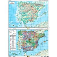
Mapa General de España (Península Ibérica, Baleares, Canarias, Ceuta, Melilla y posesiones españolas en el norte de África) a escala 1:2.000.000, con división autonómica. Proyección Lambert.

Productinformatie

    Verken gerelateerde categorieën

    Webshop.nl maakt gebruik van cookies. Ga je verder op onze website, ga dan akkoord met het plaatsen van cookies en de verwerking van deze data door ons en vermelde partners.