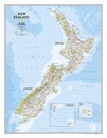
Wandkaart New Zealand - Nieuw Zeeland 60 x 77 cm | National Geographic

0
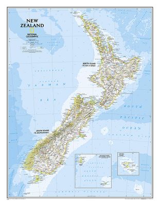
Mooie heldere wandkaart van Nieuw Zeeland met het Noordereiland en Zuidereiland op dezelfde kant afgebeeld. Veel plaatsnamen, goed kleurgebruik waardoor hoogteverschillen en bijvoorbeeld nationale parken goed zichtbaar zijn.   The reference map of New Zealand uses National Geographic's signature Classic style with blue ocean and stunning shaded re...

Verkopers met dit product

Webshop
Bezorging
Prijs
DeZwerver.nl logo
DeZwerver.nl
niet bekend
31,95

Anderen bekeken ook

Wegenkaart - landkaart Planning Map New Zealand - Nieuw Zeeland | Lonely Planet
Durable and waterproof, with a handy slipcase and an easy-fold format, Lonely Planet New Zealand Planning Map is your conveniently-sized passport to traveling with ease. Get more from your map and your trip with images and information about top country attractions, itinerary suggestions, a transport guide, planning information, themed lists and practical travel tips. With this easy-to-use, full colour navigation tool in your back pocket, you can truly get to the heart of New Zealand, so begin your journey now! Durable and waterproof Easy-fold format and convenient size Handy slipcase Full colour and easy-to-use Before-you-go info Beautiful imagery Tailored itineraries Can't-miss regional highlights Detailed town index Transport planner Themed lists Covers Auckland, Bay of Islands, Hauraki Gulf, Waiheke Island, Rotorua, Bay of Plenty, Coromandel Peninsula, Wellington, Abel Tasman National Park, Marlborough Wine Region, Taupo, Tongariro Alpine Crossing, Matamata, Waitomo…
10,95
Reisgids New Zealand - Nieuw Zeeland | Rough Guides
Zeer goede reisgids voor zowel de georganiseerde maar vooral voor de zelfstandige reiziger. Boordevol informatie over reizen, slapen, eten, maar ook musea en cultuur. Voor veel landen meestal completer en beter dan de Lonely Planet ! This practical travel guide to New Zealand features detailed factual travel tips and points-of-interest structured lists of all iconic must-see sights as well as some off-the-beaten-track treasures. Our itinerary suggestions and expert author picks of things to see and do will make it a perfect companion both, ahead of your trip and on the ground. This New Zealand guide book is packed full of details on how to get there and around, pre-departure information and top time-saving tips, including a visual list of things not to miss. Our colour-coded maps make New Zealand easier to navigate while you're there. This guide book to New Zealand has been fully updated post-COVID-19 and it comes with a free eBook.   The Rough Guide to New Zealand covers: Auckland…
27,95
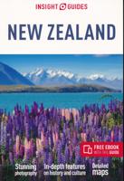
Reisgids New Zealand - Nieuw Zeeland | Insight Guides
Een rijk geillustreerde reisgids met diepgaande teksten: één van de beste reisgidsen die er bestaan. Eerste deel bestaat uit een beschrijving van de unieke aspecten van de regio, daarna een deel echte reisgids en als afsluiting een deel met praktische informatie. De uitstekende informatie wordt vergezeld van prachtige foto's en heldere kaarten. Niet alleen om mee te nemen, maar ook om vooraf en zelfs achteraf weer in de stemming te komen From deciding when to go, to choosing what to see when you arrive, this is all you need to plan your trip and experience the best of New Zealand, with in-depth insider information on must-see, top attractions like Rotorua, Rakiura National Park and Otago, and hiddencultural gems.   · Insight Guide New Zealand is ideal for travellers seeking immersive cultural experiences, from exploring Maori culture, to discovering New Zealand's food and wine · In-depth on history and culture: enjoy special features on wildlife, New Zealand's people and Maori handcra…
25,95
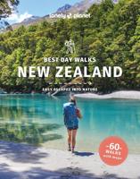
Wandelgids Best Day Walks New Zealand - Nieuw Zeeland | Lonely Planet
Lonely Planet heeft een nieuwe serie uitgebracht: Best Day Walks in verschillende landen. Het zijn de - door Lonely Planet uitgekozen - mooiste wandelingen verspreid over het land. Goed beschreven, met een schetsmatige kaart erbij ... het werkt heel stimulerend met mooie foto's! Lonely Planet's Best Day Walks New Zealand is your passport to 60 easy escapes into nature. Stretch your legs outside the city by picking a hike that works for you, from a few hours to a full day, from easy to hard. Climb ancient volcanoes, view amazing vistas, and scale tall mountains. Get to the heart of New Zealand and begin your journey now!       Inside Lonely Planet's Best Day Walks New Zealand Travel Guide:   Up-to-date information - all businesses were rechecked before publication to ensure they are still open after 2020’s COVID-19 outbreak   Colour maps and images throughout   Special features - on New Zealand's highlights for walkers, kid-friendly walks, accessible trails and what to take   Best for……
22,50
Wandkaart India, 60 x 77 cm | National Geographic
See India as only National Geographic can depict it. This new reference map is one of the most detailed and comprehensive ever published for India and southern Asia. It includes India, Sri Lanka, Nepal, Bangladesh, Bhutan, Tajikistan, and portions of China, Pakistan, Afghanistan, and Myanmar. The India map is punctuated with thousands of place names, and embellished with shaded relief which highlights the region's dramatic topography in such places as the Tibetan Plateau and the Himalaya.
31,95
Wandkaart Cuba, 92 x 61 cm | National Geographic
The most accurate and richly detailed reference map available for the iconic Caribbean island nation, our Cuba Classic Map contains National Geographic’s proprietary fonts and world recognized border bands in a bright and appealing color palette with striking blue oceans on a crisp white background.   Cuba’s many offshore islands, reefs, and rivers are noted, as are sites of interest. Ocean bathymetry with depth curves and soundings, peak elevations, and handcrafted shaded relief provide topographical detail. Jamaica, the Cayman Islands, the Florida Keys, and most of the Bahamas and Haiti are shown, presenting Cuba in the context of its important geographical position in the Caribbean.   Cuba contains thousand of place names, accurate political boundaries, and infrastructure making it the perfect reference for student, home, or business.   Additional content unique to this map includes: Sites of interest including national parks and reserves Geographic equivalents provide translatio…
34,95
Wandkaart - Magneetbord Australasia - Australië, Nieuw Zeeland en deel Oceanië, 120 x 100 cm | Maps International
Fraaie politieke kaart van het continent, waarbij vooral de politieke aspecten heel duidelijk te lezen zijn. Alle landen hebben verschillende kleuren, steden en belangrijke verbindingen zijn goed te vinden.   De kaart wordt in deze versie gelijmd op een plaat, voorzien van een mooie aluminium lijst en een ophangsysteem wordt meegeleverd. Daarnaast krijgt u een bakje bijgeleverd dat u er aan kunt bevestigen voor pennen, stiften of magneetjes.   Maps International's Australasia political wall map shows Papua New Guinea in the North of the continent down to Tasmania and New Zealand in the south.   This political wall map of Australasia features countries marked in different colours, with international borders clearly shown. The map's key shows the flags from the countries displayed in this map (Australia, New Zealand and Papua New Guinea). This political wall map of Australasia also contains city population detail, capital cities and all the major towns and cities in this continent.   Ma…
269,-
Wandkaart - Prikbord Australasia - Australië, Nieuw Zeeland en deel Oceanië, 120 x 100 cm | Maps International
Fraaie politieke kaart van het continent, waarbij vooral de politieke aspecten heel duidelijk te lezen zijn. Alle landen hebben verschillende kleuren, steden en belangrijke verbindingen zijn goed te vinden.   De wandkaarten op prikbord worden geleverd met een aluminium lijst en een eenvoudig te monteren ophangsysteem. Zij zijn geschikt voor allerhande markeringsystemen als vlaggetjes en prikkers.   Maps International's Australasia political wall map shows Papua New Guinea in the North of the continent down to Tasmania and New Zealand in the south.   This political wall map of Australasia features countries marked in different colours, with international borders clearly shown. The map's key shows the flags from the countries displayed in this map (Australia, New Zealand and Papua New Guinea). This political wall map of Australasia also contains city population detail, capital cities and all the major towns and cities in this continent.   Maps International's Asia map is available eithe…
185,-
Reisgids Best Road Trips New Zealand - Nieuw Zeeland | Lonely Planet
Discover the freedom of the open road with Lonely Planet's New Zealand's Best Road Trips. This trusted travel companion features 25 amazing drives, from 3-day escapes to 2-week adventures. Cruise Bay of Islands, meander to vineyard restaurants on Waiheke Island, and spot whales off Kaikoura Coast.   Get to New Zealand, rent a car, and hit the road! Inside Lonely Planet's New Zealand's Best Road Trips: Itineraries for classic road trips plus other lesser-known drives with expert advice to pick the routes that suit your interests and needs Full-colour route maps - easy-to-read, detailed directionsDetours - delightful diversions to see Italy's highlights along the way Link Your Trip - cruise from one driving route to the next Insider tips - get around like a local, avoid trouble spots and be safe on the road - local driving rules, parking, toll roadsStretch Your Legs - the best things to do outside the car Essential info at your fingertips - hours of operation, phone numbers, websites, p…
22,95
Reisgids New Zealand | Marco Polo
Handige en overzichtelijke, kleine reisgids voor een eerste kennismaking met de vakantiebestemming. Globale uitklapkaart achterin, makkelijk binnenzakformaat. Let Marco Polo Pocket New Zealand guide you around this beautiful country. Explore New Zealand with this handy, pocket-sized, authoritative guide, packed with Insider Tips. Discover boutique hotels, authentic restaurants, the country's trendiest places, and get tips on shopping and what to do on a limited budget. There are plenty of ideas for travel with kids, and a summary of all the festivals and events that take place in New Zealand. Let Marco Polo show you all this wonderful country has to offer.Discover a unique natural paradise and an amazingly varied landscape - paradise beaches with a Mediterranean climate, frozen glaciers in the high mountains, deep fjords, tangled forests with gigantic trees, thermal areas where the ground boils over and immerse yourself in the exotic appeal of the Polynesian culture of the original Ma…
14,95

Klanten-reviews van Wandkaart New Zealand - Nieuw Zeeland 60 x 77 cm | National Geographic

Er zijn nog geen beoordelingen voor dit productBen jij de eerste die een review plaatst?

Meer over Wandkaart New Zealand - Nieuw Zeeland 60 x 77 cm | National Geographic

Productomschrijving

Mooie heldere wandkaart van Nieuw Zeeland met het Noordereiland en Zuidereiland op dezelfde kant afgebeeld. Veel plaatsnamen, goed kleurgebruik waardoor hoogteverschillen en bijvoorbeeld nationale parken goed zichtbaar zijn.   The reference map of New Zealand uses National Geographic's signature Classic style with blue ocean and stunning shaded relief. The map shows this island nation in great detail, from the subtropical North Island (Te Ika-a-Maui) to the glacial carved valleys of Fiordland on the South Island (Te Waipounamu). The North Island is best known for large volcanic lakes and the cities of Auckland and Wellington. The South Island is famous for the Southern Alps that run along the spine of the island. The highest point in the country is Aoraki (Mount Cook) and is found in the Southern Alps.   The first settlers of New Zealand were the Maori from Polynesia, the names on the map reflect this history with both English and Maori variants. The map also features a transportation network including highways, roads, passenger railroads, and major airports. All National Parks are also shown.   The laminated version of the map is encapsulated in heavy-duty 1.6 mil laminate. The laminated map can be framed easily and since there is no need for heavy glass the frame can be much lighter and less expensive.   All proceeds from the purchase of a National Geographic map help support the Society's vital exploration, conservation, scientific research, and education programs.   Map Scale = 1:2,300,000 Sheet Size = 23.5'' x 30.25'' (60 x 77 cm)

Verken gerelateerde categorieën

Webshop.nl maakt gebruik van cookies. Ga je verder op onze website, ga dan akkoord met het plaatsen van cookies en de verwerking van deze data door ons en vermelde partners.