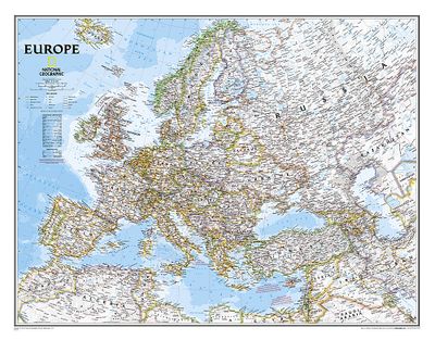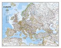
Wandkaart Europa, politiek, 114 x 88 cm

0
This colorful Europe political map clearly shows country boundaries, capitals, many major cities, bodies of water, airports, major highways and roads, and much more....

Verkopers met dit product

Verkoper
Bezorging
Prijs
DeZwerver.nl logo
DeZwerver.nl
5,95
45,95

Anderen bekeken ook

Wandkaart Europa Europe politiek | Michelin
De Michelin kaart van Europa met meer dan 40 Europese landen is actueel, gedetailleerd, nauwkeurig, praktisch en internationaal. Landgrenzen zijn goed leesbaar. De grote wegen staan met afstanden en wegnummer vermeld.   Educational and decorative, this Europe political wall map is ideal for use in both home and office. Updated annually and beautifully coloured, this map highlights flags of each European country and includes information on population, surface area and density. This map also shows main European road networks, cities and capitals. This map is presented on a scale 1/4,300,000 and measures 100 x 122 cm.   MICHELIN Europe political wall map features:   * Flags for each European countries * Stastical information: population, surface area, density * Main road networks * Main cities of Europe and capitals
28,95
Wandkaart Afrika, politiek & antiek, 61 x 78 cm | National Geographic
Mooie wandkaart van Afrika, staatkundig, met rustig kleurgebruik en helder kaartbeeld, Ondanks het wat kleiner formaat staan er toch heel wat topografische details op vermeld.    Kaart is up-to-date, alleen Zuid Sudan wordt niet als een apart land weergegeven.   Our executive-style political map of Africa features country boundaries, place names, bodies of water, airports, major highways and roads, and much more. Astounding detail and boardroom quality make this map excellent for reference in your home or office.   The map presents Africa at 1: 14,244,000 and coverage includes the whole of the Mediterranean Basin, extending north to London. Islands in the Atlantic and the Indian Ocean are included on a separate inset. The base map has relief shading to show the continent’s topography, with additional graphics indicating deserts, swamps, salt flats, etc. The map shows the names of the main geographic features such as mountain ranges, deserts, peaks etc. Heights are given in metres, exc…
31,95
Wandkaart USA - Verenigde Staten, politiek, 110 x 77 cm | National Geographic
  Het klassieke kaartbeeld van National Geographic, de grenzen van de staten van Amerika zijn apart gekleurd. De wandkaart is heel gedetailleerd met veel plaatsen, wegen, rivieren en nationale parken, het reliëf wordt met schaduw aangegeven. Geplastificeerde versie.   The National Geographic Classic United States map uses bright color bands to outline each state. Capitals, major cities, selected towns, bodies of water, highways, and national parks are all shown. Shaded relief, rich in detail, emphasizes the many mountains, valleys, and plateaus of the United States.    Our most popular United States wall map. Features all 50 States with insets for Alaska and Hawaii. All major cities, transportation routes, State boundaries, National Parks, inland waterways, and mountain ranges are clearly displayed and labeled. 
36,95
Wandkaart Zuidoost Azië, politiek, 96 x 81 cm | National Geographic
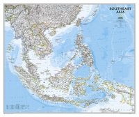
The Southeast Asia Political Map is a detailed reference map containing National Geographic’s clear visual presentation in a bright and appealing color palette. The map contains thousand of place names, accurate political boundaries, and infrastructure, making it the perfect reference for student, home, or business.   This detailed wall map of Southeast Asia by National Geographic includes Indonesia, New Guinea, the Phillipines, Malaysia, Thailand, Myanmar, Cambodia and Vietnam. Coverage includes the whole of Indonesia and the Philippines, and extends north to cover China as far as Hangzhou and, in the north-western corner, Bhutan.   Details featured on this Southeast Asia Wall Map include:   • Political Boundaries • Major Cities and Capitals • Physical Terrain Shading • Mountain Ranges, Highest Point • Lakes, Rivers and Waterways • Latitude and Longitude Lines • Basic Bathymetry (Ocean Depths) • Major Airports • National Parks
34,95
Wandkaart 20430 Afrika, politiek & antiek 61 x 78 cm | National Geographic
Mooie wandkaart van Afrika, staatkundig, met rustig kleurgebruik en helder kaartbeeld, Ondanks het wat kleiner formaat staan er toch heel wat topografische details op vermeld.    Kaart is up-to-date, alleen Zuid Sudan wordt niet als een apart land weergegeven.   Our executive-style political map of Africa features country boundaries, place names, bodies of water, airports, major highways and roads, and much more. Astounding detail and boardroom quality make this map excellent for reference in your home or office.   The map presents Africa at 1: 14,244,000 and coverage includes the whole of the Mediterranean Basin, extending north to London. Islands in the Atlantic and the Indian Ocean are included on a separate inset. The base map has relief shading to show the continent’s topography, with additional graphics indicating deserts, swamps, salt flats, etc. The map shows the names of the main geographic features such as mountain ranges, deserts, peaks etc. Heights are given in metres, …
24,95

Klanten-reviews van Wandkaart Europa, politiek, 114 x 88 cm

Er zijn nog geen beoordelingen voor dit productBen jij de eerste die een review plaatst?

Meer over Wandkaart Europa, politiek, 114 x 88 cm

Productomschrijving

This colorful Europe political map clearly shows country boundaries, capitals, many major cities, bodies of water, airports, major highways and roads, and much more.

Productinformatie

    Verken gerelateerde categorieën

    Webshop.nl maakt gebruik van cookies. Ga je verder op onze website, ga dan akkoord met het plaatsen van cookies en de verwerking van deze data door ons en vermelde partners.