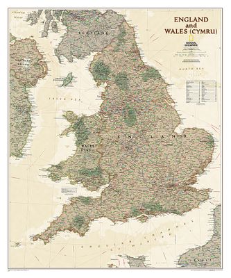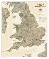
Wandkaart Engeland en Wales, antiek, 76 x 91 cm | National Geographic

0
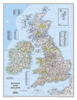
This earth-toned, executive-style map of England and Wales shows political boundaries, major highways and roads, cities and towns, airports, and other geographic details. Thousands of place-names and exact borders are carefully researched by National Geographic's map researchers and editors ensuring the utmost accuracy....

Verkopers met dit product

Webshop
Bezorging
Prijs
DeZwerver.nl logo
DeZwerver.nl
niet bekend
31,95

Anderen bekeken ook

Wereldkaart Politiek & antiek, pacific centered, 117 x 78 cm | National Geographic
National Geographic's World map is the standard by which all other reference maps are measured. The World map is meticulously researched and adheres to National Geographic's convention of making independent, apolitical decisions based on extensive research using multiple authoritative source.   The Executive style World map uses an antique-style color palette and stunning shaded relief that provide a richness perfect for any decor. The Pacific Centered World map employs a unique view to accentuate the Pacific Rim, and focuses on Oceania and Asia and while showing the entire breadth of the Pacific Ocean. Drawn in a special Winkel Tripel projection, distortions are minimized and unlike many other World maps, Greenland is show the same size as Argentina and not as the size of all of South America.   Thousands of place names are carefully and artistically placed on the map to maintain legibility even in the heavily populated ares of Europe, Asia and the Middle East. Details include clearl…
36,95
Wandkaart Afrika, politiek & antiek, 61 x 78 cm | National Geographic
Mooie wandkaart van Afrika, staatkundig, met rustig kleurgebruik en helder kaartbeeld, Ondanks het wat kleiner formaat staan er toch heel wat topografische details op vermeld.    Kaart is up-to-date, alleen Zuid Sudan wordt niet als een apart land weergegeven.   Our executive-style political map of Africa features country boundaries, place names, bodies of water, airports, major highways and roads, and much more. Astounding detail and boardroom quality make this map excellent for reference in your home or office.   The map presents Africa at 1: 14,244,000 and coverage includes the whole of the Mediterranean Basin, extending north to London. Islands in the Atlantic and the Indian Ocean are included on a separate inset. The base map has relief shading to show the continent’s topography, with additional graphics indicating deserts, swamps, salt flats, etc. The map shows the names of the main geographic features such as mountain ranges, deserts, peaks etc. Heights are given in metres, exc…
31,95
Wandkaart Scotland - Schotland, 76 x 91 cm | National Geographic
This new map of Scotland, features our rich, antique-inspired Executive style. This beautiful map includes thousands of place names, accurate political boundaries, national parks, archeological sites, and major infrastructure networks such as roads, canals, ferry routes, and railroads. Scotland’s diverse terrain is detailed through accurate shaded relief, coastal bathymetry, and symbolism for water features and other landforms.
31,95
Wandkaart New Zealand - Nieuw Zeeland 60 x 77 cm | National Geographic
Mooie heldere wandkaart van Nieuw Zeeland met het Noordereiland en Zuidereiland op dezelfde kant afgebeeld. Veel plaatsnamen, goed kleurgebruik waardoor hoogteverschillen en bijvoorbeeld nationale parken goed zichtbaar zijn.   The reference map of New Zealand uses National Geographic's signature Classic style with blue ocean and stunning shaded relief. The map shows this island nation in great detail, from the subtropical North Island (Te Ika-a-Maui) to the glacial carved valleys of Fiordland on the South Island (Te Waipounamu). The North Island is best known for large volcanic lakes and the cities of Auckland and Wellington. The South Island is famous for the Southern Alps that run along the spine of the island. The highest point in the country is Aoraki (Mount Cook) and is found in the Southern Alps.   The first settlers of New Zealand were the Maori from Polynesia, the names on the map reflect this history with both English and Maori variants. The map also features a transportation…
31,95
Wandkaart USA - Verenigde Staten Antiek, 111 x 77 cm | National Geographic
Wandkaart van de USA waarbij de kleuren in 'antieke' look zijn weergegeven, de staatgrenzen zeer duidelijk zijn en er veel plaatsen op staan.   This Antique-style USA Wall Map by National Geographic Maps combines classic antique-style cartography with fully updated geographical representation. Displaying elegant use of earth-tone color and extensive detail for type placement to aid readability, this USA map is loaded with information.   This USA wall map includes:   State Boundaries Capitals and Cities National Parks, Monuments and Recreation Areas Airports and Air Force Bases US Interstates and Highways Physical Terrain Shading Latitude and Longitude Graticule Insets of Hawaiian Islands and Alaska Legend and Abbreviation List Includes portions of Canada and Mexico
36,95

Klanten-reviews van Wandkaart Engeland en Wales, antiek, 76 x 91 cm | National Geographic

Er zijn nog geen beoordelingen voor dit productBen jij de eerste die een review plaatst?

Meer over Wandkaart Engeland en Wales, antiek, 76 x 91 cm | National Geographic

Productomschrijving

This earth-toned, executive-style map of England and Wales shows political boundaries, major highways and roads, cities and towns, airports, and other geographic details. Thousands of place-names and exact borders are carefully researched by National Geographic's map researchers and editors ensuring the utmost accuracy.

Verken gerelateerde categorieën

Webshop.nl maakt gebruik van cookies. Ga je verder op onze website, ga dan akkoord met het plaatsen van cookies en de verwerking van deze data door ons en vermelde partners.