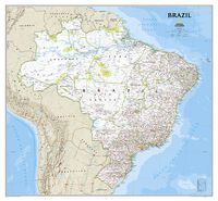
Wandkaart Brazil - Brazilië, 104 x 97 cm | National Geographic

0
National Geographic Wall Maps offer a special glimpse into current and historical events, and they inform about the world and environment. Offered in a variety of styles and formats, these maps are excellent reference tools and a perfect addition to any home, business or school. There are a variety of map options to choose from, including the worl...

Verkopers met dit product

Verkoper
Bezorging
Prijs
DeZwerver.nl logo
DeZwerver.nl
niet bekend
37,50

Anderen bekeken ook

Wandkaart 20611 Brazil - Brazilië, politiek & antiek, 104 x 97 cm | National Geographic
Presented in National Geographic’s classic wall map style, our large, earth-tone Brazil wall map is ideal for home or office. Inherent to all National Geographic reference cartography, this map contains thousands of place-names and accurate political boundaries including Brazil’s 26 states. Major and minor cities, superhighways, roads, passenger rail lines, and national parks are clearly depicted. Brazil’s diverse terrain is represented through accurate shaded relief and hydrographic symbology, elevations and depths are in meters.
34,95
Wandkaart Brazil - Brazillië Antiek, 104 x 97 cm | National Geographic
Presented in National Geographic’s classic wall map style, our large, earth-tone Brazil wall map is ideal for home or office. Inherent to all National Geographic reference cartography, this map contains thousands of place-names and accurate political boundaries including Brazil’s 26 states. Major and minor cities, superhighways, roads, passenger rail lines, and national parks are clearly depicted. Brazil’s diverse terrain is represented through accurate shaded relief and hydrographic symbology, elevations and depths are in meters.
45,95
Wandkaart Scandinavië en Ijsland, 60 x 77 cm | National Geographic
National Geographic Wall Maps offer a special glimpse into current and historical events, and they inform about the world and environment. Offered in a variety of styles and formats, these maps are excellent reference tools and a perfect addition to any home, business or school. There are a variety of map options to choose from, including the world, continents, countries and regions, the United States, history, nature and space.
31,95
Wandkaart Holy Land - Israël, 53 x 80 cm | National Geographic
National Geographic Wall Maps offer a special glimpse into current and historical events, and they inform about the world and environment. Offered in a variety of styles and formats, these maps are excellent reference tools and a perfect addition to any home, business or school. There are a variety of map options to choose from, including the world, continents, countries and regions, the United States, history, nature and space.
31,95
Wandkaart 20044 Holy Land - Israël, 53 x 80 cm | National Geographic
National Geographic Wall Maps offer a special glimpse into current and historical events, and they inform about the world and environment. Offered in a variety of styles and formats, these maps are excellent reference tools and a perfect addition to any home, business or school. There are a variety of map options to choose from, including the world, continents, countries and regions, the United States, history, nature and space.
25,95
Wegenkaart - landkaart 3404 Adventure Map Peru | National Geographic
Wegenkaart van Peru met vermelding van veel bezienswaardigheden, nationale parken en attrakties. Watervast en scheurvast. Juist door deze vermeldingen onderscheidt de kaart zich van andere wegenkaarten. National Geographic's Peru Adventure Map is designed to meet the unique needs of adventure travelers—detailed, durable, and accurate. Peru includes the locations of thousands of towns and villages, plus a clearly marked road network complete with distances and designations for highways and roadways. Rough tracks that require four-wheel drive vehicles and paths are included for adventurers seeking to explore more remote regions.   What sets National Geographic Adventure Maps apart from traditional road maps are the hundreds of points of interest that highlight the diverse, unique, and exotic destinations within Peru including World Heritage sites, archeological sites, indigenous areas, churches, museums, and more. Users will find a variety of helpful travel aids on our map as well, incl…
17,50
Wandkaart Middle East - Midden Oosten 76 x 58 cm | National Geographic
Wandkaart van het Midden Oosten, met o.a. Afghanistan - Pakistan - National Geographic wandkaart geplastificeerd - Afmeting ca 76 x 58 cm  National Geographic Maps' recently updated wall map of the Middle East region, formerly titled Afghanistan/Pakistan and the Middle East. Includes updated place names and the addition of significant locations currently in the news, such as Marjah, Afghanistan. This wall map covers a broad geographic area ranging from northern Africa through the Middle East to the western edge of China and India.   Includes complete coverage of Afghanistan, Pakistan, Tajikistan, Iran, Iraq, Kuwait, Syria, Israel, Jordan, Lebanon, Saudi Arabia, Qatar, Bahrain, United Arab Emirates, Yemen, Oman, Cyprus, and Eritrea.   Also includes parts of India, China, Kyrgyzstan, Uzbekistan, Turkmenistan, Azerbaijan, Armenia, Turkey, Egypt, Sudan, Ethiopia, and Djibouti. Features thousands of place names, accurate political boundaries, archeological sites, and major infrastructure n…
31,95
Wegenkaart - landkaart 3401 Adventure Map Brazil - Brazilië | National Geographic
Wegenkaart van Brazilië met vermelding van veel bezienswaardigheden, nationale parken en attrakties. Watervast en scheurvast. Juist door deze vermeldingen onderscheidt de kaart zich van andere wegenkaarten. National Geographic s Brazil AdventureMap is designed to meet the unique needs of adventure travelers detailed, durable, and accurate. Brazil includes the locations of thousands of major cities and towns with an index for easily locating them, plus a clearly marked road network complete with distances and designations for major highways, limited access highways, tollways, and more.    What sets National Geographic AdventureMaps apart from traditional road maps are the hundreds of points-of-interest that highlight the diverse, unique, and exotic destinations within Brazil including national parks and reserves, World Heritage sites, archeological sites, indigenous areas, churches, zoos, and museums.    The front side of the Brazil map includes the western half of the country and feat…
17,50
Wandelkaart 901 Banff North National Park | National Geographic
Prachtige geplastificeerde kaart van het bekende nationaal park. Met alle recreatieve voorzieningen als campsites, maar ook met topografische details en wandelroutes ed. Door uitgekiend kleurgebruik zeer prettig in gebruik. Scheur en watervast! The front side of the Banff North map details the south side of the national park, from Siffleur Wilderness Area to the north, to Kootenay National Park to the south. This side also covers survival tips, area trails, entry fees and details both Kootenay and Yoho Nationals Parks. The reverse side of the map details the north side of the park, extending from Siffleur Wilderness area to the south, to White Goat Wilderness to the North. Insets show safe travel in Bear Country, and all the recreation the park has to offer with backpacking, camping, biking, hiking and horseback riding.  National Geographic's Trails Illustrated map of Banff North is a two-sided, waterproof map designed to meet the needs of outdoor enthusiasts with unmatched durability…
17,95
Wandkaart Caribbean - Caraïben, 91 x 61 cm | National Geographic
Completely redesigned and updated, National Geographic Maps' Caribbean Classic wall map is one of the most authoritative maps for the islands of the Caribbean Sea. This new edition shows the entire region in exceptional detail, with coverage extending from the tip of Florida to the northern extents of Colombia and Venezuela, east to Barbados, and west to the eastern edge of Honduras, Costa Rica, and Nicaragua. Updated bathymetry reveals the remarkable seafloor variation of the Caribbean including the Puerto Rico Trench, the deepest point in the Atlantic Ocean at 8,605 meters (28,232 feet).   Caribbean Classic is a perfect tool for business or education reference, and a beautiful addition to any décor. Shown on the map are over 1,000 named places including country capitals, primary and secondary towns; political boundaries, important infrastructure, and all key landforms. Useful and informative notes about the region's history and unique geography are spread throughout the map, providi…
32,95

Klanten-reviews van Wandkaart Brazil - Brazilië, 104 x 97 cm | National Geographic

Er zijn nog geen beoordelingen voor dit productBen jij de eerste die een review plaatst?

Meer over Wandkaart Brazil - Brazilië, 104 x 97 cm | National Geographic

Productomschrijving

National Geographic Wall Maps offer a special glimpse into current and historical events, and they inform about the world and environment. Offered in a variety of styles and formats, these maps are excellent reference tools and a perfect addition to any home, business or school. There are a variety of map options to choose from, including the world, continents, countries and regions, the United States, history, nature and space.

This wall map of Brazil contains thousands of place names and accurate political boundaries including Brazil's 26 states. Major and minor cities, superhighways, roads, passenger rail lines, and national parks are clearly depicted. Brazil's diverse terrain is represented through accurate shaded relief and hydrographic symbology. Elevations and depths are in meters.

Verken gerelateerde categorieën

Webshop.nl maakt gebruik van cookies. Ga je verder op onze website, ga dan akkoord met het plaatsen van cookies en de verwerking van deze data door ons en vermelde partners.