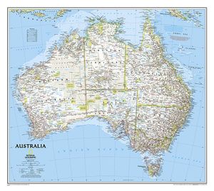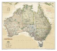
Wandkaart Australië, politiek, 77 x 69 cm | National Geographic

0
Highly accurate Australia political map clearly shows state boundaries, place names, bodies of water, parks and preserves, and more. Includes inset maps for Tasmania and major Australian cities. This version is laminated—featuring a "write and wipe" surface and durable plastic covering....

Verkopers met dit product

Webshop
Bezorging
Prijs
DeZwerver.nl logo
DeZwerver.nl
niet bekend
31,95

Anderen bekeken ook

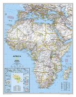
Wandkaart Afrika, politiek & antiek, 61 x 78 cm | National Geographic
Mooie wandkaart van Afrika, staatkundig, met rustig kleurgebruik en helder kaartbeeld, Ondanks het wat kleiner formaat staan er toch heel wat topografische details op vermeld.    Kaart is up-to-date, alleen Zuid Sudan wordt niet als een apart land weergegeven.   Our executive-style political map of Africa features country boundaries, place names, bodies of water, airports, major highways and roads, and much more. Astounding detail and boardroom quality make this map excellent for reference in your home or office.   The map presents Africa at 1: 14,244,000 and coverage includes the whole of the Mediterranean Basin, extending north to London. Islands in the Atlantic and the Indian Ocean are included on a separate inset. The base map has relief shading to show the continent’s topography, with additional graphics indicating deserts, swamps, salt flats, etc. The map shows the names of the main geographic features such as mountain ranges, deserts, peaks etc. Heights are given in metres, exc…
31,95
Wandkaart - Prikbord Australasia - Australië, Nieuw Zeeland en deel Oceanië, 120 x 100 cm | Maps International
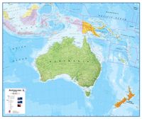
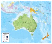
Fraaie politieke kaart van het continent, waarbij vooral de politieke aspecten heel duidelijk te lezen zijn. Alle landen hebben verschillende kleuren, steden en belangrijke verbindingen zijn goed te vinden.   De wandkaarten op prikbord worden geleverd met een aluminium lijst en een eenvoudig te monteren ophangsysteem. Zij zijn geschikt voor allerhande markeringsystemen als vlaggetjes en prikkers.   Maps International's Australasia political wall map shows Papua New Guinea in the North of the continent down to Tasmania and New Zealand in the south.   This political wall map of Australasia features countries marked in different colours, with international borders clearly shown. The map's key shows the flags from the countries displayed in this map (Australia, New Zealand and Papua New Guinea). This political wall map of Australasia also contains city population detail, capital cities and all the major towns and cities in this continent.   Maps International's Asia map is available eithe…
185,-
Wandkaart - Magneetbord Australasia - Australië, Nieuw Zeeland en deel Oceanië, 120 x 100 cm | Maps International
Fraaie politieke kaart van het continent, waarbij vooral de politieke aspecten heel duidelijk te lezen zijn. Alle landen hebben verschillende kleuren, steden en belangrijke verbindingen zijn goed te vinden.   De kaart wordt in deze versie gelijmd op een plaat, voorzien van een mooie aluminium lijst en een ophangsysteem wordt meegeleverd. Daarnaast krijgt u een bakje bijgeleverd dat u er aan kunt bevestigen voor pennen, stiften of magneetjes.   Maps International's Australasia political wall map shows Papua New Guinea in the North of the continent down to Tasmania and New Zealand in the south.   This political wall map of Australasia features countries marked in different colours, with international borders clearly shown. The map's key shows the flags from the countries displayed in this map (Australia, New Zealand and Papua New Guinea). This political wall map of Australasia also contains city population detail, capital cities and all the major towns and cities in this continent.   Ma…
269,-
Wandkaart Afrika, politiek, 91 x 118 cm | National Geographic
Mooie wandkaart van Afrika, staatkundig, met rustig kleurgebruik en helder kaartbeeld, Ondanks het wat kleiner formaat staan er toch heel wat topografische details op vermeld.    The map presents Africa at 1: 9.328.000 and coverage includes the whole of the Mediterranean Basin, extending north to London. Islands in the Atlantic and the Indian Ocean are included on a separate inset. The base map has relief shading to show the continent’s topography, with additional graphics indicating deserts, swamps, salt flats, etc. The map shows the names of the main geographic features such as mountain ranges, deserts, peaks etc. Heights are given in metres, except for Kilimanjaro, shown in both metres and feet. In the Congo basin many of the tributaries are named.    Country boundaries are shown in contrasting colours. All place names are in English, except for selected cities such as Cairo, Tripoli or Algiers where the original names are shown first (El Quahira, etc) with the English equivalents …
45,95
Wandkaart Afrika, politiek, 61 x 78 cm | National Geographic
Mooie wandkaart van Afrika, staatkundig, met rustig kleurgebruik en helder kaartbeeld, Ondanks het wat kleiner formaat staan er toch heel wat topografische details op vermeld.    Kaart is up-to-date, alleen Zuid Sudan wordt niet als een apart land weergegeven.   The map presents Africa at 1: 14,244,000 and coverage includes the whole of the Mediterranean Basin, extending north to London. Islands in the Atlantic and the Indian Ocean are included on a separate inset. The base map has relief shading to show the continent’s topography, with additional graphics indicating deserts, swamps, salt flats, etc. The map shows the names of the main geographic features such as mountain ranges, deserts, peaks etc. Heights are given in metres, except for Kilimanjaro, shown in both metres and feet. In the Congo basin many of the tributaries are named.    Country boundaries are shown in contrasting colours. All place names are in English, except for selected cities such as Cairo, Tripoli or Algiers whe…
31,95
Wandkaart Afrika, politiek, 91 x 118 cm | National Geographic
Mooie wandkaart van Afrika, staatkundig, met rustig kleurgebruik en helder kaartbeeld, Ondanks het wat kleiner formaat staan er toch heel wat topografische details op vermeld.    The map presents Africa at 1: 9.328.000 and coverage includes the whole of the Mediterranean Basin, extending north to London. Islands in the Atlantic and the Indian Ocean are included on a separate inset. The base map has relief shading to show the continent’s topography, with additional graphics indicating deserts, swamps, salt flats, etc. The map shows the names of the main geographic features such as mountain ranges, deserts, peaks etc. Heights are given in metres, except for Kilimanjaro, shown in both metres and feet. In the Congo basin many of the tributaries are named.    Country boundaries are shown in contrasting colours. All place names are in English, except for selected cities such as Cairo, Tripoli or Algiers where the original names are shown first (El Quahira, etc) with the English equivalents …
99,50
Wegenkaart - landkaart Australia and Oceania | National Geographic
• Waterproof • Tear-Resistant • Reference Map   Expertly researched and designed, National Geographic's Australia and Oceania Flags & Facts Map is the authoritative map of Australia by which other reference maps are measured. The map side includeds a political map showing countries, cities and other landmarks and a physical map shows the landforms such as mountain ranges and rivers. The Flags & Facts side includes an overview map of Oceania, the section of the Pacific Ocean stretching from New Zealand to the Galapagos Islands.   Clearly defined boundaries, major cities, and physical features Hundreds of place names carefully placed to maintain legibility in heavily populated areas Includes Australia and Oceania and adjacent regions of Asia Detailed physical map of Australia with mountain ranges, plains, lakes, and rivers Flags and facts with detailed information about cultural and physcial attributes Printed in the U.S.A. on extremely durable, waterproof, and tear-resistant material T…
17,50

Klanten-reviews van Wandkaart Australië, politiek, 77 x 69 cm | National Geographic

Er zijn nog geen beoordelingen voor dit productBen jij de eerste die een review plaatst?

Meer over Wandkaart Australië, politiek, 77 x 69 cm | National Geographic

Productomschrijving

Highly accurate Australia political map clearly shows state boundaries, place names, bodies of water, parks and preserves, and more. Includes inset maps for Tasmania and major Australian cities. This version is laminated—featuring a "write and wipe" surface and durable plastic covering.

Verken gerelateerde categorieën

Webshop.nl maakt gebruik van cookies. Ga je verder op onze website, ga dan akkoord met het plaatsen van cookies en de verwerking van deze data door ons en vermelde partners.