Wandelkaart Yorkshire Dales Noord West | Harvey Maps

0
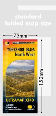
Covers a large area yet is handily compact. Pocket perfect!   Detailed map for runners and walkers of the north western part of the Yorkshire Dales National Park at the magic scale of 1:40,000.   Features the Howgill Fells, the Calf, Cautley Crag, and Wild Boar Fell. Includes Sedbergh, Hawes and Kirkby Stephen....

Verkopers met dit product

Verkoper
Bezorging
Prijs
DeZwerver.nl logo
DeZwerver.nl
2,95
20,95

Anderen bekeken ook

Wandelkaart Yorkshire Dales Zuid West | Harvey Maps
HARVEY launch innovative new series: Ultramap XT40. 16 titles featuring in Trail magazine through spring 2016. 40 years experience have gone into HARVEY's most creative new series. The Ultramap covers a large area yet is small enough to slip in a pocket. The Ultramap is fully detailed genuine original HARVEY mapping. The Ultramap is tough and 100% waterproof. Use it without a map case, whatever the weather! To provide the biggest area on the smallest lightest sheet, the Ultramap is printed double sided. The ingenious folding pattern allows you to open the Ultramap directly to any part and either side of the sheet. The two sides are aligned, so when you reach the edge of the Ultramap sheet you simply flip it over without re-folding. There's an overlap as well so you can map read continuously. The magic scale of 1:40,000 enables the Ultramap to provide all the detail you would expect to find on a large scale walking map including rights of way and boundaries. Actual size 73mm x 152mm. P…
20,95
Wandelgids 15 Short Walks Yorkshire Dales | Cicerone
Discover 15 of the best short walks around Sedbergh, Kirkby Lonsdale and Ingleton. Each walk comes with easy-to-read Ordnance Survey maps, clear route description and lots of images, plus information on beauty spots and refreshment stops. No challenging terrain or complicated navigation means everyone can enjoy walks.   Seasons These routes are suitable for walking at all times of the year, although in winter and extremely wet weather, extra care will be needed on steep slopes and near rivers and waterfalls. Centres Sedbergh and Kirkby Lonsdale are the main centres. The villages of Dent and Barbon also provide a range of more limited facilities. Difficulty The Yorkshire Dales comprise dales (valleys) but also steep hillsides from where extensive views can be enjoyed. Stoney tracks and paths tend to be the norm, rivers and streams are crossed on footbridges, and narrow ‘squeeze’ stiles pass through drystone walls. Must See Sedbergh, Kirkby Lonsdale, Dent, Barbon, Barbondale, Dentdale, …
18,95
Wandelkaart Yorkshire Dales Zuid Oost | Harvey Maps
HARVEY launch innovative new series: Ultramap XT40. 16 titles featuring in Trail magazine through spring 2016. 40 years experience have gone into HARVEY's most creative new series. The Ultramap covers a large area yet is small enough to slip in a pocket. The Ultramap is fully detailed genuine original HARVEY mapping. The Ultramap is tough and 100% waterproof. Use it without a map case, whatever the weather! To provide the biggest area on the smallest lightest sheet, the Ultramap is printed double sided. The ingenious folding pattern allows you to open the Ultramap directly to any part and either side of the sheet. The two sides are aligned, so when you reach the edge of the Ultramap sheet you simply flip it over without re-folding. There's an overlap as well so you can map read continuously. The magic scale of 1:40,000 enables the Ultramap to provide all the detail you would expect to find on a large scale walking map including rights of way and boundaries. Actual size 73mm x 152mm. P…
20,95

Klanten-reviews van Wandelkaart Yorkshire Dales Noord West | Harvey Maps

Er zijn nog geen beoordelingen voor dit productBen jij de eerste die een review plaatst?

Meer over Wandelkaart Yorkshire Dales Noord West | Harvey Maps

Productomschrijving

Covers a large area yet is handily compact. Pocket perfect!   Detailed map for runners and walkers of the north western part of the Yorkshire Dales National Park at the magic scale of 1:40,000.   Features the Howgill Fells, the Calf, Cautley Crag, and Wild Boar Fell. Includes Sedbergh, Hawes and Kirkby Stephen.

Productinformatie

    Verken gerelateerde categorieën

    Webshop.nl maakt gebruik van cookies. Ga je verder op onze website, ga dan akkoord met het plaatsen van cookies en de verwerking van deze data door ons en vermelde partners.