Wandelkaart Yorkshire Dales Noord-West | Harvey Maps

0
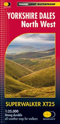
The Yorkshire Dales National Park on just 4 sheets. Yorkshire Dales North West: The coverage of this map includes The Howgill Fells, upper Wensleydale and upper Swaledale. Genuine original HARVEY mapping at 1:25,000, Clear, easy to read, Easy to re-fold Opens directly to either side of the sheet, Slim and flexible, light to carry, Tearproof and du...

Verkopers met dit product

Verkoper
Bezorging
Prijs
DeZwerver.nl logo
DeZwerver.nl
2,95
24,95

Anderen bekeken ook

Wandelgids Yorkshire Dales | Ordnance Survey
Enjoy the magnificent waterfalls, sweeping scenery and cosy Dale pubs with ten short, leisurely walks suitable for all ages and abilities. Discover the Yorkshire Dales with its natural wonders, lush wildlife and quaint villages on accessible, tried-and-tested walks which everyone can go on – no walking experience required.   Yorkshire Dales Short Walks Made Easy include:   - Walk the banks of the River Eden through Westmorland and explore the limestone scenery around Kirkby Stephen - See some of the iconic waterfalls for which the Yorkshire Dales are famous in Upper Swaledale on a walk to East Gill Force and Kisdon Force - Discover Heriot Country around the village of Askrigg, surrounded by wildflower meadows - See the iconic Ribblehead Viaduct on a moorland walk in the shadow of Whernside, Yorkshire’s highest hill - Follow the River Wharfe through wildflower meadows through Grassington - Take in unmissable Malham Cove, one of England’s most spectacular natural features   OS Short Wal…
10,95
Wandelgids The Yorkshire Dales - Walking in the North and East | Cicerone
This guidebook contains 43 circular day walks in the north and east Yorkshire Dales. It explores the dales, hills and moors between Kirkby Stephen and Pateley Bridge. Walking ranges from gentle three-mile strolls to more strenuous day-long rambles across the Howgills, Wensleydale, Swaledale, Nidderdale, Mallerstang and Coverdale   In this guidebook, 43 circular walks, ranging from 3-mile strolls to full-day adventures are explored in the northern and eastern Dales. Few areas in England are as appealing as the Yorkshire Dales and this volume of a two-part guide provides walkers with a comprehensive walking guide to the whole of the region.     Each valley has a character and history of its own and this guide covers the varied fell and dale landscapes of the Howgills, Mallerstang, Swaledale, Wensleydale, Coverdale and Nidderdale. Spectacular waterfalls, dramatic gorges, expansive heather moors, rich woodlands and colourful flower meadows are just some of the natural delights encountered…
19,95
Wandelkaart The Dales Way | Footprint maps
Handzame wandelkaart voor de Dales Way in Noord Engeland.  The Dales Way is a 79 mile (127km) long distance trail in the north of England, running between Ilkley, in North Yorkshire and Bowness-on-Windermere, in Cumbria. Much of the route passes through the Yorkshire Dales and Lake District National Parks. Starting out in Ilkley, the route runs along Wharfedale, passing the impressive ruins of Bolton Priory and the attractive market town of Grassington. It continues along the River Wharfe through dramatic limestone scenery before it crosses The Pennines to reach Dentdale and Sedbergh. It then skirts the Howgill Fells and crosses the M6 motorway to finish overlooking Lake Windermere.   This map-guide is laid out for walkers travelling from Ilkley to Bowness, although walkers travelling in the opposite direction should find it equally useful. Each panel includes a detailed route map, route profile and helpful notes on navigation.   There are link routes from Bradford, Leeds and Harrogat…
12,95

Klanten-reviews van Wandelkaart Yorkshire Dales Noord-West | Harvey Maps

Er zijn nog geen beoordelingen voor dit productBen jij de eerste die een review plaatst?

Meer over Wandelkaart Yorkshire Dales Noord-West | Harvey Maps

Productomschrijving

The Yorkshire Dales National Park on just 4 sheets. Yorkshire Dales North West: The coverage of this map includes The Howgill Fells, upper Wensleydale and upper Swaledale. Genuine original HARVEY mapping at 1:25,000, Clear, easy to read, Easy to re-fold Opens directly to either side of the sheet, Slim and flexible, light to carry, Tearproof and durable AND 100% waterproof as standard - no need for a map case.

Verken gerelateerde categorieën

Webshop.nl maakt gebruik van cookies. Ga je verder op onze website, ga dan akkoord met het plaatsen van cookies en de verwerking van deze data door ons en vermelde partners.