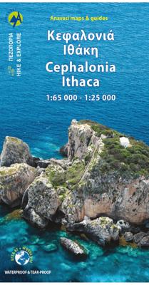


Wandelkaart - Wegenkaart - landkaart 9.3 Kefalonia - Ithaca | Anavasi

0
Kefalonia staat bekend om haar prachtige stranden. Het eiland heeft grote bergen en ongerepte gebieden die het een ideale bestemming maken voor wandeltochten. Alle afgebeelde paden zijn in de afgelopen twee jaar opgenomen. De kaart is dubbelzijdig met Kefalonia op een schaal van 1: 65.000 aan de ene kant en Ithaca op een schaal van 1: 25.000 aan d...

Alle aanbiedingen van dit product

Verkoper
Bezorging
Prijs
DeZwerver.nl logo
DeZwerver.nl
2,95
10,95

Anderen bekeken ook

Wandelkaart - Wegenkaart - landkaart 9.3 Kefalonia - Ithaca | Anavasi
Kefalonia staat bekend om haar prachtige stranden. Het eiland heeft grote bergen en ongerepte gebieden die het een ideale bestemming maken voor wandeltochten. Alle afgebeelde paden zijn in de afgelopen twee jaar opgenomen. De kaart is dubbelzijdig met Kefalonia op een schaal van 1: 65.000 aan de ene kant en Ithaca op een schaal van 1: 25.000 aan de andere kant. De kaarten van Anavasi zijn zeer gedetailleerd, beschikken over een helder kaartbeeld en zijn uitstekende kaarten voor diverse activiteiten. Ze beschikken over vele interessante punten voor wandelaars, fietsers of andere toeristen die het gebied bezichtigen. De wandelkaarten bevatten ook een uitzonderlijke reliefaanwijzing, verschillende vormen van gewassen en andere topografische details. Inclusief hoogtelijnen, wandelpaden, toeristische informatie en UTM grid, de kaart is geschikt voor gebruik met GPS.
10,95
Wegenkaart - landkaart 304 Kefalonia - Ithaca | Road Editions
Goede overzichtskaart  van Kefalonia. Als wandelkaart iets minder, dan is de Anavasi beter. From Road Editions-probably the best range of maps available to cover Greece. Road Editions constantly update their data and mapping. This map of Kefalonia and Ithaca shows the Islands with unique accuracy, with data produced using the industrys most advanced techniques. The complete road networks of Kefalonia and Ithaca are shown, including forest roads, and with scenic routes shown in green. Contour lines-with coloured shading which darkens with increasing altitude-give an at-a-glance guide to the terrain. Also plenty of information such as churches gorges, peaks, caves, beaches, springs etc. Accurate distances of roads are printed midway between crossroads, and locations of refuelling sites are shown too. Streetmapping for Argostoli and Lixouri are inset at the top of the sheet. Reverse holds a list of hotels on both islands with their class, telephone/fax numbers, along with lots of tourist…
9,95
Wandelkaart - Wegenkaart - landkaart Kefallonia - Kefalonia | Freytag & Berndt
Goede wegenkaart van Kefallonia / Kefalonia, waarbij ook de kleinere wegen nog goed te lezen zijn. Gedetailleerde schaal van 1:50.000. Veel toeristische symbolen voor bezienswaardigheden als grotten, tempels, opgravingen maar ook mooie stranden etc. Ook handig is de Nederlandstalige Reisgids van Kefalonia "Ontdek Kefalonia" "Ontdek Kefalonia" Explore Kefallonia, the largest of the Ionian Islands located in Greece; with this Freytag & Berndt single-sided road and leisure map. The map will allow you to travel independently, and plan your journey well.   The map also features full colour photographs of some of the scenery to be found on Kefallonia, as well as an inset showing Kefallonia's position within the nation of Greece. An inset is also provided showing a city plan of the main township on Kefallonia, Argostoli. The topography is clear, with shading showing land gradients.    As with all Freytag & Berndt maps, icons and markings are used to denote tourist information and points of i…
14,95
Reisgids Ontdek Kefalonia & Ithaka | Reithron
De enige Nederlandstalige reisgids van Kefalonia en Ithaka. Met bezienswaardigheden, accommodaties, eten en drinken en achtergronden. Veel illustraties geven je een goed idee van het eiland. Geschreven door een inwoner van Kefalonia ... de vrouw van een burgemeester! Ontdek Kefalonia en Ithaka van Hettie Metaxas-Putman Cramer Reithron Editions is een Nederlandstalige reisgids over het Ionische eilanden Kefalonia (Cephalonia) en Ithaca met informatie over toeristische bezienswaardigheden, achtergrondinformatie en geschiedenis, excursies op het eiland en beschrijvingen van wandelingen, flora en fauna en de mooiste stranden, waaronder Mirtos beach, dat bekend staat als het fraaiste strand van Griekenland. Verder eenvoudige kaarten en mooie kleurenfoto's. Ook handig is de Wegenkaart van Kefallonia
19,95
Reisgids Kefalonia & Ithaka | Michael Müller Verlag
Uitstekende, diepgaande reisgids over Kefalonia & Ithaka. Met veel achtergrondinformatie en ook praktische zaken als overnachtingen en eet- en drinkgelegenheden. Anders reisen und dabei das Besondere entdecken Mit den aktuellen Tipps aus den Michael-Müller-Reiseführern gestalten Sie Ihre Reise individuell, nachhaltig und sicher.   Entdecken Sie Griechenland und wandeln Sie mit Sabine Becht und Sven Talaron auf den Spuren von Odysseus. Auf 272 Seiten mit 182 Farbfotos zeigen Ihnen unsere Autoren die prächtige Vielfalt der Ionischen Inseln Íthaka (Heimat des homerischen Helden Odysseus) und Kefaloniá, der größeren Nachbarinsel. Die Insel Kefaloniá bietet neben ihren ganz eigenen Naturwundern auch einen der schönsten Strände Griechenlands. Weitere traumhafte Strände in Türkis und Weiß, faszinierende Unterwelten, abgelegene Hafenidylle und versteckte zauberhafte Badebuchten – dank der 25 Karten und Pläne im Buch finden Sie sich auf Ihrer Reise so gut zurecht, wie die Einheimischen.   Nebe…
22,50
Wandelkaart - Wegenkaart - landkaart 10.28 Naxos | Anavasi
Zeer goede kaart van Naxos. Topografische details zijn goed uitgewerkt, zeer leesbare kaart met ook nog eens alle toeristisch interessante punten.   The few and relatively recent asphalt roads on Naxos have not been laid over the old network of byways, leaving much of it intact for visitors to use. The footpaths are well - marked and one can travel the whole island on foot.   Many paths are added to this new edition of the very detailed maps of Naxos and the 5 Small Cyclades (Irakleia, Schinousa, Pano Koufonisi, Kato Koufonisi and Donousa). Several proposed hiking routes and the course of Naxos Trail
10,95
Wandelkaart - Wegenkaart - landkaart 10.30 Tinos | Anavasi
Goede wandelkaart van Tinos. Tinos island landscape is like a hand made embroidery. Rural huts, dovecotes, churches, terraces and villages are woven into a net of trails. In the first edition of the map, along with my partner Charles Merlin we had recorded several dozens of kilometers of footpaths. From then until the present second edition, Charles made a bet and target to enrich the map in paths, - and put in the game and his friend George Kennedy. Actually the recorded paths, doubled, and plenty of churches, bridges, huts, dovecotes were added beside the paths. Along with the improvements in topographic background and color palette, the map of Tinos has reached very high standards - because we don't like the easy path. On the back side there are several proposed hiking trails with short descriptions and updated information for marking of the paths.
10,95
Wandelkaart - Wegenkaart - landkaart 10.24 Santorini | Anavasi
As you enter the caldera of Santorini by ferry sheer cliffs rise up dramatically, exposing richly coloured rock strata, crowned by the colored houses of the cliff-top settlements. Equally magnificent is the sunset from the heights of the caldera towards the sea and the remnants of prehistoric rounded island Strogyli, Thirasia, the New and Old Kameni. However, there is more than the visual excitement to discover and if you don’t take the time to walk the island you will have learnt little of Santorini.   The new Anavasi map will take hiking in every corner, beach and hill top of Santorini and Thirassia to discover landscapes with visible signs of the traditional rural culture, with orchards stonewalls, threshing floors, huts, chapels, inland villages with a well preserved medieval core (called Castelo), routes with wonderful vistas, lost beaches quiet even in the heart of summer.   On the reverse side of the map, there is a brief description of the 25 proposed hiking routes and a short…
10,95
Wandelkaart - Wegenkaart - landkaart 10.51 Ikaria | Anavasi
The new Anavasi map of Ikaria on a scale of 1:35.000 figures dozens of footpaths, the complete road network and all the beaches of the island, which is also well known for its summer feasts (panigiria) and the longevity of its inhabitants. The island was named after the mythical Icarus, the young man who flew too close to the sun and plunged into the sea, close to Ikaria.   Ikaria has a well-marked network of hiking trails. The island is indeed perfect for days of hiking pleasure with lots of vegetation, deep river valleys with plenty of hidden, refreshingly cold (and clean) water pools, relatively level top plateaus and a ridge line that climbs up to about 900-1000m above sea level with amazing views and nice beaches to end the walks. Printing on waterproof, rip-proof polyart paper
10,95

Klanten-reviews van Wandelkaart - Wegenkaart - landkaart 9.3 Kefalonia - Ithaca | Anavasi

Er zijn nog geen beoordelingen voor dit productBen jij de eerste die een review plaatst?

Meer over Wandelkaart - Wegenkaart - landkaart 9.3 Kefalonia - Ithaca | Anavasi

Productomschrijving

Kefalonia staat bekend om haar prachtige stranden. Het eiland heeft grote bergen en ongerepte gebieden die het een ideale bestemming maken voor wandeltochten. Alle afgebeelde paden zijn in de afgelopen twee jaar opgenomen. De kaart is dubbelzijdig met Kefalonia op een schaal van 1: 65.000 aan de ene kant en Ithaca op een schaal van 1: 25.000 aan de andere kant.

De kaarten van Anavasi zijn zeer gedetailleerd, beschikken over een helder kaartbeeld en zijn uitstekende kaarten voor diverse activiteiten. Ze beschikken over vele interessante punten voor wandelaars, fietsers of andere toeristen die het gebied bezichtigen. De wandelkaarten bevatten ook een uitzonderlijke reliefaanwijzing, verschillende vormen van gewassen en andere topografische details. Inclusief hoogtelijnen, wandelpaden, toeristische informatie en UTM grid, de kaart is geschikt voor gebruik met GPS.

Productinformatie

    Verken gerelateerde categorieën

    Webshop.nl maakt gebruik van cookies. Ga je verder op onze website, ga dan akkoord met het plaatsen van cookies en de verwerking van deze data door ons en vermelde partners.