webshop.nl
Categorieën
  Sluiten

Meer Terrain maps

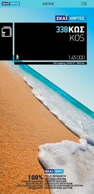
Wandelkaart - Wegenkaart - landkaart 338 Kos | Terrain maps

0
Gedetailleerde wegenkaart en wandelkaart met alle kleine wegen, wandelpaden, hoogtelijnen en toeristische informatie aangegeven. Alle tekst is tweetalig in Engels en Grieks en de waterproof kaart is geschikt voor gebruik met GPS. This is a great map because: It is the first GIS map of the island, meaning that this is the first time Kos is mapped w...

Webshops met dit product

Webshop
Bezorging
Prijs

Anderen bekeken ook

Wandelkaart - Wegenkaart - landkaart 338 Kos | Terrain maps
Gedetailleerde wegenkaart en wandelkaart met alle kleine wegen, wandelpaden, hoogtelijnen en toeristische informatie aangegeven. Alle tekst is tweetalig in Engels en Grieks en de waterproof kaart is geschikt voor gebruik met GPS. This is a great map because: It is the first GIS map of the island, meaning that this is the first time Kos is mapped with a topographic precision in proportion to the map scale.  The road network of Kos is featured so completely for the first time. Every road, down to the secondary dirt roads and dead-ends, is illustrated on the map with precision. Naturally the main road network is clearly depicted, along with residential areas, the airport, the ports and the entire tourist infrastructure of Kos.  It is waterproof and rip-proof. You can fold and unfold it a thousand times, fold it in irregular ways, dunk it in the sea or leave it out in the rain. This map is indestructible!  It is remarkably detailed, as its scale is much larger (i.e. more detailed) than…
12,50
Wandelkaart - Wegenkaart - landkaart 336 Leros | Terrain maps
Gedetailleerde wegenkaart en wandelkaart met alle kleine wegen, wandelpaden, hoogtelijnen en toeristische informatie aangegeven. Alle tekst is tweetalig in Engels en Grieks en de waterproof kaart is geschikt voor gebruik met GPS. THIS IS THE BEST MAP OF LEROS BECAUSE:  •    It is the first GIS map of the island, meaning that this is the first time Leros is mapped with a topographic precision in proportion to the map scale.    •    It is waterproof and rip-proof. You can fold and unfold it a thousand times, fold it in irregular ways, dunk it in the sea or leave it out in the rain. This map is indestructible!    •    It is the first time the island’s entire coastline is mapped. Cartography was done with TERRAIN’s specially equipped and staffed cartographic vessel. This means that you can locate all beaches of the island, down to the tiniest cove! In fact, the special features of every single beach are recorded: whether it is sandy or pebbled, whether it features natural tree shade, water…
12,50
Wandelkaart - Wegenkaart - landkaart 308 Tinos | Terrain maps
Gedetailleerde wegenkaart en wandelkaart met alle kleine wegen, wandelpaden, hoogtelijnen en toeristische informatie aangegeven. Alle tekst is tweetalig in Engels en Grieks en de waterproof kaart is geschikt voor gebruik met GPS. This is a great map of Tinos because:   •    It is waterproof and rip-proof. You can fold and unfold it a thousand times, fold it in irregular ways, dunk it in the sea or leave it out in the rain. This map is indestructible!    •    It is the first time the island’s entire coastline is mapped. Cartography was done with TERRAIN’s specially equipped and staffed cartographic vessel. This means that you can locate all beaches of the island, down to the tiniest cove! In fact, the special features of every single beach are recorded: whether it is sandy or pebbled, whether it features natural tree shade, water, a beach bar or organized water sports, whether the seabed in front of the beach is sandy or rocky (so that you will know where to anchor).    •    It features…
12,50
Wandelkaart 346 Kythera - Kythira | Terrain maps
Gedetailleerde wegenkaart en wandelkaart met alle kleine wegen, wandelpaden, hoogtelijnen en toeristische informatie aangegeven. Alle tekst is tweetalig in Engels en Grieks en de waterproof kaart is geschikt voor gebruik met GPS. De uitgever: THIS IS THE BEST MAP OF KYTHERA BECAUSE: • It is the first GIS map of the island, meaning that this is the first time Kythera is mapped with a topographic precision in proportion to the map scale. • It is waterproof and rip-proof. You can fold and unfold it a thousand times, fold it in irregular ways, dunk it in the sea or leave it out in the rain. This map is indestructible! • It is remarkably detailed, at a scale twice as large as the competition’s, which makes everything crystal clear! • It is the first time the island’s entire coastline is mapped. Cartography was done with TERRAIN’s specially equipped and staffed cartographic vessel. This means that you can locate all beaches of the island, down to the tiniest cove! In fact, the special featur…
11,95
Wandelkaart - Wegenkaart - landkaart 332 Ikaria | Terrain maps
Gedetailleerde wegenkaart en wandelkaart met alle kleine wegen, wandelpaden, hoogtelijnen en toeristische informatie aangegeven. Alle tekst is tweetalig in Engels en Grieks en de waterproof kaart is geschikt voor gebruik met GPS. THIS IS THE BEST MAP OF IKARIA BECAUSE: • It is the only map of Ikaria made with data collected 100% through field survey. • It comes in a more detailed scale than other map in the market. • For the first time, the entire trail network of Ikaria is shown with absolute accuracy. All trails have been measured in kilometers, so you can estimate the duration of your hike. On the back side you ‘ll find detailed descriptions of 11 of the best hikes in Ikaria. These are distinctly labeled on the map, so you can easily locate them. • It features the most complete road network, with scenic routes marked in green. • It is printed on Polyart plastic “paper”, making it totally waterproof and rip-proof. You can fold it and unfold it a hundred times, fold it in irregular wa…
12,50
Wandelkaart - Wegenkaart - landkaart 319 Skiathos | Terrain maps
Gedetailleerde wegenkaart en wandelkaart met alle kleine wegen, wandelpaden, hoogtelijnen en toeristische informatie aangegeven. Alle tekst is tweetalig in Engels en Grieks en de waterproof kaart is geschikt voor gebruik met GPS. This is a great map of Skiathos because:   • It comes in the detailed scale of 1:15.000, showing everything very clearly (competitor maps are in the 1:25.000 scales).   • It is printed on Polyart plastic “paper”, making it totally waterproof and rip-proof. You can fold it and unfold it a hundred times, fold it in irregular ways, dunk it in the sea or leave it out in the rain. This map is indestructible!   • The island’s entire coastline is mapped for the first time with TERRAIN’s specially equipped and staffed cartographic vessel. This means that you can locate all beaches of the island, down to the tiniest cove! In fact, the special features of every single beach are recorded: whether it is sandy or pebbled, whether it features natural tree shade, water, a be…
12,50

Klanten-reviews van Wandelkaart - Wegenkaart - landkaart 338 Kos | Terrain maps

Er zijn nog geen beoordelingen voor dit productBen jij de eerste die een review plaatst?

Meer over Wandelkaart - Wegenkaart - landkaart 338 Kos | Terrain maps

Productomschrijving

Gedetailleerde wegenkaart en wandelkaart met alle kleine wegen, wandelpaden, hoogtelijnen en toeristische informatie aangegeven. Alle tekst is tweetalig in Engels en Grieks en de waterproof kaart is geschikt voor gebruik met GPS. This is a great map because: It is the first GIS map of the island, meaning that this is the first time Kos is mapped with a topographic precision in proportion to the map scale.  The road network of Kos is featured so completely for the first time. Every road, down to the secondary dirt roads and dead-ends, is illustrated on the map with precision. Naturally the main road network is clearly depicted, along with residential areas, the airport, the ports and the entire tourist infrastructure of Kos.  It is waterproof and rip-proof. You can fold and unfold it a thousand times, fold it in irregular ways, dunk it in the sea or leave it out in the rain. This map is indestructible!  It is remarkably detailed, as its scale is much larger (i.e. more detailed) than the competition’s, which makes everything crystal clear!  It is the first time the island’s entire coastline is mapped. Cartography was done with TERRAIN’s specially equipped and staffed cartographic vessel. This means that you can locate all beaches of the island, down to the tiniest cove! In fact, the special features of every single beach are recorded: whether it is sandy or pebbled, whether it features natural tree shade, water, a beach bar or organized water sports, whether the seabed in front of the beach is sandy or rocky (so that you will know where to anchor).    NOTE: In this first edition of the map of Kos, only the southern and a small portion of the island’s northern coast were mapped using TERRAIN’s cartographic vessel (due to strong northern winds during the mapping expedition). The majority of the northern coast was mapped by cartographers of the ground team, so some minor omissions may occur.

Productspecificaties

Artikelnummer(s)
Brand
Terrain maps
Webshop.nl maakt gebruik van cookies. Ga je verder op onze website, ga dan akkoord met het plaatsen van cookies en de verwerking van deze data door ons en vermelde partners.