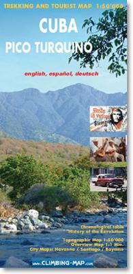
Wandelkaart trekkingmap Cuba - Pico Turquino | Climbing-map

0
Topographic trekking map 1:50'000, city maps of Havanna, Santiago de Cuba and Bayamo, general map 1:1 Mio, trekking route profile, Chronological table, The Cuban Revolution (Map and Text)...

Verkopers met dit product

Verkoper
Bezorging
Prijs
DeZwerver.nl logo
DeZwerver.nl
2,95
20,95

Anderen bekeken ook

Wandelkaart trekkingmap Aconcagua | Climbing-map
Gedetailleerde kaart voor de beklimming van de Aconcagua met op de ene zijde een detailkaart van het hoogste gedeelte met schaal 1:40.000 en op de andere zijde een trekkingmap van de omgeving met de berg in een schaal van 1:100.000. Topographic and thematic climbing map with useful information and illustrations: city map of Mendoza, village map of Puente del Inca, trekking map, description of climbing routes, climatic diagram, vegetation profile, GPS information. Inhalt: Topografische und thematische Bergsteigerkarte 1:40.000 mit diversen Abbildungen und nützlichen Informationen.   Details: Vorderseite: + Topografische Karte Aconcagua im Massstab 1:40.000 + Legende + Panoramabild + Plan Boulderblöcke   Rückseite: + Trekkingkarte 1:100.000  + Streckenprofil von Trekkings und Aufstiegen + Stadtplan Mendoza  + Dorfplan Puente del Inca  + Beschreibung der Aufstiegsrouten in 4 Sprachen  + Routenskizzen von 3 verschiedenen Seiten + Vegetationsstufenprofil  + nützliche allgemeine Information…
21,95
Wandelkaart trekkingmap Elbrus | Climbing-map
Topographic climbing map; village map of Terskol, Cheget and Azau; general map 1:670'000; panorama map; description of climbing routes; route profile; vegetation illustrations, climatic diagram; GPS- information. Sprachen: Englisch, Deutsch, Russisch   Inhalt: Topografische Bergsteigerkarte, Dorfpläne Terskol, Cheget und Azau, Übersichtskarte 1:670'000, Panorama, Routenbeschreibungen, Streckenprofil, Vegetation, Klimadiagramm, GPS-Informationen.   Details: Vorderseite: + Topografische Karte Elbrus im Massstab 1:50.000 + Legende + Panoramabild + GPS Points + Dorfplan Azau   Rückseite: + Übersichtskarte 1:670.000  + Panoramaübersicht  + Elbrus-Chronik  + Streckenprofil  + Dorfplan Terskol  + Dorfplan Cheget  + Beschreibung der Aufstiegsrouten in 3 Sprachen  + Routenskizzen von Süd und Nord  + Flora-Übersicht  + nützliche allgemeine Informationen  + Koordinatensystem: WGS 84 / UTM - Netz      Idee:  Wer als Bergsteiger oder Trekkingtourist weltweit unterwegs ist, stellt bald einmal fest,…
21,95
Wandelkaart trekkingmap Cotopaxi - Ecuador | Climbing-map
Gedetailleerde kaart voor de beklimming van de Cotopaxi  met schaal 1:40.000, op de achterkant een overzichtskaart met schaal 1:250.000. Topographic climbing map with useful information and illustrations: city map of Quito, general map 1:250'000, Avenida de los Volcanes, description of climbing routes, vegetation profile, climatic diagram, GPS- information.. Sprachen: Englisch, Deutsch, Spanisch Inhalt: Topografische Bergsteigerkarte, Stadtplan Quito, Übersichtskarte 1:250'000, Avenida de los Volcanes, Krokis 5 weiterer Vulkane, Routenbeschreibungen, Vegetationsprofil, Klimadiagramm, GPS-Informationen.   + Koordinatensystem: WGS 84 / UTM - Netz    Idee:  Wer als Bergsteiger oder Trekkingtourist weltweit unterwegs ist, stellt bald einmal fest, dass vielerorts kaum brauchbares topografisches Kartenmaterial existiert. Von touristisch bedeutenden Bergen gibt es zwar oftmals haufenweise Bücher und Reiseführer, die Qualität der erhältlichen topografischen Karten lässt aber zu wünschen übrig…
21,95
Wandelkaart 3004 Adventure Map trekkingmap Langtang - Nepal | National Geographic
Each Adventure Map is highly detailed, incredibly durable, waterproof and tear-resistant. Stunning shaded relief brings each map to life, giving you the power to discover, plan and dream. Trail routes, villages, cultivated areas, park boundaries and points of interest make these maps essential gear. Each map includes a beautifully crafted map of the Kingdom of Nepal, inset maps of Kathmandu and Thamel, and a comprehensive index of villages, passages and peaks. Detailed topographic trekking map for Langtang National Park, including coverage for the Shivapuri Watershed, and the Helambu Region. Additional Details: Printed on waterproof, tear-resistant material. Includes detailed place name and locations of useful services. Reverse contains an overview map of the kingdom of Nepal and detailed insets of Kathmandu and Thamel.  
16,50
Wegenkaart - landkaart Cuba | Nelles Verlag
Goede wegenkaart van Cuba. Aan beide kanten bedrukt. Met veel toeristische aanduidingen als nationale parken en culturele bezienswaardigheden. Prima leesbare kaart, nu ook op scheur- en watervast papier Folded road and tourist map of Cuba at 1:775 000 scale. Places of interest, national parks, and beaches are all highlighted and shaded-relief colouring clearly depicts the topography.   The map includes insets showing Varadero at 1:32 000, Camaguey at 1:15 000, Santiago de Cuba at 1:15 000, La Habana (Havana) at 1:15 000, Cienfuegos at 1:23 000 and Trinidad at 1:12 100. The legend is in four languages, including English.   For over 20 years Nelles maps have been renowned throughout the world for their quality, faithfulness to detail and up-to-dateness.    So that streets, ferry links, railway lines, etc are always up to date, Nelles are continuously upgrading their maps - with the help of their international team of correspondents. Roads are provided with an exact kilometerage. Sights …
11,95
Wandelkaart Trekking map Aconcagua | TerraQuest
Gedetailleerde wandelkaart - trekking map van de Aconcagua en omgeving. Handig uitgevoerd: geplastificeerd maar toch makkelijk om te slaan en op te vouwen met de gewenste kant voor. De wandelroutes staan ingetekend, zo ook de berghutten en kampen. Dé kaart om de hoogste berg van Zuid Amerika te beklimmen. Laminated topographic map of Mount Aconcagua (Argentina) published by Terra Quest in 2013. Waterproof and tear-resistant, contoured and GPS compatible map, providing coverage of the Aconcagua Provincial Park with access from the road linking Punta de Vascas, Los Penitentes, Puente del Inca and the Cristo Redentor Tunnel crossing to Chile.   The map divides the area north/south with a good overlap between the sides, extending north to Cerro La Mano on the northern boundary of the park, and south of the road to include Cerro Panitentes. A hiking map characterized by topographic data (contours). An overprint highlights the approach routes to Aconcagua, indicating main trails and difficu…
18,50
Wegenkaart - landkaart Cuba | Freytag & Berndt
Uitstekende kaart van Cuba. Met index, toeristische informatie en afstanden in kilometers.De berijdbare wegen zijn goed weergeven, zowel de hoofdwegen als provinciale en lokale wegen; wegnummers worden vermeld. Afstanden tussen plaatsen zijn in kilometers op de kaart ingetekend. In het kaartbeeld wordt door middel van schaduw het reliëf weergegeven en soms enkele punten in het landschap met de daadwerkelijke hoogte. Provinciegrenzen zijn goed terug te vinden, nationale parken en reservaten ook. Met allerhande symbolen worden toeristische bezienswaardigheden weergegeven als monumenten, historisch belangrijke plekken en uitzichtpunten. In bepaalde plaatsen zijn hotels en campings te vinden, luchthavens, treinverbindingen en havens vindt u er ook op! Overview map with street plans of Havana, Cienfuegos, Camagüey and Santiago de Cuba, plus enlargements of the Playa del Este area east of the capital and the Varadero Peninsula. The main map presents the island’s topography by bold relief sh…
14,95
Pelgrimsroute (kaart) - Wandelkaart Camino Frances, wandelen naar Santiago de Compostela | CNIG - Instituto Geográfico Nacional
Kaarten voor de Camino Frances: Set van 10 topografische kaarten en een overzichtskaart om te wandelen door Noord Spanje naar Santiago de Compostella, op de kaarten  toeristische informatie (zoals overnachten, restaurants, bussen, winkels, etc) met symbolen aangegeven. De kaarten zijn met UTM grid en geschikt voor gebruik met GPS. Op de kaarten zijn ook hoogteprofielen te vinden. De pelgrimsroute is in 38 etappes en loopt vanaf de grens, Pyreneeen naar Santiago.   The whole of Way of St James to Santiago de Compostela in a set of 11 maps: 10 double-sided topographic maps at 1:50,000 plus an overview map of northern Spain, published by the Spanish civilian survey organization. Descriptions in 6 languages; English, French, Spanish, German, Italian & Portuguese   Each 1:50,000 map is double-sided and has four 57 x 35cm panels with full topographic mapping of the area through which the route passes. Contours are at 50m intervals, with additional shading and colouring/graphics to show s…
18,95

Klanten-reviews van Wandelkaart trekkingmap Cuba - Pico Turquino | Climbing-map

Er zijn nog geen beoordelingen voor dit productBen jij de eerste die een review plaatst?

Meer over Wandelkaart trekkingmap Cuba - Pico Turquino | Climbing-map

Productomschrijving

Topographic trekking map 1:50'000, city maps of Havanna, Santiago de Cuba and Bayamo, general map 1:1 Mio, trekking route profile, Chronological table, The Cuban Revolution (Map and Text)

Productinformatie

    Verken gerelateerde categorieën

    Webshop.nl maakt gebruik van cookies. Ga je verder op onze website, ga dan akkoord met het plaatsen van cookies en de verwerking van deze data door ons en vermelde partners.