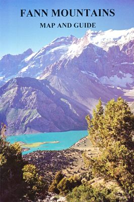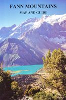
Wandelkaart - Topografische kaart Fann Mountains | EWP

0
Het Fann-gebergte maakt deel uit van het westelijke Pamir-Alay-gebergte in de provincie Sughd in Tadzjikistan, tussen het Zarafshan-gebergte in het noorden en het Gissar-gebergte in het zuiden.    This is one of a series of topographic maps of the mountain ranges of Central Asia.  The map is at a scale of 1:100,000 (1cm = 1km) and contours are sho...

Verkopers met dit product

Webshop
Bezorging
Prijs
DeZwerver.nl logo
DeZwerver.nl
niet bekend
16,95

Anderen bekeken ook

Wandelkaart Tatry Zachodnie | Sygnatura
Goede wandelkaart van het grote westelijke deel van het Tatra gebergte, zowel aan de Poolse als aan de SLowaakse kant. Wandelpaden, campings, hutten, alles staat er op.  Western Tatra Mountains in Poland and Slovakia at 1:25,000 on a contoured and GPS compatible map from CartoMedia highlighting waymarked hiking trails, mountain huts and campsites, places of interest, etc, Coverage extends from Zakopane westwards to Habovka. On the reverse are panels with an overview of the waymarked hiking trails for planning longer routes, a road map showing access to this part of the Tatra Mountains from both sides of the border, a directory of local mountain huts and other useful tourist information, etc.   Maps in the Cartomedia hiking series present topography is by contours at 20m intervals, enhanced by relief shading and, where appropriate, graphic relief for exposed rocky areas. Waymarked hiking trails indicate approximate walking times in both directions and possible danger points. Most title…
9,95
Wandelkaart The Broads | Heron Maps
A full colour map of the Broads suitable for both waterways and leisure users.   This map gives detailed coverage of the Broads with emphasis on the waterways and information useful and relevant to users of the waterways without neglecting other leisure users. The map detail is complimented by information panels and photographs.   Our cruising and tourist map of the Broads is at 1:50000 with detailed town plans at 1:12500 for Wroxham and Hoveton, Stalham, Horning, Potter Heigham, Norwich, Brundall, Beccles, Loddon, Great Yarmouth, Reedham and Oulton Broad.   A double side map with the map on one side and boating and vistor information of the other. The map shows navigation information, visitor moorings, boatyards, boat hire centres, facilities for the boat user and shops. Tourist information includes places of interest, pubs, nature reserves, windmills, churches, long distance paths, public toilets and caravan and camp sites. The reverse side has detailed boating information including…
9,95
Wegenkaart - landkaart Mallorca -Island map and birdwatching guide | Discovery Walking Guides
Kaart van het hele eiland waarop interessante locaties zijn weergegeven voor het observeren van vogels. Als overzichtskaart goed te bruiken, maar de toevoeging van het thema vogels geeft deze kaart net iets extra. Gedrukt op scheur- en watervast papier.  Mallorca Super-Durable Map and Bird Watching Guide combines the latest island map with a full colour Bird Watching Guide. Navigate to your destination then turn over your map to identify the birds you see there.Mallorca Super-Durable Map is a large (125k) scale topographical map of the island detailing all the major, secondary and minor tarmacked roads plus walking trails suitable for bird watching. Printed on a 840mm by 640mm Super-Durable map sheet which folds to a pocketable 220mm by 120mm using a specialist 'concertina map' fold which ensures easy opening, and more importantly easy refolding. Super-Durable Maps come with a 2 year adventurous use wear and tear guarantee, see Discovery Walking Guides website for details. Altitude ba…
15,95
Wandelkaart Tour & Trail Formentera | Discovery Walking Guides
Goede, scheur- en watervaste, wandelkaart van Formentera.   Water-proof, split-proof, tear-proof, adventure-proof. Formentera Tour & Trail Super-Durable Map is simply the toughest, most accurate, easy to read, easy to use map of the island you can buy at any price. David & Ros Brawn surveyed this beautiful island in October 2015 carrying out their 'gps ground survey' pinpointing all the details needed to produce the definitive map of Formentera.   Large, 25k scale, easy to read map sheet includes a wealth of useful details. 20 metre and 100 metre contours combined with altitude shading bring the Formentera landscape to life. All of the legendary Tour & Trail attention to detail is included so that you will find those petrol stations, mirador viewpoints with parking, refreshment stops with parking and accurate road numbering that are so essential when adventuring by hire car; 'watts' new and unique to Formentera we have included the 'Electric hire car' recharging points making sure you…
15,95
Wandelkaart Tour & Trail Malta & Gozo | Discovery Walking Guides
Goede scheur- en watervaste wandelkaart van Malta & Gozo. For the best adventures, use the best map. Water-proof, split-proof, tear-proof, adventure-proof. Malta and Gozo Tour & Trail Super-Durable Map is simply the toughest, most accurate, easy to read, easy to use map of the island you can buy at any price.   Super-Durable Maps come with a 2 year adventurous use `Wear and Tear' guarantee. A large 840mm by 694mm double sided map sheet has Malta at 1:32,000 scale on one side, with Gozo at 1:20,000 scale on the reverse. Our special concertina map fold makes our map easy to use and easy to refold to its 235mm by 120mm pocket size.   Our legendary 'Tour & Trail' level of detail ranges from major roads to secondary roads to minor roads to streets and narrow country roads, plus dirt roads and walking trails. Altitude background colouring is designed to clearly show the altitude range when travelling across the islands by car or on foot. 100 metre and 20 metre contours are clearly shown on …
15,95
Nieuw
Wandelkaart - Topografische kaart 201 Trails Illustrated Yellowstone National Park | National Geographic
Prachtige geplastificeerde kaart van het bekende nationaal park. Met alle recreatieve voorzieningen als campsites, maar ook met topografische details en wandelroutes ed. Door uitgekiend kleurgebruik zeer prettig in gebruik. Scheur en watervast! National Geographic's Trails Illustrated map of Yellowstone National Park is designed to meet the needs of outdoor enthusiasts by combining valuable information with unmatched detail of America's first national park. Expertly researched and created in partnership with local land management agencies, this map features key points of interest including Mammoth Hot Springs, Canyon Village, Yellowstone Lake, Yellowstone Falls, Grant Village, and Old Faithful geyser area.   With over 1,000 miles of mapped trails, the Yellowstone National Park map can guide you off the beaten path and back again. The clearly marked trails include mileages between intersections. Trail summaries provide elevation, duration, and difficulty for a variety of suggested hike…
16,95
Wandelkaart Tour & Trail La Palma | Discovery Walking Guides
Goede, scheur- en watervaste, wandelkaart van La Palma. Water-proof, split-proof, tear-proof, adventure-proof.  La Palma Tour & Trail Super-Durable Map is simply the toughest, most accurate, easy to read, easy to use map of the island you can buy at any price.  Super-Durable Maps now come with a 2 year adventurous use wear and tear guarantee, see Discovery Walking Guides website for details.    7th Edition of our La Palma Tour & Trail Super-Durable Map is a large 1:40,000 scale map, splitting the island into a North (Landscape view) and South (Portrait view) with a generous overlap, produces double sided map of 840mm by 600mm and folds to 235mm by 120mm. Our legendary 'Tour & Trail' level of detail ranges from major roads to secondary roads to minor roads to streets and camino rural narrow country roads, plus dirt roads and walking trails.  Altitude background colouring is designed to clearly show the altitude range when travelling across the island by car or on foot. 100 metre and 50…
15,95
Wandelkaart Tour & Trail Madeira | Discovery Walking Guides
Goed gedetallieerde wandelkaart van Madeira, schaal 1:40.000, scheur en watervast papier. Wandelroutes staan ingetekend. Our large 1:40,000 scale, combined with splitting the island into East and West with a generous overlap, produces double sided map whose total size is 840mm by 600mm and folds to 235mm by 120mm. You get the most detailed map of Madeira that is produced including our 'Tour & Trail' level of detail ranging from major roads to secondary roads to minor roads to streets and camino rural narrow country roads, plus dirt roads and walking trails. Altitude background colouring is designed to clearly show the altitude range when travelling across the island by car or on foot. 100 metre and 50 metre contours are clearly shown on the map along with a large number of individual height points and all of the official 'Trig' points. Tour & Trail attention to detail is legendary as is our useful symbol range including miradors, picnic areas, petrol stations, bar/restaurants and park…
15,95
Wandelkaart Tour & Trail Zakynthos | Discovery Walking Guides
Goede scheur- en watervaste wandelkaart van Zakynthos. For the best adventures, use the best map. Water-proof, split-proof, tear-proof, adventure-proof. Zakynthos (Zante) Tour & Trail Super-Durable Map is simply the toughest, most accurate, easy to read, easy to use map of the island you can buy at any price.   Super-Durable Maps come with a 2 year adventurous use `Wear and Tear' guarantee. A large 840mm by 694mm double sided map sheet has Zakynthos (Zante) at 1:35,000 scale with the North-West of the island on the cover side and the South-East on the reverse. There is a very generous overlap between the two sides so the only time you need to turn the map over is if you are driving from Cape Skinari (NW) to Cape Gerakas (SE) at the opposite end of the island.   Our special concertina map fold makes our map easy to use and easy to refold to its 235mm by 120mm pocket size. You can also download the digital Custom Map edition of our Zakynthos Tour & Trail Map for use with Garmin gps unit…
15,95

Klanten-reviews van Wandelkaart - Topografische kaart Fann Mountains | EWP

Er zijn nog geen beoordelingen voor dit productBen jij de eerste die een review plaatst?

Meer over Wandelkaart - Topografische kaart Fann Mountains | EWP

Productomschrijving

Het Fann-gebergte maakt deel uit van het westelijke Pamir-Alay-gebergte in de provincie Sughd in Tadzjikistan, tussen het Zarafshan-gebergte in het noorden en het Gissar-gebergte in het zuiden.    This is one of a series of topographic maps of the mountain ranges of Central Asia.  The map is at a scale of 1:100,000 (1cm = 1km) and contours are shown at 50m intervals with master contours every 200m.  There are two smaller maps on the reverse, one at 1:100,000 of the ridges, passes, summits and glaciers and one at 1:5,000,000 showing the area covered within the map in it's location within Central Asia.   The reverse of the map is the guide which includes the following:   Location Geology and Relief Climate Glaciation Rivers and lakes Altitude Zoning Mountains and Passes Fauna History Population and language Guides and Donkeys Accommodation and food Conservation and Rubbish/Garbage Countryside and Traditions Useful local works in Russian and Tajik Access, Visas and Permits Useful Contacts.

Verken gerelateerde categorieën

Webshop.nl maakt gebruik van cookies. Ga je verder op onze website, ga dan akkoord met het plaatsen van cookies en de verwerking van deze data door ons en vermelde partners.