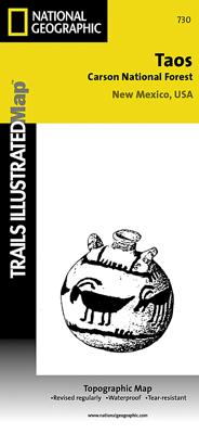
Wandelkaart - Topografische kaart 730 Taos Carson National Forest | National Geographic

0
Prachtige geplastificeerde kaart van het bekende nationaal park. Met alle recreatieve voorzieningen als campsites, maar ook met topografische details en wandelroutes ed. Door uitgekiend kleurgebruik zeer prettig in gebruik. Scheur en watervast! Coverage includes Carson National Forest, Taos, Rancho de Taos, Agua Fria, Black Lake, Valle Escondido, ...

Verkopers met dit product

Verkoper
Bezorging
Prijs
DeZwerver.nl logo
DeZwerver.nl
2,95
17,95

Anderen bekeken ook

Wandelkaart - Topografische kaart 703 Manti La-Sal National Forest | National Geographic
Prachtige geplastificeerde kaart van het bekende nationaal park. Met alle recreatieve voorzieningen als campsites, maar ook met topografische details en wandelroutes ed. Door uitgekiend kleurgebruik zeer prettig in gebruik. Scheur en watervast! Coverage includes Manti-La-Sal National Forest; Dark Canyon Wilderness/Primitive Area; Natural Bridges, New Mexico; Monticello, Blanding, Fry Canyon, Blue Mountains, Woodenshoe and Hammond canyons; Indian Creek and Recapture Lake.
17,95
Wandelkaart - Topografische kaart 810 Shaver Lake - Sierra National Forest | National Geographic
Prachtige geplastificeerde kaart van het bekende nationaal park. Met alle recreatieve voorzieningen als campsites, maar ook met topografische details en wandelroutes ed. Door uitgekiend kleurgebruik zeer prettig in gebruik. Scheur en watervast! Trails Illustrated Shaver Lake / Sierra National Forest is the second of five exciting new maps for the California Sierra Nevadas that will combine to form seamless coverage of the high-use National Forest areas between Sequoia / Kings Canyon National Parks and Lake Tahoe. This region contains some of the most visited backcountry in the United States, popular with hikers, mountain bikers, anglers, hunters, and winter sports enthusiasts.    Like all Trails Illustrated maps, Shaver Lake / Sierra National Forest was developed in collaboration with local agencies and experts, in this case the Three Forests Interpretive Association which supports Sierra, Stanislaus, and Sequoia National Forests.   Shaver Lake contains coverage for Sierra National Fo…
17,95
Wandelkaart - Topografische kaart 206 Yosemite National Park | National Geographic
Prachtige geplastificeerde kaart van het bekende nationaal park. Met alle recreatieve voorzieningen als campsites, maar ook met topografische details en wandelroutes ed. Door uitgekiend kleurgebruik zeer prettig in gebruik. Scheur en watervast! Coverage includes Stanislaus National Forest, Emigrant Wilderness, Carson Iceberg Wilderness, Toiyabe National Forest, Hoover Wilderness, Inyo National Forst, Yosemite Wilderness, Sierra National Forest, Ansel Adams Wilderness. Detail on Yosemite Valley and Tuolumne Meadows. Includes UTM grids for use with your GPS unit. Coverage includes Stanislaus National Forest, Emigrant Wilderness, Carson Iceberg Wilderness, Toiyabe National Forest, Hoover Wilderness, Inyo National Forst, Yosemite Wilderness, Sierra National Forest, Ansel Adams Wilderness. Detail on Yosemite Valley and Tuolumne Meadows
16,95
Wandelkaart - Topografische kaart 702 Cedar Mountain - Pine Valley Mountain - Dixie National Forest | National Geographic
Prachtige geplastificeerde kaart van het bekende nationaal park. Met alle recreatieve voorzieningen als campsites, maar ook met topografische details en wandelroutes ed. Door uitgekiend kleurgebruik zeer prettig in gebruik. Scheur en watervast! Coverage includes Dixie National Forest, Ashdown Gorge Wilderness, Cedar Breaks National Monument, Brian Head, Navajo Lake, Haycock Mountain, Panguitch Lake, Long Valley Junction and Duck Creek. Includes UTM grids for use with your GPS unit.
17,95
Wandelkaart - Topografische kaart 779 Linville Gorge - Mount Mitchell - Pisgah National Forest | National Geographic
Prachtige geplastificeerde kaart van het bekende nationaal park. Met alle recreatieve voorzieningen als campsites, maar ook met topografische details en wandelroutes ed. Door uitgekiend kleurgebruik zeer prettig in gebruik. Scheur en watervast! Coverage includes Pisgah National Forest, Grandfather Ranger District (complete) and Appalachian Ranger District. Towns: Black Mountain, Marion, Morganton, Linville, Burnsville. Wilderness areas: Linville Gorge. Scenic drives: Blue Ridge Parkway. Other highlights: Mount Mitchell State Park, Grandfther Mountain Biosphere Reserve, Wilson Creek Wild and Scenic River, Brown Mountain OHV Area, South Toe River, Mountains-to-Sea Trail, and Lake James State Park. Includes UTM grids for use with your GPS unit and a trail mileage matrix.
17,95
Wandelkaart - Topografische kaart 303 Mammoth Hot Springs Yellowstone National Park | National Geographic
Prachtige geplastificeerde kaart van het nationaal park. Met alle recreatieve voorzieningen als campsites, maar ook met topografische details en wandelroutes ed. Door uitgekiend kleurgebruik zeer prettig in gebruik. Scheur en watervast! Coverage of the Old Faithful area of Yellowstone National Park includes Heart Lake BMA, Pitchstone Plateau, Bechler Ranger Station, South Entrance, Teton Wilderness, John D. Rockefeller Jr Memorial Parkway, Jedediah Smith Wilderness, Winegar Hole Wilderness, Bechler Canyon, Cascade Corner, Firehole BMA, Shoshone Lake, Western half of Yellowstone Lake. Includes UTM grids for use with your GPS unit.
14,95
Wandelkaart - Topografische kaart 248 Katmai National Park & Preserve | National Geographic
Prachtige geplastificeerde kaart van het nationaal park. Met alle recreatieve voorzieningen als campsites, maar ook met topografische details en wandelroutes ed. Door uitgekiend kleurgebruik zeer prettig in gebruik. Scheur en watervast! This two-sided map includes Katmai National Park and Wilderness in its entirety, Becharof National Wildlife Refuge, Becharof Wilderness Area, Alaska Peninsula National Wildlife Refuge, Alagnak Wild River Katmai National Preserve, McNeil River State Game Refuge, McNeil River State Game Sanctuary, Iliamna Lake, Kukaklek Lake, Naknek Lake, Kvichak Bay, Becharof LAke, Upper Ugashik Lake, Puale Bay, Katmai Bay, and the Shelikof Strait. Also included are Mt Katmai, Trident Bolcano, Novatupta, Mt. Mageik, Mt. Martin, Three Forks Overlook, and Brooks Camp. The map features Wilderness Safety tips, land use regulations, and information on how best to react to bear encounters. Beautiful cartography shows the mountains, rivers, marsh areas, and natural features of…
16,95
Wandelkaart - Topografische kaart 210 Canyonlands National Park | National Geographic
Prachtige geplastificeerde kaart van het nationaal park. Met alle recreatieve voorzieningen als campsites, maar ook met topografische details en wandelroutes ed. Door uitgekiend kleurgebruik zeer prettig in gebruik. Scheur en watervast! Trails Illustrated maps are the most trusted and popular recreation maps available. Continually setting the standard for accuracy, each map is crafted in conjunction with local land managers, and undergoes rigorous review and enhancement before being printed on waterproof, tear-resistant material. Each Trails Illustrated map contains detailed topographic information, clearly marked and named trails, recreational points of interest, and navigational aids. National Park series maps contain useful details for planning your visit. State series titles cover popular recreation areas, ideal for done-in-a-day activities. Included on the map are Canyonlands National Park, the Island in the Sky district, the Needles district, and the Maze district. The map also …
16,95
Wandelkaart - Topografische kaart 302 Old Faithful, Yellowstone National Park SW | National Geographic
Prachtige geplastificeerde kaart van het bekende nationaal park. Met alle recreatieve voorzieningen als campsites, maar ook met topografische details en wandelroutes ed. Door uitgekiend kleurgebruik zeer prettig in gebruik. Scheur en watervast!   Beautiful waterproof and tear-resistant topographical hiking map of a well-loved National Park, with campsites and walking routes clearly marked. Coverage of the Old Faithful area of Yellowstone National Park includes Heart Lake BMA, Pitchstone Plateau, Bechler Ranger Station, South Entrance, Teton Wilderness, John D. Rockefeller Jr Memorial Parkway, Jedediah Smith Wilderness, Winegar Hole Wilderness, Bechler Canyon, Cascade Corner, Firehole BMA, Shoshone Lake, Western half of Yellowstone Lake. Includes UTM grids for use with your GPS unit.
14,95

Klanten-reviews van Wandelkaart - Topografische kaart 730 Taos Carson National Forest | National Geographic

Er zijn nog geen beoordelingen voor dit productBen jij de eerste die een review plaatst?

Meer over Wandelkaart - Topografische kaart 730 Taos Carson National Forest | National Geographic

Productomschrijving

Prachtige geplastificeerde kaart van het bekende nationaal park. Met alle recreatieve voorzieningen als campsites, maar ook met topografische details en wandelroutes ed. Door uitgekiend kleurgebruik zeer prettig in gebruik. Scheur en watervast!

Coverage includes Carson National Forest, Taos, Rancho de Taos, Agua Fria, Black Lake, Valle Escondido, Penasco, Chacon, and Northern Pecos Wilderness.

Productinformatie

    Verken gerelateerde categorieën

    Webshop.nl maakt gebruik van cookies. Ga je verder op onze website, ga dan akkoord met het plaatsen van cookies en de verwerking van deze data door ons en vermelde partners.