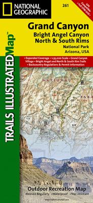
Wandelkaart - Topografische kaart 261 Grand Canyon | National Geographic

0
Prachtige geplastificeerde kaart van het bekende nationaal park. Met alle recreatieve voorzieningen als campsites, maar ook met topografische details en wandelroutes ed. Door uitgekiend kleurgebruik zeer prettig in gebruik. Scheur en watervast!   Explore the uniquely inspiring and wondrous landscape of the Grand Canyon with National Geographic's T...

Verkopers met dit product

Webshop
Bezorging
Prijs
DeZwerver.nl logo
DeZwerver.nl
2,95
16,95

Anderen bekeken ook

Nieuw
Wandelkaart - Topografische kaart 201 Trails Illustrated Yellowstone National Park | National Geographic
Prachtige geplastificeerde kaart van het bekende nationaal park. Met alle recreatieve voorzieningen als campsites, maar ook met topografische details en wandelroutes ed. Door uitgekiend kleurgebruik zeer prettig in gebruik. Scheur en watervast! National Geographic's Trails Illustrated map of Yellowstone National Park is designed to meet the needs of outdoor enthusiasts by combining valuable information with unmatched detail of America's first national park. Expertly researched and created in partnership with local land management agencies, this map features key points of interest including Mammoth Hot Springs, Canyon Village, Yellowstone Lake, Yellowstone Falls, Grant Village, and Old Faithful geyser area.   With over 1,000 miles of mapped trails, the Yellowstone National Park map can guide you off the beaten path and back again. The clearly marked trails include mileages between intersections. Trail summaries provide elevation, duration, and difficulty for a variety of suggested hike…
16,95
Nieuw
Wandelkaart - Topografische kaart 146 Uncompahgre Plateau South | National Geographic
Prachtige geplastificeerde kaart van het bekende nationaal park. Met alle recreatieve voorzieningen als campsites, maar ook met topografische details en wandelroutes ed. Door uitgekiend kleurgebruik zeer prettig in gebruik. Scheur en watervast!   National Geographic's Trails Illustrated map of Uncompahgre Plateau South is a two-sided, waterproof map designed to meet the needs of outdoor enthusiasts with unmatched durability and detail. This map was created in conjunction with local land management agencies and is loaded with valuable recreation information.   The front side of the map details the southeastern portion of the Plateau and Uncompahgre National Forest, as well as Ridgway State Park. On the reverse side of the map, the southwestern portion of Uncompahgre National Forest, including the Naturita Division, is featured as well as the Tabeguache Area, Roubideau Special Management Area, Unaweep/Tabeguache Scenic and Historic Byway, and Dry Creek Basin and Dan Noble State Wildl…
17,95
Nieuw
Wandelkaart 01 Jasper National Park & Maligne Lake | Gem Trek Maps
Scheur- en Watervast papier Gem Trek’s JASPER AND MALIGNE LAKE MAP map is designed for outdoor enthusiasts looking to explore the section of Jasper National Park near the town and out to Maligne Lake. Whether you are touring along the roads or heading into the backcountry, you’ll find the waterproof and tear-resistant Jasper & Maligne Lake Map to be an invaluable tool.   This map features detailed cartography, accurate hiking trails with distances, and details such as campgrounds, equestrian routes, picnic areas, and fire lookouts. On the back of the map are trail descriptions and photos of 18 recommended day hikes, four overnight or multi-day trips, and six classic mountain bike rides. Each of these described trails is referenced and colour-coded to the map on the front. Also on the back is contact information for Jasper National Park, as well for as the three backcountry lodges located in the Tonquin Valley and on the Skyline Trail.   Jasper & Maligne Lake Map Coverage The Jas…
16,95
Reisgids - Wandelgids Grand Canyon National Park | Lonely Planet
Uitstekende gids over dit specifieke park met alle dingen die je er kunt doen. Veel praktische adressen en kaartjes, goede beschrijvingen etc. Lonely Planet's Grand Canyon National Parks is your passport to the most relevant, up-to-date advice on what to see and skip. Hike the Hermit trail, swim in Oak Creek, and ride the Colorado river; all with your trusted travel companion. Get to the heart of Grand Canyon National Parks and begin your journey now!   Inside the Lonely Planet's Grand Canyon National Parks Travel Guide:   User-friendly highlights and itineraries help you tailor your trip to your personal needs and interests   Insider tips to save time and money and get around like a local, avoiding crowds and trouble spots   Essential info at your fingertips - hours of operation, phone numbers, websites, transit tips, prices, emergency information, park seasonality, hiking trail junctions, viewpoints, landscapes, elevations, distances, difficulty levels, and durations   F…
23,95
Nieuw
Wandelkaart - Topografische kaart 746 Adirondack Park - Saranac - Paul Smiths | National Geographic
Prachtige geplastificeerde kaart van het bekende nationaal park. Met alle recreatieve voorzieningen als campsites, maar ook met topografische details en wandelroutes ed. Door uitgekiend kleurgebruik zeer prettig in gebruik. Scheur en watervast!   National Geographic's Trails Illustrated map of Adirondack Park Saranac/Paul Smiths is a two-sided, waterproof, topographic trail map designed to meet the needs of outdoor enthusiasts with unmatched durability and detail. This map was created in cooperation with the Adirondack Mountain Club and is loaded with valuable recreation information, from the marsh to the forest, alongside lakes and through historic neighborhoods. Trails and major roads are clearly distinguished, along with canoe access and ski areas. Campgrounds, lookout towers, rock climbing, and fishing easements are labeled and easy to find and boundaries for park lands, wilderness, primitive, forest, and protected areas are clearly marked. Discover the Adirondack's wild, rugged a…
17,95
Reisgids Best of Grand Canyon | Moon Travel Guides
Whether you're stopping for a day hike or spending a long weekend under the stars, escape to the great outdoors with Moon Best of Grand Canyon. Inside you'll find: Easy itineraries for one to three days in Grand Canyon National Park, from a morning bike ride along the South Rim, to a day hike in the inner canyon, to a full weekend exploring the park The top hikes in Grand Canyon: Whether you're looking to stretch your legs for a couple hours or challenge yourself to an epic trek, you'll find trailheads, detailed trail descriptions, individual maps, mileage, and elevation gains Can't-miss experiences: Make it the perfect getaway for you with the best views, scenic drives, picnic spots, and more. Trek into Havasu Canyon to see stunning waterfalls or drive to viewpoints along Hermit Road. Go on a rafting adventure on the Colorado River and spot wildlife like elk and bighorn sheep Stunning full-color photos and maps throughout, plus a full-color foldout map Essential planning tips…
19,95
Reisgids Grand Canyon | Moon Travel Guides
Experience the serene vistas and unforgettable thrills of this stunning national treasure with Moon Grand Canyon. Inside you'll find: Flexible Itineraries: Adventure-packed ideas for anything from a week-long trip to a single day in the park Strategic Advice: Find tips for outdoor adventurers, families, history buffs, and more, with options for different levels of accessibility and tips on minimizing your environmental impact The Best Hikes in and Around the Grand Canyon: Detailed descriptions, individual trail maps, mileage and elevation gains, and backpacking options Get Outside: Go backcountry camping in the inner canyon or rafting down the Colorado River. Head to the Havasupai reservation's Havasu Canyon for a waterfall-filled hike, or ride horseback through the South Rim. Mountain bike along the Rainbow Rim or stroll along a 70-foot skywalk stretching into the canyon Experience Native American Culture: Advice on respectfully visiting reservations, supporting local business…
19,95
Reisgids - Wandelgids Grand Canyon National Park | Destination Press
Discover the best of Grand Canyon National Park in this award-winning, full-color travel guidebook. From hiking to biking to river rafting, Grand Canyon National Park is filled with adventures. But without careful planning, a trip there can be overwhelming.   Grand Canyon: The Complete Guide helps you make the most of your time in the park. Whatever your interests-hiking the Bright Angel Trail, riding mules to Phantom Ranch, watching sunset from Hopi Point, relaxing at a historic lodge-this gorgeous travel guidebook puts the best of Grand Canyon at your fingertips. Beautiful color photos showcase the park's best viewpoints and destinations.   Fascinating chapters on Geology, History and Wildlife reveal the story behind the scenery. Detailed maps make travel planning easy. From Havasu Canyon's stunning waterfalls to incredible day hikes on the North and South Rims, Grand Canyon: The Complete Guide is the only guidebook you'll need.   Filled with tips to save you time and money! Winner:…
24,95
Nieuw
Wandelkaart - Topografische kaart 316 Cades Cove - Elkmont - Great Smoky Mountains National Park | National Geographic
Prachtige geplastificeerde kaart van het bekende nationaal park. Met alle recreatieve voorzieningen als campsites, maar ook met topografische details en wandelroutes ed. Door uitgekiend kleurgebruik zeer prettig in gebruik. Scheur en watervast!   This title provides an increased scale of one of the most visited National Parks in the US, and one of our more popular map titles. This increased scale will provide greater detail to the backcountry users and Appalachian Trail through-hikers.   Great Smoky Mountains National Park is a hiker's paradise with over 800 miles of maintained trails ranging from short legstretchers to strenuous treks that may require backcountry camping. But hiking is not the only reason for visiting the Smokies. Car camping, fishing, picnicking, wildlife viewing and auto touring are popular activities.   Coverage Highlights Areas and places featured in this map series (TI316 and TI317) include: • Appalachian Trail • Benton Mackaye Trail • Mountains-to-Sea Trail • B…
14,95
Wandelkaart - Topografische kaart OL03 OS Explorer Map Meon Valley - Portsmouth, Gosport & Fareham | Ordnance Survey
Met zijn 4cm voor 1 km (2 ½ cm voor 1 mijl) schaal, is de OS Outdoor Leisure kaartenserie de ideale en meest gedetailleerde kaartenreeks voor mensen die graag outdoor-activiteiten zoals fietsen, wandelen, paardrijden, klimmen en watersporten. Deze kaart is nog gedetailleerder dan de 'gewone' Landranger maps. Voor- en achterzijde bedrukt! Zeker op de moors en andere natuurgebieden van onschatbare waarden met echt alle aspecten van het landschap op de kaart ingetekend. Zeer goede detailkaart met topografische ondergrond. Hierop zijn toeristische symbolen van bezienswaardigheden ingetekend, daarnaast staan bijvoorbeeld campings en jeugdherbergen vermeld en - voor wandelaars het belangrijkst - alle right of way paden en Lange afstands Wandelpaden zijn er op te vinden. De ideale kaart voor het wandelen in Engeland, Wales of Schotland. With a wealth of naval history behind it Portsmouth lies at the southern edge of this map that stretches north taking in Fareham, Waterlooville, Droxford and…
19,50

Klanten-reviews van Wandelkaart - Topografische kaart 261 Grand Canyon | National Geographic

Er zijn nog geen beoordelingen voor dit productBen jij de eerste die een review plaatst?

Meer over Wandelkaart - Topografische kaart 261 Grand Canyon | National Geographic

Productomschrijving

Prachtige geplastificeerde kaart van het bekende nationaal park. Met alle recreatieve voorzieningen als campsites, maar ook met topografische details en wandelroutes ed. Door uitgekiend kleurgebruik zeer prettig in gebruik. Scheur en watervast!
 

Explore the uniquely inspiring and wondrous landscape of the Grand Canyon with National Geographic's Trails Illustrated map of Grand Canyon National Park, North and South Rims. Expertly researched and created in partnership with local land management agencies, this map is designed to meet the needs of outdoor enthusiasts with unmatched detail of the heart of the park. Key areas of interest featured on this map include Colorado River miles 60-98, North and South Rim visitor centers, Grand Canyon Village, Tusayan, Bright Angel Trail (plus elevation profile), West Rim Trail, Kaibab Trail, Arizona Trail, and more.   With miles of mapped trails in some of the most breathtaking scenery in the entire country, the Grand Canyon North and South Rims map can guide you off the beaten path and back again. Designed with a wide range of visitors in mind, this map features detailed and easy to read trails, accurate road network, campgrounds, scenic overlooks and points of interests, visitor centers and facilities, color coded bus stops with routes, plus park regulations, backcountry use areas, and contact information for local agencies. The map base includes contour lines and elevations for summits, passes and major lakes.   Every Trails Illustrated map is printed on "Backcountry Tough" waterproof, tear-resistant paper. A full UTM grid is printed on the map to aid with GPS navigation.   Other features found on this map include: Grand Canyon National Park, Kaibab National Forest, Little Colorado River, Marble Canyon.

Verken gerelateerde categorieën

Webshop.nl maakt gebruik van cookies. Ga je verder op onze website, ga dan akkoord met het plaatsen van cookies en de verwerking van deze data door ons en vermelde partners.