webshop.nl
Categorieën
  Sluiten

Meer National Geographic
Meer National Geographic in Literatuur boeken

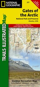
Wandelkaart - Topografische kaart 257 Trails Illustrated Gates of the

0
Prachtige geplastificeerde kaart van het nationaal park. Met alle recreatieve voorzieningen als campsites, maar ook met topografische details en wandelroutes ed. Door uitgekiend kleurgebruik zeer prettig in gebruik. Scheur en watervast! Let National Geographic's Trails Illustrated map for Gates of the Arctic National Park and Preserve guide you on...

Webshops met dit product

Webshop
Bezorging
Prijs

Anderen bekeken ook

Alighieri The Teardrop of the Night onyx ring - Or
gold plated onyx stone textured finish slip-on style We've partnered with Good On You — an independent agency that rates how brands perform in relation to their impact on the planet, people and animals, with a multi-criteria rating simplified to a five points scale. In order to be awarded our conscious label, larger brands need to score a minimum of four out of five ('Good'), while smaller brands must score at least three out of five ('It's a start'). This item comes from a brand rated four out of five ('Good') by Good on You at the time it was added on FARFETCH. Please note, this is a brand-level rating and does not guarantee that this product is made with conscious materials. Learn more about what makes a product Conscious on our Conscious Criteria page
304,-
Alighieri The Garnet of Desire bracelet - Or
24kt gold plated bronze gold vermeil garnet curb chain lobster claw fastening We've partnered with Good On You - an independent agency that rates how brands perform in relation to their impact on the planet, people and animals, with a multi-criteria rating simplified to a five points scale. In order to be awarded our conscious label, larger brands need to score a minimum of four out of five ('Good'), while smaller brands must score at least three out of five ('It's a start'). This item comes from a brand rated four out of five ('Good') by Good on You at the time it was added on FARFETCH. Please note, this is a brand-level rating and does not guarantee that this product is made with conscious materials. Learn more about what makes a product Conscious on our Conscious Criteria page
324,-

Klanten-reviews van Wandelkaart - Topografische kaart 257 Trails Illustrated Gates of the

Er zijn nog geen beoordelingen voor dit productBen jij de eerste die een review plaatst?

Meer over Wandelkaart - Topografische kaart 257 Trails Illustrated Gates of the

Productomschrijving

Prachtige geplastificeerde kaart van het nationaal park. Met alle recreatieve voorzieningen als campsites, maar ook met topografische details en wandelroutes ed. Door uitgekiend kleurgebruik zeer prettig in gebruik. Scheur en watervast! Let National Geographic's Trails Illustrated map for Gates of the Arctic National Park and Preserve guide you on your adventure in this remote wilderness of northern Alaska. With neither roads or trails within the park, the map's contour lines, elevations, labeled peaks and summits, water features will be essential in your navigation of the area. Coverage includes many land and water points of interest within the park, as well as in neighboring areas, including the Brooks Range; Noatak, Alatna, John, Tinayguk and Koyukuk Wild and Scenic Rivers; Schwatka and Endicott Mountains; Yukon Flats and Kanuti National Wildlife Refuge Area; Noatak National Preserve; Walker Lake; Anaktuvuk Pass; and the Continental Divide. Also pinpointed are the area's bush airstrips; Marion Creek and Galbraith Lake campgrounds; the communities of Wiseman, Coldfoot, Evansville and Bettles; and a nearly 200 mile stretch of the Dalton Highway with its roadside facilities.   The reverse side of the map features a spectacular map of Alaska, mapped with all of her national parks and preserves, along with background information about each one. Detailed information about Gates of the Arctic National Park and Preserve is provided, as are trip planning tips, backcountry activities and safety tips, minimum impact guidelines and essential contact information. This expertly researched map was created in cooperation with the National Park Service, Bureau of Land Management and others.   Every Trails Illustrated map is printed on "Backcountry Tough" waterproof, tear-resistant paper. A full UTM grid is printed on the map to aid with GPS navigation.   Other features found on this map include: Alatna River, Brooks Range, Chandler Lake, Cockedhat Mountain, Easter Creek, Endicott Mountains, Fish Creek, Gates of the Arctic National Park, Gates of the Arctic National Preserve, Iniakuk Lake, Jim River, John River, Lake Selby, Mauneluk River, Middle Fork Koyukuk River, Mount Igikpak, Nigu River, Noatak National Preserve, North Fork Koyukuk River, Norutak Lake, Nutuvukti Lake, Reed River, Schwatka Mountains, South Fork Koyukuk River, Walker Lake.

Productspecificaties

Artikelnummer(s)
Brand
National Geographic

Verken gerelateerde categorieën

Webshop.nl maakt gebruik van cookies. Ga je verder op onze website, ga dan akkoord met het plaatsen van cookies en de verwerking van deze data door ons en vermelde partners.