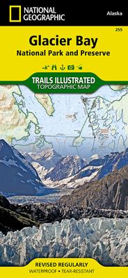
Wandelkaart - Topografische kaart 255 Glacier Bay National Park & Preserve | National Geographic

0
Prachtige geplastificeerde kaart van het nationaal park. Met alle recreatieve voorzieningen als campsites, maar ook met topografische details en wandelroutes ed. Door uitgekiend kleurgebruik zeer prettig in gebruik. Scheur en watervast! This Trails Illustrated map for Glacier Bay National Park, Glacier Bay National Preserve, and surrounding area a...

Verkopers met dit product

Verkoper
Bezorging
Prijs
DeZwerver.nl logo
DeZwerver.nl
2,95
16,95

Anderen bekeken ook

Wandelkaart - Topografische kaart 248 Katmai National Park & Preserve | National Geographic
Prachtige geplastificeerde kaart van het nationaal park. Met alle recreatieve voorzieningen als campsites, maar ook met topografische details en wandelroutes ed. Door uitgekiend kleurgebruik zeer prettig in gebruik. Scheur en watervast! This two-sided map includes Katmai National Park and Wilderness in its entirety, Becharof National Wildlife Refuge, Becharof Wilderness Area, Alaska Peninsula National Wildlife Refuge, Alagnak Wild River Katmai National Preserve, McNeil River State Game Refuge, McNeil River State Game Sanctuary, Iliamna Lake, Kukaklek Lake, Naknek Lake, Kvichak Bay, Becharof LAke, Upper Ugashik Lake, Puale Bay, Katmai Bay, and the Shelikof Strait. Also included are Mt Katmai, Trident Bolcano, Novatupta, Mt. Mageik, Mt. Martin, Three Forks Overlook, and Brooks Camp. The map features Wilderness Safety tips, land use regulations, and information on how best to react to bear encounters. Beautiful cartography shows the mountains, rivers, marsh areas, and natural features of…
16,95
Wandelkaart - Topografische kaart 243 Everglades National Park | National Geographic
Prachtige geplastificeerde kaart van het nationaal park. Met alle recreatieve voorzieningen als campsites, maar ook met topografische details en wandelroutes ed. Door uitgekiend kleurgebruik zeer prettig in gebruik. Scheur en watervast! This Trails Illustrated topographic map for Everglades National Park and surrounding area is the perfect map for hiking, boating, paddling, biking, fishing, exploring, camping, and sightseeing in this unique national treasure.   This two-sided map includes the Key Largo, Everglades City, Chokoloskee, Everglades National Park, portions of Big Cypress National Preserve, Fakahatchee Strand State Preserve, Cape Romano Ten Thousand Islands Aquatic Preserve, Shark Valley Tram Road, Old Ingraham highway and campsite, North Nest Key, West Lake Canoe Trail, Snake Bight Trail, backcountry campsites, beach sites, ground sites, and chickees, and detailed insets of Flamingo, Whitewater Bay, Pineland Trails of the Long Pine Key area, and Nine Mile Pond. The map also…
16,95
Wandelkaart - Topografische kaart 772 Delmarva Peninsula | National Geographic
Prachtige geplastificeerde kaart van het bekende nationaal park. Met alle recreatieve voorzieningen als campsites, maar ook met topografische details en wandelroutes ed. Door uitgekiend kleurgebruik zeer prettig in gebruik. Scheur en watervast! The new Delmarva Trails Illustrated regional topographic recreation map covers all major recreation areas for the Peninsula and Chesapeake Bay region. This beautifully designed map includes all state parks, state wildlife areas, national wildlife areas and key recreation access points. Locations for camping, boating, canoeing/kayaking, hunting, biking/greenways, and fishing are displayed. Highlights include Blackwater and Chincoteague National Wildlife Refuges, Assateague Island National Seashore, Cape Henlopen State Park, and Maryland's Eastern Shore. This map will be an essential trip planning tool, road map, and on-the-ground guide for accessing Delmarva Peninsula's public lands. Includes UTM grids for use with your GPS unit.
17,95
Wandelkaart - Topografische kaart 212 Acadia National Park | National Geographic
Prachtige geplastificeerde kaart van het nationaal park. Met alle recreatieve voorzieningen als campsites, maar ook met topografische details en wandelroutes ed. Door uitgekiend kleurgebruik zeer prettig in gebruik. Scheur en watervast! Trails Illustrated maps are the most trusted and popular recreation maps available. Continually setting the standard for accuracy, each map is crafted in conjunction with local land managers, and undergoes rigorous review and enhancement before being printed on waterproof, tear-resistant material. Each Trails Illustrated map contains detailed topographic information, clearly marked and named trails, recreational points of interest, and navigational aids. National Park series maps contain useful details for planning your visit. State series titles cover popular recreation areas, ideal for done-in-a-day activities. Features Mount Desert Island, Sestern Mountain, Norwood Ridge, Freeman Ridge, Isle au Haut, Marshall Island, Swans Island, Western Bay, Mount…
16,95
Wandelkaart 249 Wrangell and St.Elias National Park | National Geographic
Prachtige geplastificeerde kaart van het bekende nationaal park. Met alle recreatieve voorzieningen als campsites, maar ook met topografische details en wandelroutes ed. Door uitgekiend kleurgebruik zeer prettig in gebruik. Scheur en watervast! This two-sided map (325.000) covers Wrangell - St. Elias National Park in its entirety, along with Tetlin National Wildlife Refuge, portions of Chugach National Forest, the Bering Glacier, Robinson Mountains, Chugach Mountains, Wrangell Mountains, and Kayak Island State Marine Park. Towns include Katalla, Mt. Hazelet, Cape Yakataga, Kennicott, McCarthy, Slana, and Glennallen. The map features two detailed insets (85.000). The first includes Yakutat Bay, Disenchantment Bay, Russel Fjord, Nunatak Fjord, the Malaspina Glacier. The second detailed inset shows the Kennicott and McCarthy areas, along with the Bonanza Ridge, Fireweed Mountain, and the Nizina River.
17,95
Wandelkaart - Topografische kaart 211 Arches National Park | National Geographic
Prachtige geplastificeerde kaart van het nationaal park. Met alle recreatieve voorzieningen als campsites, maar ook met topografische details en wandelroutes ed. Door uitgekiend kleurgebruik zeer prettig in gebruik. Scheur en watervast! Trails Illustrated maps are the most trusted and popular recreation maps available. Continually setting the standard for accuracy, each map is crafted in conjunction with local land managers, and undergoes rigorous review and enhancement before being printed on waterproof, tear-resistant material. Each Trails Illustrated map contains detailed topographic information, clearly marked and named trails, recreational points of interest, and navigational aids. National Park series maps contain useful details for planning your visit. State series titles cover popular recreation areas, ideal for done-in-a-day activities. Included on the map are Arches National Park, The Highlands, Little Valley, Devils Garden, Lost Spring Canyon Wilderness area, Negro Bill Wil…
16,95
Wandelkaart - Topografische kaart 210 Canyonlands National Park | National Geographic
Prachtige geplastificeerde kaart van het nationaal park. Met alle recreatieve voorzieningen als campsites, maar ook met topografische details en wandelroutes ed. Door uitgekiend kleurgebruik zeer prettig in gebruik. Scheur en watervast! Trails Illustrated maps are the most trusted and popular recreation maps available. Continually setting the standard for accuracy, each map is crafted in conjunction with local land managers, and undergoes rigorous review and enhancement before being printed on waterproof, tear-resistant material. Each Trails Illustrated map contains detailed topographic information, clearly marked and named trails, recreational points of interest, and navigational aids. National Park series maps contain useful details for planning your visit. State series titles cover popular recreation areas, ideal for done-in-a-day activities. Included on the map are Canyonlands National Park, the Island in the Sky district, the Needles district, and the Maze district. The map also …
16,95
Wandelkaart - Topografische kaart 257 Trails Illustrated Gates of the Arctic National Park & Preserve | National Geographic
Prachtige geplastificeerde kaart van het nationaal park. Met alle recreatieve voorzieningen als campsites, maar ook met topografische details en wandelroutes ed. Door uitgekiend kleurgebruik zeer prettig in gebruik. Scheur en watervast! Let National Geographic's Trails Illustrated map for Gates of the Arctic National Park and Preserve guide you on your adventure in this remote wilderness of northern Alaska. With neither roads or trails within the park, the map's contour lines, elevations, labeled peaks and summits, water features will be essential in your navigation of the area. Coverage includes many land and water points of interest within the park, as well as in neighboring areas, including the Brooks Range; Noatak, Alatna, John, Tinayguk and Koyukuk Wild and Scenic Rivers; Schwatka and Endicott Mountains; Yukon Flats and Kanuti National Wildlife Refuge Area; Noatak National Preserve; Walker Lake; Anaktuvuk Pass; and the Continental Divide. Also pinpointed are the area's bush airs…
16,95
Wandelkaart - Topografische kaart 254 Chilkoot Trail | National Geographic
Prachtige geplastificeerde kaart van het nationaal park. Met alle recreatieve voorzieningen als campsites, maar ook met topografische details en wandelroutes ed. Door uitgekiend kleurgebruik zeer prettig in gebruik. Scheur en watervast!   National Geographic's Trails Illustrated map for Chilkoot Trail in Klondike Gold Rush National Historic Park in the Alaskan panhandle is perfect for hiking, camping, and wildlife viewing in this scenic, rugged frontier. Created in partnership with local land management agencies, this expertly researched map features key areas of interest including Chilkoot Trail National Historic Site; portions of the Klondike Highway; Happy Camp; Taiya Inlet; the town of Skagway; Klondike Gold Rush National Historical Park; Skagway River; Dyea; and Deep, Bennett, Crater, Long, and Lindeman lakes.   The print map includes insets of historic routes to the Klondike gold fields, Historic Dyea, and Skagway Historic District with some of the prominent gold rush-era bui…
16,95
Wandelkaart - Topografische kaart 820 Mount Hood and Willamette National Forests | National Geographic
Prachtige geplastificeerde kaart van het bekende nationaal park. Met alle recreatieve voorzieningen als campsites, maar ook met topografische details en wandelroutes ed. Door uitgekiend kleurgebruik zeer prettig in gebruik. Scheur en watervast! Located just outside of Portland, Mt. Hood is the tallest peak in Oregon, the fourth highest in the Cascade Range, and a premier destination for outdoor enthusiasts. The mountain has six ski areas, the renowned Timberline Lodge located on the southern flank beside the Palmer Glacier, and is part of the 1.0M acre Mt. Hood National Forest.   Our detailed Trails Illustrated recreation map of Mt. Hood contains carefully researched trails, campsites, forest service roads, and points-of-interests.   Backcountry users will find the UTM and Latitude/Longitude grids as well as other accurate navigation features perfect for exploring the region confidently and safely.   Areas included on the map: - Badger Creek, Bull of the Woods, Mount Hood, and Salmon …
17,95

Klanten-reviews van Wandelkaart - Topografische kaart 255 Glacier Bay National Park & Preserve | National Geographic

Er zijn nog geen beoordelingen voor dit productBen jij de eerste die een review plaatst?

Meer over Wandelkaart - Topografische kaart 255 Glacier Bay National Park & Preserve | National Geographic

Productomschrijving

Prachtige geplastificeerde kaart van het nationaal park. Met alle recreatieve voorzieningen als campsites, maar ook met topografische details en wandelroutes ed. Door uitgekiend kleurgebruik zeer prettig in gebruik. Scheur en watervast!

This Trails Illustrated map for Glacier Bay National Park, Glacier Bay National Preserve, and surrounding area and surrounding area in Alaska's panhandle is perfect for hiking, camping, boating, paddling, and wildlife viewing in this scenic, rugged frontier.   This two-sided map includes Glacier Bay National Park, Glacier Bay National Preserve, Glacier Bay Wilderness, portions of Tongass National Forest, Chicagof Island, Endicott River Wilderness, Haines State Forest and Resource Management Area, Chilkat State Park, Chilkat Islands, Sullivan Island State Marine Park, Pleasant Island, Lemesurier Island, Inian Islands, and Tatshenshini Alsek Park. Waterways include the Gulf of Alaska, Glacier Bay, Cross Sound, Icy Strait, Lynn Canal, Geikie Inlet, Muir Inlet, Tarr Inlet, Jophns Hopkins Inlet, Tituya Bay, Taylor Bay, North Passage, Berners Bay, Chilkoot Inlet, Chilkat Inlet, Wachusett Inlet, Queen Inlet, Rendu Inlet, Tidal Bay, Scidmore Bay, and more. Water depths for Glacier Bay and its inlets are also shown. The map has detailed insets of Gustavus, Tarr Inlet and Johns Hopkins Inlet, and Lamplugh Glacier. Natural features include the Fairweather Range, Brady Glacier, St. Elias Mountains, Takhins Mountains, Chilkat Range, Carroll Glacier, Riggs Glacioer, McBride Glacier, and more. Includes UTM tick marks for use with your GPS unit.

Verken gerelateerde categorieën

Webshop.nl maakt gebruik van cookies. Ga je verder op onze website, ga dan akkoord met het plaatsen van cookies en de verwerking van deze data door ons en vermelde partners.