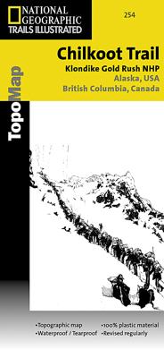
Wandelkaart - Topografische kaart 254 Chilkoot Trail | National Geographic

0
Prachtige geplastificeerde kaart van het nationaal park. Met alle recreatieve voorzieningen als campsites, maar ook met topografische details en wandelroutes ed. Door uitgekiend kleurgebruik zeer prettig in gebruik. Scheur en watervast!   National Geographic's Trails Illustrated map for Chilkoot Trail in Klondike Gold Rush National Historic Park ...

Verkopers met dit product

Verkoper
Bezorging
Prijs
DeZwerver.nl logo
DeZwerver.nl
2,95
16,95

Anderen bekeken ook

Wandelkaart - Topografische kaart 146 Uncompahgre Plateau South | National Geographic
Prachtige geplastificeerde kaart van het bekende nationaal park. Met alle recreatieve voorzieningen als campsites, maar ook met topografische details en wandelroutes ed. Door uitgekiend kleurgebruik zeer prettig in gebruik. Scheur en watervast!   National Geographic's Trails Illustrated map of Uncompahgre Plateau South is a two-sided, waterproof map designed to meet the needs of outdoor enthusiasts with unmatched durability and detail. This map was created in conjunction with local land management agencies and is loaded with valuable recreation information.   The front side of the map details the southeastern portion of the Plateau and Uncompahgre National Forest, as well as Ridgway State Park. On the reverse side of the map, the southwestern portion of Uncompahgre National Forest, including the Naturita Division, is featured as well as the Tabeguache Area, Roubideau Special Management Area, Unaweep/Tabeguache Scenic and Historic Byway, and Dry Creek Basin and Dan Noble State Wildl…
17,95
Wandelkaart - Topografische kaart 261 Grand Canyon | National Geographic
Prachtige geplastificeerde kaart van het bekende nationaal park. Met alle recreatieve voorzieningen als campsites, maar ook met topografische details en wandelroutes ed. Door uitgekiend kleurgebruik zeer prettig in gebruik. Scheur en watervast!   Explore the uniquely inspiring and wondrous landscape of the Grand Canyon with National Geographic's Trails Illustrated map of Grand Canyon National Park, North and South Rims. Expertly researched and created in partnership with local land management agencies, this map is designed to meet the needs of outdoor enthusiasts with unmatched detail of the heart of the park. Key areas of interest featured on this map include Colorado River miles 60-98, North and South Rim visitor centers, Grand Canyon Village, Tusayan, Bright Angel Trail (plus elevation profile), West Rim Trail, Kaibab Trail, Arizona Trail, and more.   With miles of mapped trails in some of the most breathtaking scenery in the entire country, the Grand Canyon North and South Rims ma…
16,95
Wandelkaart - Topografische kaart 147 Uncompahgre Plateau North | National Geographic
Prachtige geplastificeerde kaart van het bekende nationaal park. Met alle recreatieve voorzieningen als campsites, maar ook met topografische details en wandelroutes ed. Door uitgekiend kleurgebruik zeer prettig in gebruik. Scheur en watervast! National Geographic's Trails Illustrated map of Uncompahgre Plateau North is a two-sided, waterproof map designed to meet the needs of outdoor enthusiasts with unmatched durability and detail. This map was created in conjunction with local land management agencies and is loaded with valuable recreation information.   The front side of the map details the northeastern section of Uncompahgre National Forest and the Roubideau Area, the eastern portions of Dominguez Escalante National Conservation Area and Dominguez Canyons Wilderness, and the city of Delta. On the reverse side of the map, the northwestern section of Uncompahgre National Forest is featured as well as the Tabeguache Area, Grand Mesa National Forest, and the western portions of Domin…
17,95
Wandelkaart - Topografische kaart 747 Green Mountain National Forest North - Moosalamoo NRA - Rutland | National Geographic
Prachtige geplastificeerde kaart van het bekende nationaal park. Met alle recreatieve voorzieningen als campsites, maar ook met topografische details en wandelroutes ed. Door uitgekiend kleurgebruik zeer prettig in gebruik. Scheur en watervast! National Geographic's Green Mountain National Forest North Trails Illustrated topographic map is the most comprehensive available for outdoor enthusiasts of all types. Designed to be easy-to-read, yet highly detailed – this map includes a comprehensive road and trail network distinguishing between major, secondary and 4x4 roads, hiking, horse, biking, multi-use and non-motorized winter trails. All forest roads are labeled with their official road number and trails are clearly identified with their given name. Land management boundaries are color-coded showing National Forest, Ranger District, Wilderness Areas, Conservation Areas and more, plus the locations of private land within the Green Mountain National Forest. The renowned Appalachian Trai…
17,95
Wandelkaart - Topografische kaart 746 Adirondack Park - Saranac - Paul Smiths | National Geographic
Prachtige geplastificeerde kaart van het bekende nationaal park. Met alle recreatieve voorzieningen als campsites, maar ook met topografische details en wandelroutes ed. Door uitgekiend kleurgebruik zeer prettig in gebruik. Scheur en watervast!   National Geographic's Trails Illustrated map of Adirondack Park Saranac/Paul Smiths is a two-sided, waterproof, topographic trail map designed to meet the needs of outdoor enthusiasts with unmatched durability and detail. This map was created in cooperation with the Adirondack Mountain Club and is loaded with valuable recreation information, from the marsh to the forest, alongside lakes and through historic neighborhoods. Trails and major roads are clearly distinguished, along with canoe access and ski areas. Campgrounds, lookout towers, rock climbing, and fishing easements are labeled and easy to find and boundaries for park lands, wilderness, primitive, forest, and protected areas are clearly marked. Discover the Adirondack's wild, rugged a…
17,95
Wegenkaart - landkaart 3117 Adventure Map Alaska | National Geographic
Wegenkaart van Alaska met vermelding van veel bezienswaardigheden, nationale parken en attrakties. Watervast en scheurvast. Alaska is a land so vast that is boggles the imagination. It is so large that it could easily contain the next three largest states: Texas, California, and Montana and still have room left over. Despite its large size Alaska has very few inhabitants making it the state with the lowest population density. Alaska is known for its dramatic, diverse terrain of wide-open spaces, mountains and forests, with abundant wildlife and many small towns.   A majority of Alaska, sixty percent, is owned and managed by the Federal Government. These lands are open to the public and offer a wide range of activities from sightseeing in Denali National Park to river-running and fishing on one of many wild rivers. Many vistors to Alaska choose to arrive via cruise ship through the famous Inside Passage. The Alaska Adventure Map shows all of these features and more from the temperate r…
17,50
Wandelkaart - Topografische kaart 226 Joshua Tree National Park | National Geographic
Prachtige geplastificeerde kaart van het bekende nationaal park. Met alle recreatieve voorzieningen als campsites, maar ook met topografische details en wandelroutes ed. Door uitgekiend kleurgebruik zeer prettig in gebruik. Scheur en watervast! This Trails Illustrated topographic map for Joshua Tree National Park and the surrounding area in California is the perfect recreational map for this fascinating land of surreal geologic features shaped by strong winds, unpredictable torrents of rain, and climatic extremes.   The map includes Joshua Tree National Park in its entirety, the Little San Bernardino Mountains, Nexie Mountains, Lost Horse Valley, Quail Springs Historic Trail, Black Rock Canyon, Hidden Valley, Pinto Basin, Chuckwalla Valley, Cottonwood Mountains, Pinto Mountains, Cottonwood Spring Nature Trail, and more. The trails have been enhanced and road and trail mileage have been added for additional accuracy. Includes UTM grids for use with your GPS unit.  
17,95
Wandelkaart - Topografische kaart 803 Lake Tahoe Basin | National Geographic
Prachtige geplastificeerde kaart van het bekende nationaal park. Met alle recreatieve voorzieningen als campsites, maar ook met topografische details en wandelroutes ed. Door uitgekiend kleurgebruik zeer prettig in gebruik. Scheur en watervast! The largest alpine lake in North America, Lake Tahoe straddles the border of California and Nevada. It's unusually clear waters and surrounding Sierra Nevada mountains make it one of the most beautiful lakes in the world. National Geographic's Trails Illustrated map of Lake Tahoe Basin delivers unmatched detail and valuable information to assist you in enjoying the year-round recreational opportunities this region offers. Expertly researched and created in partnership with local land management agencies, this map includes Desolation Wilderness; Prosser Creek Reservoir; Granite Chief and Mount Rose wilderness areas; and El Dorado, Humboldt-Toiyabe and Tahoe National Forests. In addition, the following state parks are included: Donner Memorial, E…
17,95
Wandelkaart - Topografische kaart 220 Dinosaur National Monument | National Geographic
Prachtige geplastificeerde kaart van het bekende nationaal park. Met alle recreatieve voorzieningen als campsites, maar ook met topografische details en wandelroutes ed. Door uitgekiend kleurgebruik zeer prettig in gebruik. Scheur en watervast! This Trails Illustrated topographic map for Dinosaur National Monument, which straddles the state lines of northwest Colorado and northeast Utah, is the perfect recreational map for this stunning monument. Within its craggy hills, you can discover pieces of a long ago world where the largest land creatures of all time once roamed and died.   The map includes the entire national monument area, with detailed trails and topographic information. Included are the Lodore Nature Trail, The Green River, Yampa River, Jenny Lind Rock, Harpers Corner Nature Trail, Rainbow Park, Dinosaur Quarry, the Green Riuver Campground, and much more. The map is full of detailed trail information, park information, history and culture, geology, and natural history.
16,95
Wandelkaart - Topografische kaart 201 Trails Illustrated Yellowstone National Park | National Geographic
Prachtige geplastificeerde kaart van het bekende nationaal park. Met alle recreatieve voorzieningen als campsites, maar ook met topografische details en wandelroutes ed. Door uitgekiend kleurgebruik zeer prettig in gebruik. Scheur en watervast! National Geographic's Trails Illustrated map of Yellowstone National Park is designed to meet the needs of outdoor enthusiasts by combining valuable information with unmatched detail of America's first national park. Expertly researched and created in partnership with local land management agencies, this map features key points of interest including Mammoth Hot Springs, Canyon Village, Yellowstone Lake, Yellowstone Falls, Grant Village, and Old Faithful geyser area.   With over 1,000 miles of mapped trails, the Yellowstone National Park map can guide you off the beaten path and back again. The clearly marked trails include mileages between intersections. Trail summaries provide elevation, duration, and difficulty for a variety of suggested hike…
16,95

Klanten-reviews van Wandelkaart - Topografische kaart 254 Chilkoot Trail | National Geographic

Er zijn nog geen beoordelingen voor dit productBen jij de eerste die een review plaatst?

Meer over Wandelkaart - Topografische kaart 254 Chilkoot Trail | National Geographic

Productomschrijving

Prachtige geplastificeerde kaart van het nationaal park. Met alle recreatieve voorzieningen als campsites, maar ook met topografische details en wandelroutes ed. Door uitgekiend kleurgebruik zeer prettig in gebruik. Scheur en watervast!   National Geographic's Trails Illustrated map for Chilkoot Trail in Klondike Gold Rush National Historic Park in the Alaskan panhandle is perfect for hiking, camping, and wildlife viewing in this scenic, rugged frontier. Created in partnership with local land management agencies, this expertly researched map features key areas of interest including Chilkoot Trail National Historic Site; portions of the Klondike Highway; Happy Camp; Taiya Inlet; the town of Skagway; Klondike Gold Rush National Historical Park; Skagway River; Dyea; and Deep, Bennett, Crater, Long, and Lindeman lakes.   The print map includes insets of historic routes to the Klondike gold fields, Historic Dyea, and Skagway Historic District with some of the prominent gold rush-era buildings noted. There is a great deal of helpful material about traveling in the area, customs, permits and fees, safety tips, agency contact information, a suggested equipment list, and more. A trail profile of Chilkoot Trail is included as well. A table of featured hiking trails showing distance, approximate hiking time, elevation gain, difficulty, and features will help you choose a path that's right for you. The map base includes contour lines, shaded relief, and elevations for summits, passes and many lakes. Recreation features are clearly marked, including campgrounds, public use cabins, cross country ski and snowshoeing areas, interpretive areas, and scenic viewpoints.   Every Trails Illustrated map is printed on "Backcountry Tough" waterproof, tear-resistant paper. A full UTM grid is printed on the map to aid with GPS navigation.   Other features found on this map include: Klondike Gold Rush National Historical Park, Mount Foster, Tongass National Forest.


Productinformatie

    Verken gerelateerde categorieën

    Webshop.nl maakt gebruik van cookies. Ga je verder op onze website, ga dan akkoord met het plaatsen van cookies en de verwerking van deze data door ons en vermelde partners.