webshop.nl
Categorieën
  Sluiten

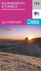
Wandelkaart - Topografische kaart 195 Landranger Bournemouth & Purbeck | Ordnance Survey

Take a walk on the sunny side of life in beautiful south Dorset. Relax on Bournemouth’s sandy beaches or explore the Jurassic Coast peninsula of the Isle of Purbeck, home to the world-famous beaches of Swanage and Lulworth Cove.   Visit the charming riverside town of Wimborne Minster set amidst the Cranborne Chase Area of Outstanding Natural Bea...
19,50

Webshops met dit product

Webshop
Bezorging
Prijs

Anderen bekeken ook

Wandelkaart - Topografische kaart OL15 OS Explorer Map Purbeck and South Dorset | Ordnance Survey
Gaze back through 185 million years of history as you explore the Jurassic Coast or go wildlife spotting in the South Dorset countryside. Sweeping golden beaches and spectacular cliff scenery await you on the Purbeck Peninsula as the South West Coast Path takes you from Chesil Beach to Europe’s largest natural bay at Poole.   - Hunt for fossils and dinosaur tracks on the unique Jurassic Coast beaches of Kimmeridge Bay, Lulworth Cove and the iconic sweeping shingle ridge of Chesil Beach - Discover the world-famous Sandbanks Beach in Poole, climb Europe’s largest Iron Age hillfort at Maiden Castle and relax in sunny Weymouth, home of the sailing at London 2012 - Explore the Purbeck Peninsula with its chalk cliffs, the magnificent ruin of Corfe Castle, Victorian pier at Swanage and Brownsea Island Een van de beste detailkaarten die er op de wereld gemaakt worden: zeer gedetailleerd, prachtig helder kleurgebruik, veel topografische aspecten en - zeer belangrijk - allerlei toeristische e…
19,50
Wandelkaart - Topografische kaart 361 OS Explorer Map Isle of Arran | Ordnance Survey
Met zijn 4cm voor 1 km (2 ½ cm voor 1 mijl) schaal, is de OS Explorer kaartenserie de ideale en meest gedetailleerde kaartenreeks voor mensen die graag outdoor-activiteiten zoals fietsen, wandelen, paardrijden, klimmen en watersporten. Deze kaart is nog gedetailleerder dan de 'gewone' Landranger maps. Voor- en achterzijde bedrukt! Zeker op de moors en andere natuurgebieden van onschatbare waarden met echt alle aspecten van het landschap op de kaart ingetekend. Zeer goede detailkaart met topografische ondergrond. Hierop zijn toeristische symbolen van bezienswaardigheden ingetekend, daarnaast staan bijvoorbeeld campings en jeugdherbergen vermeld en - voor wandelaars het belangrijkst - alle right of way paden en Lange afstands Wandelpaden zijn er op te vinden. De ideale kaart voor het wandelen in Engeland, Wales of Schotland.   Experience ‘Scotland in miniature’ on the Isle of Arran, with its rocky, wild highlands in the north and lush lowlands in the south. Climb Goat Fell, the highest …
27,50
Wandelkaart - Topografische kaart OL08 OS Explorer Map Chichester, South Harting & Selsey | Ordnance Survey
Explore the South Downs National Park, follow the South Downs Way up to the picturesque village of South Harting sheltered beneath Harting Down. Discover Chichester Harbour with its delightful fishing villages or range further afield to Selsey at the tip of the Manhood Peninsula.    Seek unspoiled coastlines and countryside on Hayling Island, where windsurfing was invented  Marvel at Chichester’s intact Roman walls and cathedral tower now home to a family of peregrine falcons  Walk or cycle the South Downs Way through gorgeous countryside past South Harting, or explore Chichester Harbour on the Sussex Border Path and Shipwrights Way    Met zijn 4cm voor 1 km (2 ½ cm voor 1 mijl) schaal, is de OS Explorer kaartenserie de ideale en meest gedetailleerde kaartenreeks voor mensen die graag outdoor-activiteiten zoals fietsen, wandelen, paardrijden, klimmen en watersporten. Deze kaart is nog gedetailleerder dan de 'gewone' Landranger maps. Voor- en achterzijde bedrukt! Zeker op de moors en…
19,50
Wandelatlas 3 Adventure Atlas South West Coast Path South Cornwall | A-Z Map Company
AZ heeft de meest gedetailleerde wandelkaarten van delen van het South West Coast Path  gebundeld in een atlasje. Daardoor is het heel handig qua formaat. De kaarten zelf zijn perfect voor het wandelen. Schaal 1:25.000 The perfect companion for those who love the great outdoors, the A-Z Adventure Series features OS 1:25000 mapping in a convenient book, complete with index.   The South West Coast Path is a National Trail along the Somerset, Devon, Cornwall and Dorset coasts. This stunning walk from Minehead, Somerset covers 630 miles to South Haven Point in Poole Harbour, passing through two World Heritage Sites (the Jurassic Coast and the Cornwall and West Devon Mining Landscape), Exmoor National Park, Land's End and many areas of outstanding natural beauty.   A series of five A-Z Adventure Atlases together cover the South West Coast Path:   SW Coast Path North Devon and Somerset SW Coast Path North Cornwall SW Coast Path South Cornwall SW Coast Path South Devon SW Coast Path Dorset Th…
12,95
Wandelatlas 1 Adventure Atlas South West Coast Path North Devon & Somerset | A-Z Map Company
AZ heeft de meest gedetailleerde wandelkaarten van delen van het South West Coast Path  gebundeld in een atlasje. Daardoor is het heel handig qua formaat. De kaarten zelf zijn perfect voor het wandelen. Schaal 1:25.000 The perfect companion for those who love the great outdoors, the A-Z Adventure Series features OS 1:25000 mapping in a convenient book, complete with index.   The South West Coast Path is a National Trail along the Somerset, Devon, Cornwall and Dorset coasts. This stunning walk from Minehead, Somerset covers 630 miles to South Haven Point in Poole Harbour, passing through two World Heritage Sites (the Jurassic Coast and the Cornwall and West Devon Mining Landscape), Exmoor National Park, Land's End and many areas of outstanding natural beauty.   A series of five A-Z Adventure Atlases together cover the South West Coast Path: SW Coast Path North Devon and Somerset SW Coast Path North Cornwall SW Coast Path South Cornwall SW Coast Path South Devon SW Coast Path Dorset…
12,95
Wandelatlas 2 Adventure Atlas South West Coast Path North Cornwall | A-Z Map Company
AZ heeft de meest gedetailleerde wandelkaarten van delen van het South West Coast Path  gebundeld in een atlasje. Daardoor is het heel handig qua formaat. De kaarten zelf zijn perfect voor het wandelen. Schaal 1:25.000 The perfect companion for those who love the great outdoors, the A-Z Adventure Series features OS 1:25000 scale mapping in a convenient book, complete with index.   The South West Coast Path is a National Trail along the Somerset, Devon, Cornwall and Dorset coasts. This stunning walk from Minehead, Somerset covers 630 miles to South Haven Point in Poole Harbour, passing through two World Heritage Sites (the Jurassic Coast and the Cornwall and West Devon Mining Landscape), Exmoor National Park, Land's End and many areas of outstanding natural beauty.   A series of five A-Z Adventure Atlases together cover the South West Coast Path:   SW Coast Path North Devon and Somerset SW Coast Path North Cornwall SW Coast Path South Cornwall SW Coast Path South Devon SW Coast Path Dor…
12,95
Wandelkaart - Topografische kaart 150 OS Explorer Map Canterbury, Isle of Thanet | Ordnance Survey
Discover Canterbury, city of saints and kings, ancient heartland of England at the foot of the Kent Downs and the head of the River Stour Valley with its vineyards. Follow the river to the coast to discover unspoiled Deal, artistic Margate and picturesque Whitstable.  Starting in Canterbury, take the Stour Valley Walk to Sandwich and the long sweeping sand and shingle beach of Sandwich Bay  Walk the Long Rock from Whitstable to Herne Bay before taking the Thanet Coastal Path around the Isle of Thanet and its three famous Georgian and Victorian resorts of Margate, Ramsgate and Broadstairs   Take the National Trails of the England Coast Path and North Downs Way or choose from a lattice of other popular recreational paths  Met zijn 4cm voor 1 km (2 ½ cm voor 1 mijl) schaal, is de OS Explorer kaartenserie de ideale en meest gedetailleerde kaartenreeks voor mensen die graag outdoor-activiteiten zoals fietsen, wandelen, paardrijden, klimmen en watersporten. Deze kaart is nog gedetailleerd…
19,50
Wandelgids Wales Coast Path: Snowdonia and Ceredigion | Northern Eye Books
Official Guide: Wales Coast Path: Snowdonia & Ceredigion Coast One of seven Official Guides to the Wales Coast Path This Official Guide to the Snowdonia & Ceredigion Coast section of the Wales Coast Path contains everything local and long-distance walkers need to enjoy the path.   Cardigan Bay probably offers a more diverse walking experience than any other section of the Wales Coast Path. The stretch covered in this book – from Porthmadog in the north to Cardigan in the south – largely covers two contrasting Welsh counties.   The first 97 kilometres pass through Gwynedd, along the western edge of the Snowdonia National Park. Here, just before the rivers that rise in the highest of the Welsh mountains reach the sea, they fan out to form broad estuaries that provide rich pickings for waders and other birdlife. The estuaries of the Dwyryd, the Mawddach and the Dyfi are the largest of these. Between them are some very large dune systems, including Morfa Harlech and Morfa Dyffryn – home to…
23,95
Fietskaart Cycling guides Dartmoor - South Devon | Goldeneye
Dartmoor. One of England’s greater National Parks; the Forest of Dartmoor covers 365 square miles and contains the highest ground in England south of the Peak District. On its desolate moorland tracks the wanderer can believe they are further from a public road than anywhere in the country, but on the fringes lush valleys lead down on every side to thick woodland, green vegetation and picturesque villages. Dartmoor is well known for its wildlife - attractive herds of ponies, seemingly wild but in fact individually owned, foxes, badgers and otters - also the occasional adder. Fallow, roe and Sitka deer can often be seen, but the red deer of Exmoor have never penetrated the area. Buzzards, kestrels and various Birds of Prey are frequently seen, as well as the wheatear, while crows, ravens and the skylark are fairly commonplace. The Moor abounds in prehistoric remains. There are also many deserted medieval villages with remains of the traditional ‘longhouse’ buildings. For centuries tin m…
12,95
Wandelkaart 3 South West Coast Path 3 | Harvey Maps
Een bijzonder handige kaart voor een deel van dit lange-afstands-wandelpad (Minehead tot St Ives) van het in totaal maar liefst 1014 km lange South West Coast Path. Op waterafstotend papier met veel details, uitstekend en voldoende voor dit deel van de route. De totale route bestaat uit 3 kaarten.    The South West Coast path is a 1014km (630mile) long distance path and the longest National Trail in England. The path stretches from Minehead in Somerset to Poole in Dorset. - This updated Trail Map covers the third and final section of the South West Coast Path from Plymouth to Poole Harbour which is 339km (211 miles).   - Includes the Jurassic Coast World Heritage Site and Durdle Door, the famous sea arch in Dorset. - The entire route on 3 sheets. This is map 3 of 3, a good two weeks? walking on one map.   - The XT40 is based on original HARVEY mapping with all the detail a walker would expect on a map at 1:40,000 scale. - Clear and easy to read mapping which is uncluttered by info…
25,95

Klanten-reviews van Wandelkaart - Topografische kaart 195 Landranger Bournemouth & Purbeck | Ordnance Survey

Er zijn nog geen beoordelingen voor dit productBen jij de eerste die een review plaatst?

Meer over Wandelkaart - Topografische kaart 195 Landranger Bournemouth & Purbeck | Ordnance Survey

Productomschrijving

Take a walk on the sunny side of life in beautiful south Dorset. Relax on Bournemouth’s sandy beaches or explore the Jurassic Coast peninsula of the Isle of Purbeck, home to the world-famous beaches of Swanage and Lulworth Cove.   Visit the charming riverside town of Wimborne Minster set amidst the Cranborne Chase Area of Outstanding Natural Beauty From the market town of Ringwood, explore the New Forest National Park  Walk, hike and cycle along the South West Coast Path through the Dorset and East Devon Coast World Heritage Site    Zeer goede detailkaart met topografische ondergrond. Kleurgebruik is goed over nagedacht: bijzonder goed leesbaar en helder kaartbeeld. Hierop zijn toeristische symbolen van bezienswaardigheden ingetekend, daarnaast staan bijvoorbeeld campings en jeugdherbergen vermeld en - voor wandelaars het belangrijkst - alle right of way paden en Lange afstands Wandelpaden zijn er op te vinden. De ideale kaart voor het wandelen in Engeland, Wales of Schotland. De kaarten zijn te gebruiken met GPS (UTM OSGB36), de legenda is in het Engels, Frans en Duits.    Plaatsen op deze kaart: Bournemouth, Purbeck, Wimborne Minster, Poole, Christchurch, Ringwood, Fordingbridge, Wareham, Swanage, Corfe Castle, Upton, Corfe Mullen, Lytchett, Spetisbury, Witchhampton, Tarrant Hilton, Gussage All Saints, Three Legged Cross, Longham, Hurn, Bransgore, Ferndown, Cranborne, Alderholt, Verwood, North Gorley, Burley, Sway, New Milton, and Milford on Sea   Ingetekende Langeafstandswandelroute South west coast Path  
Webshop.nl maakt gebruik van cookies. Ga je verder op onze website, ga dan akkoord met het plaatsen van cookies en de verwerking van deze data door ons en vermelde partners.